4-Day Rwenzori Trek to Mutinda Lookout via Kilembe Trail
The 4-Day Rwenzori trek to Mutinda Lookout (3,975m) via the Kilembe Trail is an immersive, fully guided Ugandan expedition that uses the “climb high, sleep low” method. It traverses Afro-montane forests and the Nyamwamba Valley, offering panoramic views of Mount Stanley and Mount Baker.
While the third day’s descent through the bamboo zone is much easier than the climb, you’ll still need to be careful on the muddy, root-infested parts of the track. This is the kind of place where trekking poles and a leisurely pace really shine. The transitional zone is where the morning feeding activity peaks, so the bamboo corridor on the way down is usually busier with birds than it is on the way up.
When you step back into the Afro-Montane forest that lies beneath the bamboo zone, you’ll feel the warmth and hear the birdsong that was missing before. Two possible paths may be presented by your guide near the Omusita Rest Area: one descends directly to the ranger post, while the other takes a picturesque diversion along the Nyamwamba River, passing through an especially evocative stretch of old-growth forest that seems ancient, thick, and primordial. If you have the time and the weather permits, you should definitely follow the river route; it is among the most picturesque parts of the lower Kilembe Trail.
At the end of the day, the hike usually reaches the Kyanjuki base camp after passing the UWA ranger station. At the trailhead, we say goodbye to our guides, swap completion certificates, and divide up any tips. It is possible to organise transportation from Kyanjuki to either Kasese or Fort Portal. Before continuing on their journey, many hikers opt to spend the night in Kasese.
This hike is great for anyone who wants to train at high elevations, see gorgeous scenery, and have a real wilderness experience but doesn’t have a lot of time. For those who are new to hiking or who want to get a taste of longer peak treks like Margherita Peak, the 4-Day Rwenzori Trek to Mutinda Lookout via Kilembe Trail is a great option. By allowing you to “climb high, sleep low,” it also aids in acclimatisation to the altitude.
Why the 4-Day Rwenzori Trek to Mutinda Lookout?
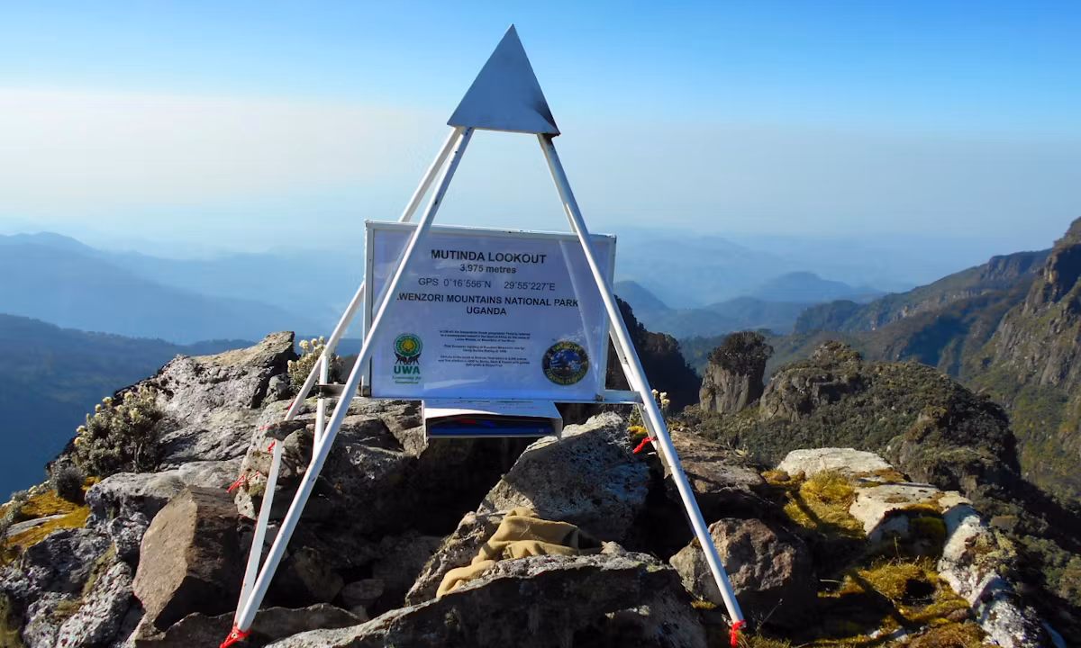
The highest point that can be reached on a non-summit Rwenzori trek is Mutinda Lookout, which stands at 3,975 meters. High above the bamboo and Afro-montane forest belt in the Kilembe Trail’s upper moorland zone, you’ll find spectacular high-altitude bogs, two-meter-tall tree heathers, and gigantic lobelias. The glaciated peaks of Mount Stanley and Mount Baker, which summit-bound trekkers spend seven or eight days ascending, can be seen above the cloud line on a clear morning from the Mutinda ridge. After four, this is what you get. Without the tricky glacier portions, the altitude above 4,500 meters, or the 7 to 8 day commitment needed for a summit expedition, this journey provides a unique proposition: maximum altitude, maximum scenery, and maximum absorption in the fabled environment of the Rwenzori Mountains.
Starting from the historic copper mining town of Kilembe instead of the north side at Nyakalengija, the Kilembe Trail is the Rwenzori’s southern path. Because of this, it differs greatly in personality from the Central Circuit Trail. Beginning in a thick bamboo and montane forest, the Kilembe approach winds its way up via a succession of waterfalls and high river gorges until emerging onto open moorland at an elevation of 3,500 meters. Many seasoned hikers prefer this route since it is less used than the Central Circuit and offers a sense of adventure and discovery that the Central Circuit lacks. After completing the Central Circuit, the 4-day Mutinda trek via Kilembe is a great next step for anyone looking to see the Rwenzori from a fresh perspective.
Kilembe base, Sine Camp (2,571 m), Samalira Camp (2,860 m), and Mutinda Camp (3,668 m) are the four camps that make up this route. They all stand for different biological stages that the mountain has gone through. After three days of hiking, you will have slept on the upper heather moorland and climbed 3,975 meters to a sight that most tourists to Rwenzori never get to see. What sets serious Rwenzori trekking apart is the gigantic lobelia colonies above Samalira, the hypericum moorland that stretches toward the ridge, and the utter solitude of the top mountain at this elevation. To help hikers choose the best path for their needs, we’ve compared the Central Circuit and the Kilembe Trail in detail.
If you are asking if this 4-day walk may be used as a springboard to a full summit ascent, the answer is always yes. An excellent acclimatisation and fitness test is Mutinda Lookout, which stands at 3,975 meters. Those that make it there in good health will be in a good position to do the 8-day Kilembe Trail or 7-day Central Circuit climbs of Margherita Peak. The most direct and comprehensive approach to determining if the summit is right for you is to spend four days at Mutinda.
A Detailed 4-Day Rwenzori Trek to Mutinda Lookout Itinerary
Day 1: Kilembe Trailhead to Sine Camp | 1,500 m to 2,571 m | ~9 km | 4 to 5 hours
Kilembe, a village at the base of the southern slopes of the Rwenzori Mountains, is the starting point of the 4-day Rwenzori journey to Mutinda Lookout. The town is known for its copper mining history. Compared to the Central Circuit’s Nyakalengija entrance point, the trailhead is situated somewhat lower at around 1,500 meters. The track heads north into the lower montane forest after registering and checking equipment at the Uganda Wildlife Authority ranger post.
In the first day’s 9 kilometres, you’ll ascend 1,071 meters, setting the tone for the whole trek: steady ascent through ever-more-dense and stunning flora. Starting from Kilembe, the trail ascends through agricultural areas and banana plantations before eventually reaching the lower forest boundary of Rwenzori Mountains National Park. The change from farmed land to protected forest is sudden and obvious in the humidity, temperature, and bird song density.
The lower montane zone becomes noticeable within the first hour of reaching the forest. A 20-meter-tall canopy covered in moss is formed by Podocarpus trees and towering tree ferns. The path winds its way uphill over forested and steep terrain as it follows the left bank of a river tributary, fording small streams along the way. It’s not uncommon to find three-horned chameleons on the trail. Throughout this part, you can hear black-and-white colobus monkeys smashing through the trees above. They live in the high canopy. Deep in the heart of the forest, you can hear the Rwenzori turaco calling.
By early afternoon, they have climbed 2,571 meters to Sine Camp. Camp is located in a clearing in the forest, next to a river, and offers views up the valley towards the higher ridgelines. Sleeping quarters are available in wooden huts overseen by the Uganda Wildlife Authority. Upon arrival, your camp cook will begin preparing dinner. Sine Camp is a place of frigid stillness in the evenings. After dark, the temperature lowers to 12 to 15 degrees Celsius as the forest encircles the clearing.
Day 2: Sine Camp to Samalira Camp | 2,571 m to 2,860 m | ~8 km | 4 to 5 hours
Although there is less elevation gain on Day 2 of the 4-Day Rwenzori Trek to Mutinda Lookout, it is one of the best days to observe wildlife and flowers. Ascending steadily to Samalira Camp at 2,860 metres, the trail continues northward from Sine Camp through the mid-altitude forest, passing through the bamboo zone. Day 2’s milder 289-meter ascent over 8 kilometres allows you more time to relish in the ever-changing flora and fauna as you go.
This stretch of the Kilembe Trail boasts one of the best bamboo forest sections in the whole Rwenzori range. Along the walk, you’ll find stands of giant bamboo (Arundinaria alpina), which can reach a height of 15 meters and provide a breathtaking sense of seclusion. Here you can find the Rwenzori double-collared sunbird, mountain illadopsis, and African emerald cuckoo, three of the bamboo-specialist birds found on the Kilembe side of the mountain. With our Rwenzori wildlife guide, you’ll get access to a comprehensive species catalogue complete with identification notes.
The trail enters upper Afro-montane woodland, where Hypericum and Hagenia abyssinica are the dominant trees, after passing the bamboo zone. You can tell you’re getting close to the boundary between forest and moorland since these are the first high-altitude tree species in the Rwenzori. Above 2,700 meters, you’ll start to see the first big lobelias. These bizarre-looking rosette plants can reach a height of 4 meters, and they have enormous waxy leaves at the base of their flower spikes. Any Kilembe Trail hiker will remember the first time they saw one of these unique Rwenzori plant species.
Located at an elevation of 2,860 meters, Samalira Camp marks the beginning of the open heather moorland and a transition zone between the higher forest and the surrounding wilderness. Aside from a stream, the camp features pit latrines, wooden houses, and water. From the camp clearing, one can see all the way to Kilembe across the valley and out to the ridgelines of the drainage’s western side. The sky is very breathtaking from this vantage point on clear evenings.
Day 3: Samalira Camp to Mutinda Lookout & Return to Mutinda Camp | 2,860 m to 3,975 m | ~14 km | 6 to 8 hours
The 4-Day Rwenzori Trek to Mutinda Lookout. The trail leaves Samalira Camp and heads north, climbing through the upper woodland and into the open moorland. It reaches Mutinda Camp at 3,668 meters, and then there’s one last push to the Mutinda Lookout peak at 3,975 meters. With an impressive elevation increase of 1,115 meters and the start of altitude effects above 3,500 meters, this is the longest and most difficult day of the four.
If you want to maximise your chances of seeing clear skies at Mutinda Lookout before the clouds roll in for the afternoon, it’s better to leave Samalira Camp before sunrise (06:30). After 30 minutes of hiking out of camp, the trail above Samalira reaches the complete moorland zone. The terrain opens up considerably as the tree cover breaks. Both sides of the trail are lined with densely spaced giant lobelias. At an altitude of around 3,200 meters, you can start to see giant groundsels (Dendrosenecio adnivalis), which are similar to garden groundsels but larger, with their sturdy trunks crowned with rosettes of silver-green leaves. Almost every shot of the Rwenzori range features this spot, which is the famous enormous plant scene.
There is a 3,000 to 3,500 metre ascent along the trail over high-altitude muck and moorland. The traditional Rwenzori landscape is characterised by its soft, uneven surface made of sphagnum moss, tussock grasses, and wet peat. One must be cautious when placing their feet on this terrain. Regardless of the season, rubber boots are a must-have here. For those seeking an explanation as to why rubber boots are an absolute must in the higher mountain zones, the Rwenzori boot and footwear guide provides just that.
At an elevation of 3,668 meters, Mutinda Camp is reached after around four hours of hiking from Samalira. With far lower temperatures than the lower camps, this high, exposed site in the open moorland offers panoramic vistas. Leaving Mutinda Camp after a brief lunch break and relaxation, the trail ascends 307 meters to reach the 3,975-meter Mutinda Lookout crest. The last stretch is a difficult ascent across heather moorland and exposed rocky landscape; from the peak, you may enjoy one of the best views on the Rwenzori without having to cross any glaciers.
At an elevation of 3,975 meters, Mutinda Lookout offers a panoramic view of the upper Rwenzori. With a clear sky, which is typical from December to February and June to August, you can make out the glaciered peaks of Mount Stanley (5,109 m), which includes Margherita Peak, and Mount Baker (4,843 m) above the cloud cover. From here, one can see the whole upper Bujuku Valley as well as the ridge systems that make up the Central Circuit. At lower elevations, this is the best observation point on the mountain for hikers to get a feel for the landscape before committing to a summit ascent.
Returning to Mutinda Camp for the third night, after spending some time at the lookout. At 3,668 meters, the camp is the highest place on this route where you can sleep. After sunset, temperatures plummet to 2–5 degrees Celsius. A down sleeping bag with a temperature rating of at least -5 degrees Celsius is a need. The camp cook makes the supper. If the weather is right, the night sky at Mutinda Camp is very breathtaking, considering the altitude and latitude.
Day 4: Mutinda Camp to Kilembe Trailhead | 3,668 m to 1,500 m | ~13 km | 5 to 6 hours
On the last day of the four-day Rwenzori trek to Mutinda Lookout, you’ll descend 2,168 meters over around thirteen kilometres, a lengthy and steady drop. After breakfast, you’ll depart from Mutinda Camp and return to the Kilembe trailhead across the moorland, past Samalira Camp, the bamboo forest, and the lower montane zones. Climbing up can take anything from five to six hours at a leisurely pace.
The descent, after three days of ascending, shows the mountain from different viewpoints and in reverse. When you’re not rushing to get to the top of the hill, the gigantic lobelias and groundsels above Samalira take on a new appearance, while the bamboo forest below Samalira reveals more of its intricate details. For many hikers, the descent is the most peaceful portion of the trail, especially on the lower slopes through the forest, where they can listen to the rivers below as they make their way back to the valley.
Returning to the world below is signified by the last segment, which begins at the park boundary and continues through the Kilembe farms. Usually, you’ll get to the Kilembe trailhead somewhere between noon and three in the afternoon. You will have the remainder of the day and evening to relax, recuperate, and contemplate after your transfer back to your lodging in Kasese. Here is a great opportunity for hikers thinking about what to do next: talk to your guide about the Rwenzori Waterfalls Hike, a 4-day side trip on the Kilembe side or the 8-day Kilembe Trail summit expedition.
End of the 4-Day Rwenzori Trek to Mutinda Lookout via Kilembe Trail