7-Day Mount Gessi Trek | Guide to Hiking Bottego Peak
A 7-Day Mount Gessi Trek | Guide to Hiking Bottego Peak. Conquering the remote Mount Gessi (4,715m) in the Rwenzori Mountains is a demanding, highly rewarding expedition. This 7-Day Mount Gessi Trek via the Rwenzori Central Circuit via the Mugusu Valley and Roccato Pass. Because it requires scaling steep mossy slabs and navigating challenging terrain, it is best suited for experienced and physically fit hikers.
Hike the Rwenzori Mountains in Uganda for seven days to reach the peak of Mount Gessi. Hike to the top of the rocky 4,798 m peak via verdant bamboo woods, verdant rainforests and alpine zones. Indulge in an East African trip that is sure to wow serious trekkers.
The Rwenzori is well-known to most hikers as the site of Margherita Peak and the Central Circuit, the routes described and illustrated in every East African travel guide. Meanwhile, there’s the Rwenzori that hardly anyone is familiar with: the secluded western ranges, the untamed cloud camps, and the peaks that have witnessed less human activity in the past ten years than Kilimanjaro does first thing in the morning. Rwenzori Mountain is home to Mount Gessi. At 4,715 meters above sea level, Bottego Peak is the fifth-highest peak in the range and one of the least-visited 4,000-meter peaks in all of Africa.
An all-inclusive expedition, the 7-Day Mount Gessi Trek takes you through each of the five main vegetation zones in the Rwenzori Mountains. Along the way, you’ll spend two nights camping in the wild at Skull Cave and visit the remarkable Lac de Luna, an alpine lake at around 4,200 meters, whose Swahili name means “Lake of the Moon.” Bottego Peak’s summit approach is the epitome of high-altitude mountaineering, what with its fixed ropes, steep rocky terrain, and extreme exposure. From here, you can see all the way into the Democratic Republic of the Congo to the west. You won’t find anything like it anywhere else in Africa.
Why the 7-Day Mount Gessi Trek?
The Mount Gessi trek truly lives up to the marketing term “off the beaten track” in a world where it is frequently used. One of the best hiking routes in Africa, the Central circle Trail passes via Nyabitaba and John Matte. However, after John Matte, where the Gessi path goes west into the park’s interior, you’ll be entering terrain that sees a fraction of the tourists that walk the conventional circle. Short wait times at the cabin. At this camp, there are no other trekking groups. There is nothing but your guiding group, the mountain, and an uncharted environment.
Another distinguishing feature is the element of wild camping. While Skull Cave and Lac de Luna do not constitute huts, they are rather intrinsic mountain features that your guiding team converts into a fully operational camp every night by bringing tents and equipment from lower elevations. An unforgettable travel memory is enjoying a hot supper prepared by your porter team while sitting near a glacially formed lake at 4,200 m, with the silhouette of the DRC border mountains on the western horizon. Less physical comfort, colder evenings, and the indispensability of a -5°C sleeping bag and appropriate cold-weather gear are all demands it places on you.
Among the Rwenzori peaks, the view from the top of Bottego Peak (4,715 m) is unparalleled. Bottego Peak in Gessi views west into the Congolese settlements visible in the foothills on clear days, with the mountains and woods of the DRC stretching to the horizon. Margherita Peak looks down on its own glacier and across to Mount Speke. From this vantage point, you can’t help but feel grounded in your location: atop central Africa, on the edge of a boundary that divides a global hotspot for biodiversity.
After completing the 7-Day Margherita Peak climb or the 5-Day Mount Speke adventure, the next logical goal is the Mount Gessi trek. It’s a totally different experience on the same mountain range, but it aims to reach a summit that relatively few people ever get to. The daring 13-day 6-Peaks Grand Expedition, which ascends all of the main Rwenzori peaks in a continuous traverse, relies on it as well.
A Detailed 7-Day Mount Gessi Trek Itinerary
Day 1: Nyakalengija Trailhead (1,650 m) to Nyabitaba Camp (2,650 m)
Distance: ~10 km | Elevation Gain: ~1,000 m | Hiking Time: 5–6 hours | Terrain: Afro-Montane forest, Mubuku River valley, steep ridge
Starting at 22 km from Kasese, at the Uganda Wildlife Authority ranger station in Nyakalengija, your 7-day Mount Gessi excursion will get underway. Bring your passport and confirmation of reservation with you as this is where park entrance is handled. At the latest by 9:00 AM, the crew will have received a comprehensive briefing from the guides on the week’s route, camp logistics, wild camping protocol, and safety measures.
As you go through the Afro-Montane forest, the initial part of the trail follows the valley of the Mubuku River. Several steep areas can be ascended with the help of ladders, and a succession of wooden bridges span tributary streams. Almost instantly, the forest canopy closes in above, and you instantly and completely feel like you’ve left the lowlands behind. You can hear the rest of the forest preparing for your arrival thanks to the deafening alarm sounds made by black-and-white colobus monkeys, which you may hear frequently in this section’s top canopy.
As the trail ascends towards the Nyabitaba ridge, you’ll see the endemic three-horned Rwenzori chameleon (Trioceros johnstoni) perched on low foliage. The forest will get thicker and more covered in moss as you continue on your walk. In the middle of the canopy, you can always hear the characteristic call of the Rwenzori turaco and see its brilliant red flight feathers. As one climbs higher on sunny days, one may make out the distant contour of Mount Stanley emerging from open ridge parts.
Perched on a hilltop in the woods above the Mubuku Valley, Nyabitaba Camp (2,650 m) is a rustic mountain lodge. Just a short stroll downhill from camp is the Porter’s Rest Bridge, a great place to take pictures because of the panoramic view of the valley it provides. Following supper, your guide will go over the details of crossing the Kurt Shaffer Bridge the next morning and give you the Day 2 briefing.
Day 2: Nyabitaba Camp (2,650 m) to John Matte Camp (3,505 m)
Distance: ~7.5 km | Elevation Gain: ~855 m | Hiking Time: 6–7 hours | Terrain: Bamboo zone, heather zone, Kurt Shaffer Bridge, River Bujuku
As a first stop on Day 2, riders will descend to the Kurt Shaffer Bridge, a Central Circuit symbol that spans the confluence of the Mubuku and Bujuku rivers, where the dark waters crash against the black volcanic rock. The two rivers meet in a tight, dramatic gorge beneath a canopy of overhanging forest, making it one of the top photography places on the lower circuit. Get over the bridge and start climbing up to John Matté.
At about 2,700 meters, you’ll enter the bamboo zone, where towering mountain bamboo (Arundinaria alpina) rises 10 to 12 meters in small lanes that give the path its peculiar muted, greenish glow. Proceed with caution since the path is muddy and the roots of bamboo pose a stumbling hazard to your ankles. In the bamboo transition zone, Rwenzori turacos are incredibly noisy, and their calls reverberate remarkably far through the thick stems.
From this point onwards until the peak, the trek will be defined by the heather zone, which begins when the bamboo fades and is dominated by huge tree heather (Erica arborea and Erica trimera). One of the peaceful delights of the Central Circuit is strolling along the banks of the River Bujuku in the upper heather zone. The river rushes swiftly over mossy boulders and passes by a woodland that is buried in moss. Water is a common occurrence on this path; gaiters or rubber galoshes are quite beneficial.
Perched on a wide heather plateau, John Matte Camp (3,505 m) offers breathtaking views of Mount Stanley and the Margherita face to the north. Because of the significant altitude (around 3,505 m), several hikers report moderate headaches or loss of appetite on the first night. Make sure to stay hydrated, have a hearty dinner, and get a good night’s sleep. On Day 3, this walk departs from the usual path, and tomorrow you’ll start your journey into the wild camp zone.
Day 3: John Matte Camp (3,505 m) to Skull Cave (Wild Camp, ~3,900 m)
Distance: ~6 km | Elevation Gain: ~395 m | Hiking Time: 6–7 hours | Terrain: Boggy heather zone, rocky ridges, remote upper valley
The real nature of the Mount Gessi hike becomes apparent on Day 3. As soon as the track becomes less defined, the environment gets more distant, and the vegetation becomes more challenging, the route departs from the conventional Central Circuit and heads westward from John Matte. Now you’re in an area that only gets a small percentage of the tourists that the major circuit does. Stay on pace and follow your guide closely as they lead the route.
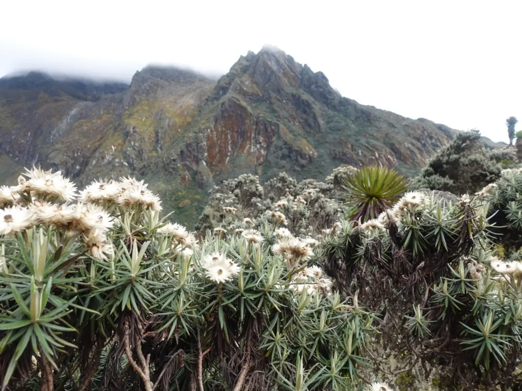
The path passes through a marshy heather zone, which can be rather difficult due to the knee-to ankle-deep muck, standing water, and tussock grass that hides the uneven ground beneath your feet. This area strictly enforces the use of rubber gumboots or neoprene gaiters. Trust the footstep choices of your porters when the path is uncertain; they handle this terrain with trained efficiency. As the bog becomes denser, giant lobelias (Lobelia wollastonii) begin to proliferate, their spike-like inflorescences reaching a height of two to three meters above the valley floor.
As the path ascends from the swamp to the ridges above, the landscape gets steeper and more rugged. As one ascends, one is treated to breathtaking panoramas, with the valley below fading and the main Rwenzori massif stretching out to the east. On the western horizon, one can make out the first hints of the border region with the DRC. At this height, the Afro-alpine plant communities—lobelias, groundsels, and heather—become increasingly prominent, and as you go more into the park’s western interior, their size and density grow even more.
As a reference point for the third day’s camp, Skull Cave (~3,900 m) is a natural rock formation that can be described as a cave or deep overhang in the higher heather and rock zone. Upon your arrival, your porter team will have already prepared meals, set up the camp kitchen, and pitched tents on the covered ground near the cave. Here you are on your first night of wild camping: the most distant, quiet, and frigid place you’ve ever been. Starting tonight, you will be sleeping in a -5°C sleeping bag. When the clouds part, the night sky is just breathtaking.
Day 4: Skull Cave (~3,900 m) to Lac de Luna Camp (~4,200 m)
Distance: ~5 km | Elevation Gain: ~300 m | Hiking Time: 7–8 hours | Terrain: Steep rocky ascent, upper alpine zone, DRC border views
Before reaching the peak, Day 4 is the most physically demanding day. Even though it’s not very far, the path from Skull Cave to Lac de Luna is extremely rugged and difficult the whole way. You have to be careful on loose scree, exposed ridge parts and rocky scrambles that challenge your balance and strength for every metre of height you gain. The extra cardiovascular strain at an altitude above 4,000 m makes the day seem longer than it actually is.
On a clear day, you can make out Congolese homesteads and forested hills in the middle distance, as well as the interior mountains of the Democratic Republic of the Congo fading toward the horizon, along the western side of the Albertine Rift, which is one of the defining views of this trek leading up to Lac de Luna. The Rwenzori Mountains are a UNESCO-protected borderland with an exceptional geopolitical and ecological location, and this vista provides a unique perspective on the geography of central Africa that is not available anywhere else on a guided Rwenzori hiking program.
Above an altitude of four thousand meters, the trail’s vegetation changes to that of the most sparse Afro-alpine community: solitary gigantic groundsels (Senecio adnivalis) perched on rocky outcrops, patches of Carduus afromontanus thistles, and the rare low-growing cushion plant that has adapted to the freeze-thaw cycles of this height. You can feel the air being much thinner. Progress steadily. Consume fluids on a constant basis. Proceed at a leisurely pace while following your guide.
As you reach the top of the last ridge, you’ll see Lac de Luna, which means “Lake of the Moon.” This tiny alpine lake is situated in a rocky glacial basin at an elevation of about 4,200 m, and to the north, you can see the ridgelines of Mount Gessi’s Bottego Peak. The lake is a vivid blue. You will not sleep anywhere else on your journey than at our top launch camp. In addition to preparing a hearty meal, your guide team will also hand out summit briefing materials and check that all technical gear is ready to go. Going to bed early tomorrow, my alarm is scheduled at 3:30 AM.
Day 5: Summit Day: Lac de Luna (~4,200 m) → Bottego Peak, Mount Gessi (4,715 m) → Return to Lac de Luna
Distance: ~8–10 km round trip | Elevation Gain: ~515 m to summit | Hiking Time: 8–10 hours | Terrain: Steep rocky ridges, fixed ropes, summit scramble
Around 3:30 in the morning, the alarm goes off. A headlamp for tea and cereal. Last but not least, make sure you have your ice axe, harness, gloves, spare batteries for your torch, and an emergency whistle. On the dot of 4:00 or 4:30 in the morning, your squad departs Lac de Luna and heads into the night sky above the lake. On a clear night at 4,200 m, Rwenzori offers an experience that words cannot fully convey: the night sky, the mountain in the distance, and the stars.
Starting from Lac de Luna, the first part of the hike ascends rocky terrain above the lake’s western shore. The trail is steep and winds its way quickly through scree, boulder fields and exposed granite ridges, quickly gaining elevation. Since the ascent to Bottego Peak is not always clear from below, it is essential to have a local guide who is well-versed in the area to ensure a safe and manageable ascent. At the most technically difficult points of the upper approach, where the exposure is high and the rock is too steep for safe scrambling, fixed ropes are installed.
The last few meters of Bottego Peak bring you to a narrowing of the Mount Gessi summit ridge. This area is not suitable for reckless movement due to its rocky, exposed, and mentally demanding terrain. To anchor each pitch, your guide will clip you in during the fixed bits and then move on to the next one. The seven days of traversing woodland, swamp, bamboo, heather, wild camp, altitude, and exertion culminated in a moment of arrival at 4,715 m above sea level, when they ascended the last steps to the summit cairn on Bottego Peak (4,715 m).
The distinctive aspect of Bottego Peak is the vista it offers towards the west into the Democratic Republic of the Congo. The hillsides are dotted with Congolese homesteads on clear mornings. The northern and eastern horizons are filled with the Rwenzori Mountains’ main mass. The mountain range that includes the western wall of Mount Stanley, the ridges of Mount Baker, and the far northern peaks is the same mountain range. Iolanda Peak, the second peak of the Rwenzori, stands at 4,706 meters, and it can be seen over the narrow ridge. Do not rush. Make a note of it.
Careful navigation over boulder fields, a controlled fall down the same ridge, and a gradual ascent back to Lac de Luna make up the controlled descent. Before evening, have lunch at camp and then relax. The guiding crew deserves a tip for their hard work. Tomorrow starts the long return, so tonight I’m sleeping early and deep.
Day 6: Lac de Luna (~4,200 m) to John Matte Camp (3,505 m)
Distance: ~11 km | Elevation Loss: ~695 m | Hiking Time: 7–8 hours | Terrain: Rocky descent, boggy heather zone, heather forest
Following the summit, the adventure continues on Day 6 with a lengthy but easier descent from Lac de Luna to John Matte, reversing the approach from Days 3 and 4. Descending usually offers a new vantage point compared to climbing. In example, the muddy heather zone that so many faced on Day 3 becomes manageable and even attractive on the descent, despite the tough terrain on the ascent.
The gigantic groundsels and lobelias of the approach pass in reverse as one descends from Lac de Luna through the upper alpine zone; these familiar monuments are now more like landmarks than odd new discoveries. Following your guide’s careful reading of the ground on the steeper areas, where wet rock from overnight condensation or morning rainfall necessitates cautious, deliberate footfall, you will make your way back through the rocky terrain above the bog.
Onwards to John Matte via the thickening heather forest, returning to the muddy heather zone; the descent is gentler than the ascent, but you’ll still need gumboots or gaiters for the deepest parts. From the higher heather parts, you can enjoy iconic views of Mount Baker to the south and Mount Stanley, embraced by glaciers to the north, as you descend. On clear evenings, John Matte’s backdrop is nicely framed by the majestic rock towers known as Portal Peaks, which are visible near the camp.
On Day 6, you’ll reach John Matte (3,505 m), which is different from when you arrived on Day 2. The mountain hut has more of a civilisation vibe with its wooden walls, a roof that doesn’t require a tent peg, and the assurance that you’ve reached the peak and are securely descending. The last long day return to the trailhead will be after a hot dinner and a good night’s sleep in the hut.
Day 7: John Matte Camp (3,505 m) → Nyabitaba Camp (2,650 m) → Nyakalengija Trailhead (1,650 m)
Distance: ~17.5 km | Elevation Loss: ~1,855 m | Hiking Time: 7–8 hours | Terrain: Heather zone descent, bamboo, Afro-Montane forest, river valley
From John Matte, you will descend through heather, bamboo, and forest zones for 17.5 km to the Nyakalengija trailhead, with a brief halt at Nyabitaba Camp. This is the longest day of the 7-day Mount Gessi Trek. As you descend through each plant zone, you will also be experiencing a sort of goodbye tour of the mountain’s complete ecological life. However, the 1,855 metre steady drop will be painful for your knees and ankles by afternoon.
After an early breakfast, the trek heads out of John Matte and follows the River Bujuku as it falls before retracing its steps through the heathered plateau. At this height, the heather zone gets a unique quality of morning light; the moss-draped trees soak up the rays, and the valley below is frequently still in shade, giving the heather forest an air of primordial mystery. Having trekking poles can be really helpful when descending steep heather parts.
After the relative quiet of the upper alpine camps, you are greeted by the damp bamboo zone and the return of abundant birdsong. Usually, bird activity in the bamboo-heather transition zone is higher on the descent than on the ascent. The trek’s finest turaco and sunbird sightings happen during the early feeding hours. As you cross the Kurt Shaffer Bridge, you will have completed the ritual and returned to the forest realm. The top may be seen in the distance both above and behind you.
Before making the last descent to Nyakalengija via the lower Afro-Montane forest, there will be a pause and a packed lunch at Nyabitaba Camp. Both the park and the expedition come to a close at the Mihunga Gate in Rwenzori Mountains National Park. Registering UWA summit records, issuing completion certificates, and formally bidding farewell to the guide and porter team all take place at the Nyakalengija ranger station. Tips are handed out in this area. Returning to Kasese will take approximately thirty to forty minutes. Before continuing on to Bwindi, Queen Elizabeth National Park, or Kampala for gorilla trekking, many hikers opt to spend the evening in Kasese.
End of the 7-Day Mount Gessi Trek Itinerary