3-Day Mahoma Loop Hike in the Rwenzori Mountains, Uganda
The 3-day Mahoma Loop in Uganda’s Rwenzori Mountains National Park is an immersive wilderness trail. Covering roughly 18.5 km, the route takes trekkers from the Mihunga Park Gate through montane forests, bamboo zones, and alpine meadows up to Lake Mahoma (3,000m), offering rich wildlife viewing without technical climbing.
A 3-Day Mahoma Loop Hike, which is a section of the core circuit of the Rwenzori Mountains, provides a great opportunity to learn about the local wildlife and plants. Spending three days hiking through the Rwenzori Mountains is the perfect way to take in the stunning scenery without committing to a lengthier trek to the glacier peaks. Beautiful alpine meadows and verdant montane forests are only two of the landscapes that the Mahoma loop passes through.
Would you like to go trekking in the Rwenzori Mountains National Park but are worried about breaking your budget? Hike the Rwenzori Mahoma Trail for three days with the help of the knowledgeable rangers at Rwenzori Trekking Safaris and discover the rich biodiversity of the Rwenzori Mountains.
Among all the short treks in Rwenzori Mountains National Park, the 3-day Mahoma Loop Hike stands out as the best. It takes three leisurely days to go from the trailhead in a humid tropical forest into the moss-draped montane highlands, to the shores of Lake Mahoma, a glacial lake in a crater bowl at 2,990 meters, and back to the valley via a different trail, making a real loop through one of the most biodiverse mountain ecosystems in Africa. There is no need for prior trekking experience, high altitude, or traversing a glacier. Amazing wildlife viewing, profound serenity in a mountain forest that few people venture to, and breathtaking scenery are all yours to enjoy.
When it comes to shorter excursions in the Rwenzori Mountains, the Mahoma Loop is unparalleled. The 3-Day Mahoma Loop forms a full circuit through the lower mountain, in contrast to the 1-Day Nyabitaba Trek and the 2-Day Lake Mahoma Hike, which both return immediately from the lake or turn back on the same road, respectively. Due to the lack of elevation increase compared to the summit routes, you get a better feel for the mountain’s size, see more of the landscape, and see various types of species if you approach and leave from different directions.
Anyone looking to get a feel for the mountain before committing to a longer expedition, families with older children, birdwatchers seeking concentrated forest time, and first-time visitors to the Rwenzori all benefit from this walk. If you’re limited to just three days in the highlands due to a lengthy Uganda schedule, this loop will give you the fullest, most authentic Rwenzori experience you can get in that time. As soon as they finish the Mahoma Loop, many hikers start making plans to go back up to the peak.
What Makes 3-Day Mahoma Loop Hike Special?
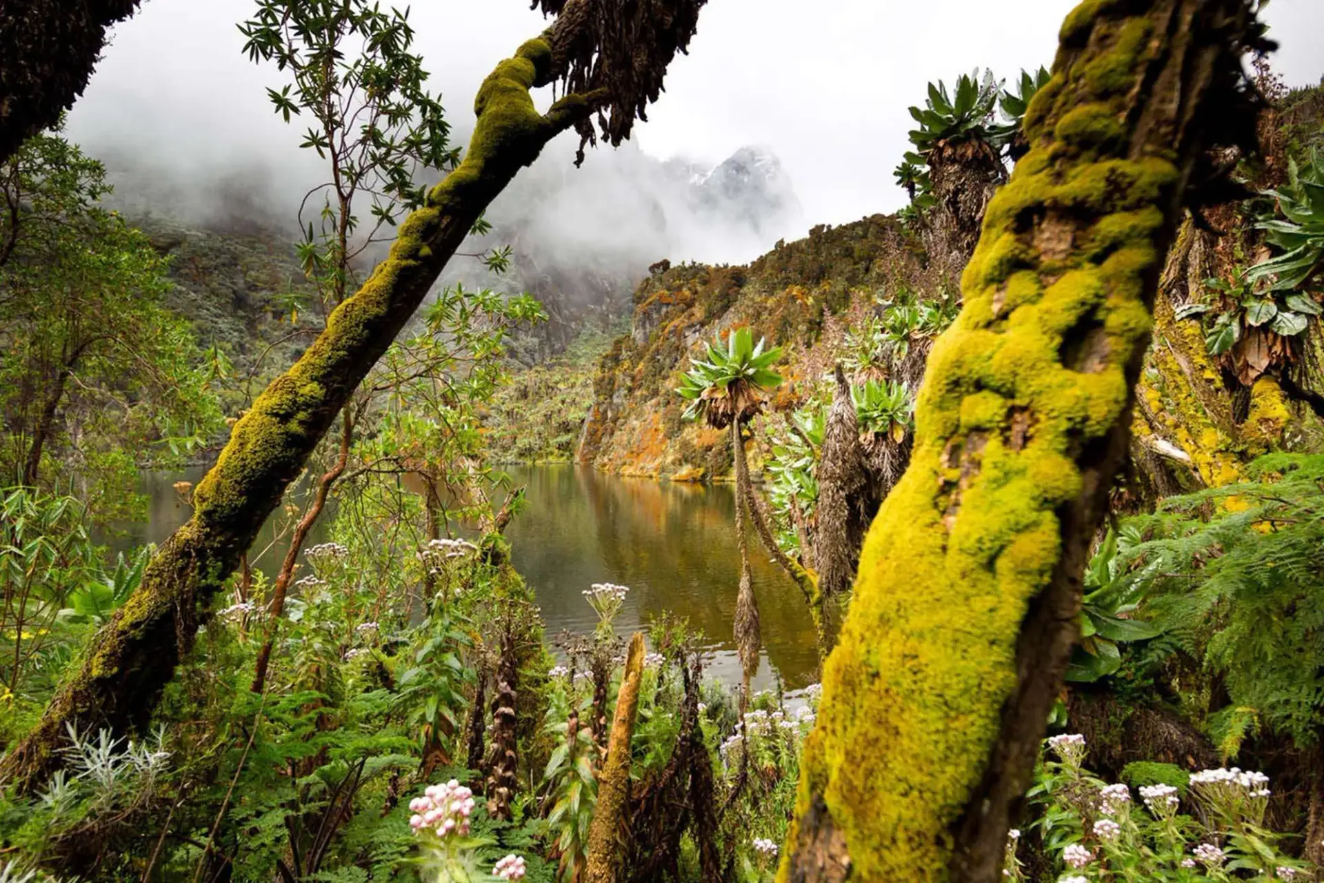
One of the best-kept secrets in the Rwenzori is Lake Mahoma. Because Margherita Peak and the summit glaciers get all the attention in Ugandan trekking guides, the amazing lower and mid-mountain environment, the bamboo belt, the montane forest, and the ancient moss-covered heather trees never make it into the tourism press. To get a feel for this subterranean realm, nothing beats the Mahoma Loop. Set in a crater basin with steep sides at an altitude of 2,990 meters, the lake is an immaculately created glacial tarn. When the mornings are quiet, the sea is dark, frigid, and perfectly still. In fact, the forest practically reaches the water’s edge. Aside from the sound of birdsong, water, and wind, there are no signs of any other visitors or tents in the area.
One of the most important biodiversity hotspots in Africa is the Rwenzori Mountains National Park, which is also a UNESCO World Heritage Site. Over two hundred bird species call the lower woodland zone along the Mahoma Loop home. Among these are nineteen species that are unique to the Albertine Rift. It is considered by serious birdwatchers to be one of the best places on the continent to see birds. A living habitat untouched by human development, the lush forest, towering Podocarpus trees, waterfalls heard from the trail, colobus monkeys in the sky and the continual, layered sound of the water’s fall will amaze even the most casual visitor.
The 3-Day Mahoma Loop Hike never gets you into the altitude zone where you have to worry about acclimatisation; the highest elevation it gets you is 2,990 meters. Crampon training, glacier gear, and altitude medication are not necessary. This means that it can actually accommodate a considerably broader variety of tourists compared to the summit routes, including hikers of a more advanced age, people who aren’t used to multi-day hikes, and those who are more interested in seeing the animals in Uganda than in climbing. The Mahoma Loop is recommended as the best way to begin hiking the Rwenzori as a beginner, according to our guide.
The Mahoma Loop is a great shakedown path for seasoned hikers thinking about a longer adventure. Experience the true Rwenzori conditions—rain, mud, steep forest terrain, and primitive hut accommodation—for three days on the mountain before committing to the 7-Day Margherita Peak Climb or any of the summit itineraries. This will give you a true image of what to anticipate. Many tourists who have been here before have done the same thing: climbed to the peak within a year of completing the Mahoma Loop.
A Detailed 3-Day Mahoma Loop Hike Itinerary
Day 1: Nyakalengija Gate to Nyabitaba Camp
Nyabitaba Camp (2,652 m) | Entry into the Rwenzori Forest World
Elevation: 1,646 m to 2,652 m (+1,006 m) | Distance: ~8 km | Hiking Time: 4–5 hours
The Mahoma Loop starts at Nyakalengija Gate, which is about 22 kilometres northeast of Kasese town and is the main entrance point for the Rwenzori Central Circuit. The gate is 1,646 meters high and is maintained by the Uganda Wildlife Authority. You will enter the forest just after 8:00 in the morning after registering at the ranger post, meeting your porter crew and guide, and distributing loads. The path that lies ahead is unlike any other mountain approach in East Africa; it is thick, muggy, close, and full of noise.
Along a well-kept dirt road, the hike begins with a moderate ascent through tropical lowland vegetation. The upper storey is provided by Symphonia globulifera, Podocarpus latifolius, and Newtonia trees, and the understory is teeming with ferns, wild balsams, and an astounding variety of epiphytic plants that cling to any and all surfaces. The canopy above is lush and layered. The forest floor steams softly in the morning humidity as light penetrates through the canopy in slanted beams.
After around 90 minutes of hiking from the entrance, you will cross the Mubuku River on one of many log bridges. For the better part of an hour in the morning, you are accompanied by the churning, icy, white river. Upon crossing the river, the trail begins to ascend through a more towering forest, with a more verdant understory, as the altitude rises. The Rwenzori turaco (Ruwenzorornis johnstoni) is a magnificent bird with red wing feathers that is unique to this mountain range. Keep an eye on the canopy here because it is a prime habitat for this bird. You will often see families of black and white colobus monkeys leisurely making their way through the trees in the higher canopy areas.
Continuing through the most wooded part of the lower path, the last 45 minutes to Nyabitaba Camp include climbing a notable forest ridge. At 2,652 meters, you come out of the forest onto a saddle, and through the trees you can see the camp’s metal-frame cabin. When the afternoon clouds part, you can see all the way to the plains below from the camp ridge, and on clear nights you can even make out Queen Elizabeth National Park and Lake George in the distance. When you and your culinary crew arrive, a hot meal will be waiting for you. Prior to the next day’s push to the lake, the afternoon is dedicated to rest, birding on the camp ridge, and acclimating to the chilly mountain air.
Day 2: Nyabitaba Camp to Lake Mahoma Camp
Lake Mahoma, 2,990 m | The Crater Lake at the Heart of the Forest
Elevation: 2,652m to 2,990m (+338m) | Distance: ~11 km | Hiking Time: 5–6 hours
The second day of the Mahoma Loop is the most memorable for most hikers because it is where the loop begins and ends. As it leaves the lower forest and enters the ancient tree heather zone that characterises the visual character of the Rwenzori, the trail from Nyabitaba to Lake Mahoma goes through a botanical world that is both more bizarre and more beautiful. Start your day at approximately 7:30 in the morning after you have breakfast. Before taking a left onto the Mahoma Forest Trail to the northeast, the trail begins its descent from the Nyabitaba ridge and returns to the Mubuku River valley.
Approximately 2,500 to 2,600 meters is the altitude at which you will be traversing throughout the first hour of the day. Lower woodland species give way to the distinctive Rwenzori heather-dominated vegetation, a noticeable change in the flora. Like a scene out of a primordial world, the trail is lined with Erica arborea trees, which are covered in deep-pile moss and pale green hanging lichen. The Rwenzori’s moss cover is exceptionally thick and uniform, reaching depths of 20 to 30 centimetres and encasing even individual boulders, tree roots, and fallen logs. It is very unearthly to go through this zone.
In the first part of the day, you’ll ascend through a bamboo zone, where huge mountain bamboo (Sinarundinaria alpina) stands produce an optical illusion of a bamboo cathedral with their arching culms. Afterwards, you’ll emerge into more open heather moorland. The trail that leads down into the lake crater starts here. One of the most rewarding parts of the hike is cresting the 200-meter descent into the crater basin and seeing the black surface of the lake peeking out from behind the trees.
At an elevation of 2,990 meters, Lake Mahoma is located in a perfectly round glacier crater, and an old heather forest encircles the lake on all sides. The depth of the lake is 30 meters, and its diameter is about 300 meters. As one would expect from a high-altitude lake with tannic drainage from heather roots, the water is a deep tea colour. When the air is quiet on mornings, it reflects the sky and trees beyond like a mirror. Little waves crash on its shores on windy afternoons. Many aquatic bird species, including mountain ducks and different waders, as well as a tiny population of high-altitude fish, call the lake home.
The Lake Mahoma campsite is one of the most picturesque spots for a night on the Rwenzori Trail, set on a little, level space right on the water’s edge. There is a direct view of the water from the hut. As the sun sets, dinner is served, and stars reflected in the lake provide for a breathtaking sight if the clouds part for the night. Nighttime lows at the lake will be 8 to 12 degrees Celsius, far lower than Nyabitaba. You must have a dry set of camping clothes and a comfortable sleeping bag.
Day 3: Lake Mahoma Camp to Nyakalengija Gate (Loop Descent)
Nyakalengija Gate 1,646m | Completing the Loop
Elevation: 2,990m to 1,646m (-1,344m) | Distance: ~16 km | Hiking Time: 5–7 hours
The last day of the Mahoma Loop covers the most ground physically, but mentally, it’s easier than the other two because the terrain is so relentlessly downhill. By 7:30 in the morning, after a hearty meal and an early morning lake session, the crew sets out on the loop trail that, instead of taking the same ridge that went up, goes down from the lake crater. What makes the loop design unique is that on Day 3, you get to visit a completely different part of the Rwenzori forest than the part you saw on the way up.
Starting with a short ascent out of the crater on the southern side, the descending trail from Lake Mahoma begins a lengthy, steady drop through thick montane forest. The forest is noticeably rougher and wildlife interactions are often more frequent because this segment travels through less-traveled territory than the main Nyabitaba trail. Here the trail is narrower, rootier, and much muddier than the main path. On this descent, rubber boots really come in handy.
At about the halfway point of the day’s walk, you’ll cross a number of streams using log bridges as you make your way through an especially verdant area of lower heather and bamboo forest. The Rwenzori batis, the attractive francolin, the double-collared sunbird, and the African hill mynah are among of the smaller woodland birds that are most commonly seen in this part of the loop. While perusing the edges of the bamboo forest, keep an ear out for olive sunbirds and the unique call of the Rwenzori white-tailed flycatcher.
The track descends back into the Mubuku Valley’s tall-canopy tropical forest, following the river downstream until it meets up with the main Central Circuit trail about three kilometres from the gate. As you near the end of your journey along the valley floor, you’ll be greeted with the comforting sounds of the river, a shift in the humidity and light as the forest canopy opens, and your first glimpse of the Nyakalengija Gate buildings peeking out from behind the trees. Those who make it around the entire circle will receive a summit certificate from the UWA rangers. The gate is where your transfer van will leave for Kasese or wherever you are going next.
End of the 3-Day Mahoma Loop Hike Itinerary