7-Day Rwenzori Trek to Margherita Peak via Central Circuit
The 7-day Rwenzori trek to Margherita Peak (5,109m) is an exhilarating, high-altitude alpine expedition. Starting in Nyakalengija, it guides you through five distinct vegetation zones. The intense final climb requires crampons and ice axes to cross glaciers and fixed ropes on Mount Stanley.
Experience the 7-Day Rwenzori Trek to Margherita Peak via Central Circuit. High summit success rates, professional guides, glacier crossings, and comprehensive logistics make this the most difficult trip in Africa. Take the first step in organising your adventure now.
The third-highest peak in Africa, Margherita Peak, is reached in the shortest amount of time (only seven days) on this fully guided trip. The Rwenzori Mountains are home to this peak. With its thick rainforest, high bogs, steep valleys, and tropical glaciers, the Rwenzori is a genuine climbing habitat, distinct from conventional high-altitude excursions. Those in good physical condition who seek more than just a summit ascent might choose this route. The ascent takes you on a thrilling journey across a mountain range that is unlike any other on the planet.
Kilimanjaro is nothing compared to this peak. The Rwenzori is not a race that rewards quickness but rather steadiness, balance, and perseverance. The payoff is an expedition-style climb that is far less crowded and more distant, technical, and spectacular.
Among the Rwenzori Mountains, trekkers can find Margherita Peak, the highest point in the range, after a seven-day ascent from Nyakalengija. The route taken by this Rwenzori trekking group is the Central Circuit Trail.
This 7-Day Rwenzori Trek to Margherita Peak via Central Circuit trail begins in Nyakalengija and continues through Nyabitaba, John Matte, Bujuku, Elena, Mount Stanley (Margherita Peak), Kitandara, and Guy Yeoman. The elevation range of the trail is 2,800 to 5,109 meters above sea level. Mountain valley, alpine zone, bamboo zone, and mountain forest are the five distinct vegetation zones you’ll encounter on your journey.
Getting to Margherita Peak, the highest point of the major circuit path, requires hiking through five different types of vegetation. Your Rwenzori mountaineering adventure will begin in Kasese and last seven days.
Why Choose the 7-Day Rwenzori Trek to Margherita Peak?
There are three significant summits in Africa. While Kilimanjaro is at 5,109 meters, Margherita Peak in the Rwenzori sits at 3,099 meters, making it one of the continent’s most under-climbed significant summits. Rwenzori is reached by less than 1,500 hikers every year, in contrast to the over 50,000 who tackle Kilimanjaro. You know you’re in for an adventure unlike any other mountain hike in Africa by the stark contrast: remote, wild, technically challenging, and unlike any other.
The best-known and longest-running ascent route is the 7-Day Rwenzori Trek to Margherita Peak. From its starting point at Nyakalengija, the trail winds its way up the Central Circuit Trail, a 58-kilometer loop that passes through five different biological zones en route to the Stanley Plateau and the glaciated last approach to Margherita. At this altitude, a stroll is far from easy. A perpetual cloud forest encircling equatorial glaciers, the Rwenzori is best explored over the course of seven days, allowing your body and mind to acclimatise and absorb the sights and sounds along the way.
In terms of time, this path is slower than an alternative that takes five days. The Bigo Bog deserves some time to linger. In the upper alpine zone, there are senecio groundsel and three-meter enormous lobelias that need to be studied. On Day 4, we should be able to reach Elena Hut beneath the glacier with sufficient energy for the summit push the following morning at 2:00 a.m. The additional days are not filler; rather, they are the deciding factor between simply making it up the mountain and truly appreciating its beauty. See our 6-day vs.7-day route breakdown for a direct comparison of time-on-mountain choices.
The Rwenzori Mountains are home to species that are unique to this region and have earned UNESCO World Heritage status. Scientists predict that unless there is a drastic change in climatic patterns, the remaining tropical glaciers in Africa may vanish totally by 2040, and this range is home to just that. You will be one of the last generations to set foot on African equatorial ice when you ascend Margherita Peak today. That is not the language of marketing. This climb takes on an extra sense of urgency due to a well-documented scientific fact. Our report on the retreat of the Rwenzori glacier has the whole story.
A Detailed 7-Day Rwenzori Trek to Margherita Peak Itinerary
Day 1: Nyakalengija (1,600 m) to Nyabitaba Hut (2,652 m) | 8 km | 4-5 hours
The small trade center of Nyakalengija, located on the lower slopes of the range outside of Kasese, is where your excursion begins. It is home to the Rwenzori Mountaineering Services (RMS) headquarters. Register at the Uganda Wildlife Authority gate and enter Rwenzori Mountains National Park after a comprehensive briefing, kit check and porter assignment. Before the valley market sounds completely disappear, the lower route meanders through Bakonzo fields and homesteads.
During the initial hours, you will be immersed in a dense highland rainforest. Gaining height through a thicket of fig trees, wild ginger, and ferns soaking with wetness, elephant grass looms overhead. One of the most abundant bird habitats in Uganda is this lowland forest. Be on the lookout for the red-throated turaco of Rwenzori, the long-eared owl skulking in the treetops, and the Archer’s robin-chat and Rwenzori batis in the understory. In addition to the black-and-white colobus monkeys that cross the trail regularly, forest elephants still make their way across these lower slopes.
The ascent on Day 1 is deliberate and gradual, never harsh. As your body adjusts to the elevation change from 1,600 m to 2,652 m, pushing yourself too hard on day one will lead to fatigue by day two. Among Uganda’s mountain huts, Nyabitaba Hut offers one of the best views of the lowlands and Queen Elizabeth National Park on clear evenings, as it sits on a ridge above the Bujuku and Mubuku valleys. The mountain becomes silent as dinner is served and morning equipment is examined.
Day 2: Nyabitaba Hut (2,652 m) to John Matte Hut (3,380 m) | 11 km | 5-6 hours
Kurt Shafer Bridge, an iron suspension bridge across the turbulent junction of the Bujuku and Mubuku rivers, is reached after a hot breakfast as the trail descends sharply from the Nyabitaba hill. As soon as you cross the bridge, the mountain takes on a completely new personality. Huge heather trees, their roots partially immersed in the perpetually wet ground, are visible when the path reaches a zone covered in lichen and moss. At this point, wearing rubber boots is absolutely necessary.
During the middle of the morning, you’ll go by the Nyamulejju Rock Shelter, a natural ledge that has served as both a lunch stop and an overnight camp on previous excursions. From here, you can get your first real idea of the trail’s intended destination—on clear days, you can see the tops of Mount Stanley and Mount Speke above the treeline. The afternoon carries on through a deep forest and bamboo forest until the valley opens up at 3,380 m, where John Matte Hut is located on the banks of the Bujuku River.
For most hikers, the first taste of altitude comes at John Matte. A little loss of appetite, disturbed sleep, and notably thinner air compared to home are all possible side effects. You can easily control and manage all of these symptoms. Get your fill of water—at least three liters—and eat a complete dinner without obsessing over every symptom. At this point, relaxation, hydration, and self-assurance are the greatest ways to deal with mild altitude symptoms.
Day 3: John Matte Hut (3,380 m) to Bujuku Hut (3,960 m) | 5 km | 4-5 hours
As we move from the mountain forest into the Afroalpine zone on Day 3, the distance is shorter but the spectacle is richer. The trail heads into the lower Bigo Bog after crossing the Bujuku River. This is a huge saturated valley surrounded by rocky slopes. Jumping from tussock to tussock in knee-deep water, this bog was formerly said to be the most demanding kilometre in African mountaineering. While the most treacherous parts of the Central Circuit Trail are now encased in a wooden boardwalk, the scenery still ranks among the most surreal.
Starting in the valley, you’ll see gigantic lobelias that may reach a height of four meters and produce flower spikes shaped like cones. As they sway in the mist, giant groundsels like candelabras from primordial times. In just a few vertical kilometres, the five vegetation zones of the Rwenzori compress altitude bands that extend hundreds of kilometres elsewhere in Africa. At 3,960 meters, Bujuku Hut offers breathtaking views of Mounts Speke, Baker, and Stanley and has been a popular stopping point for explorers since Ptolemy’s ancient description of the range. The hut sits on the border of Lake Bujuku and provides easy access to the rest of the range.
Day 4: Bujuku Hut (3,960 m) to Elena Hut (4,541 m) | 3 km | 4-5 hours
Day 4 isn’t long in mileage, but it’s really taxing. Every hour spent resting in Elena Hut has a direct correlation to how well you do tomorrow morning at the summit, and the altitude is starting to have a noticeable physiological impact. The trail starts in Bujuku and ascends across the difficult moraine terrain above Lake Bujuku. It then descends into the Scott-Elliot Pass area, a boulder field that demands precise foot placement and, at its steepest point, the use of fixed metal ladders. Trekkers without prior scrambling experience may find this initial stretch of the path daunting; however, your guide will ensure that the team is positioned correctly.
The trail that heads right at the fork just below the pass climbs steeply over big rocks in the direction of Elena Hut and Mount Stanley. The highest camping spot on the whole trek, Elena Hut, is located at 4,541 m on the rocky western shoulder of Mount Stanley. As you step out of the hut, you’ll be greeted by views of the Stanley Plateau glacier, Mount Baker, and Mount Speke over the Bujuku Valley. Your summit briefing tonight will cover everything from glacier technique and time to crampon fitting and ice axe use. Go to bed no later than 7:30 in the evening.
Day 5: Summit Margherita Peak (5,109 m), Descend to Kitandara Hut (4,023 m) | ~10 km total | 10-12 hours
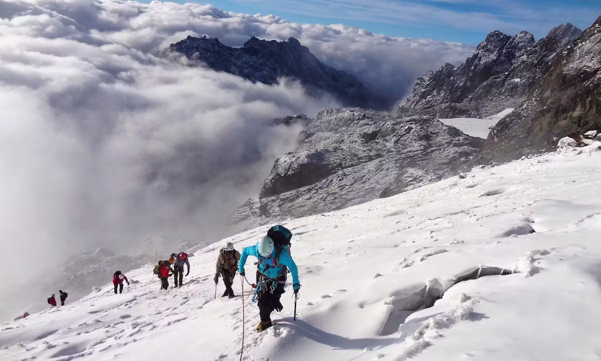
The adventure will be defined by this day. Get up and get moving at two in the morning. From Elena Hut, your guide will use a headlamp to guide you across treacherous scree as you prepare to put on crampons at the edge of the glacier just before 3:30 in the morning. A large, crevassed ice field, the Stanley Plateau Glacier can be navigated using fixed ropes and the line your guide has selected. Temperatures of -10 to -15 degrees Celsius are common at this elevation just before sunrise, and the presence of any wind makes them feel much colder. This is when your layering strategy really shines. In case you’re still confused about what to bring, our summit layering guide has you covered.
Above the Stanley Plateau, on the steeper ice of the Margherita Glacier, one must use crampons and one or two rope pieces while front-pointing. While you watch, your guide fastens the team to the rope and shows each procedure. Although it does not include alpine-style technical mountaineering, it does need physical exertion and mental stability at high altitude. Between seven and nine in the morning, the majority of hikers make it to the top of Margherita Peak. You have arrived at Africa’s third-highest peak, where there is virtually no one else in sight; the summit register; the ice underfoot; the view stretching from the Democratic Republic of the Congo to the plains of western Uganda; and the certainty that this is all you came for.
It takes two or three hours to descend to Elena Hut after taking pictures at the peak and absorbing the view. After enjoying a hearty lunch, the crew heads south, crossing Scott-Elliot Pass (4,372 m) on their way to the twin Kitandara Lakes. One of the most breathtaking parts of the entire journey is this afternoon’s traverse, which entails walking over a high ridge above turquoise glacial lakes as Mount Baker’s south face dominates the horizon. Rest and supper at Kitandara Hut.
Day 6: Kitandara Hut (4,023 m) to Guy Yeoman Hut (3,261 m) | ~10 km | 6-7 hours
Today marks the beginning of the descent, and as expected, the atmosphere in the group always improves. The cumulative altitude exhaustion begins to transform into a subtle contentment after reaching the top, and bodies begin to feel lighter. Starting from Kitandara, the trail winds its way around the southern flank of Mount Baker, a treacherous stretch of rough, steep terrain that demands careful footing. After a short ascent to Freshfield Pass (4,282 m), the trail heads down the Mubuku Valley, occasionally slipping as it does so, to the Guy Yeoman Hut.
The Duke of Abruzzi’s base camp during his legendary 1906 first climb of Margherita Peak was the rock shelter at Bujangolo, which is passed on the descent. As you stand here, surrounded by the same moss-covered rocks that provided shelter to a renowned Alpine explorer in the early 1900s, the mountain’s history comes alive. At an elevation of 3,261 meters, Guy Yeoman Hut is located on the banks of the Mubuku River and is much warmer and more oxygen-rich than the high camps. Usually, this is where you can get the best rest of the week while you sleep.
Day 7: Guy Yeoman Hut (3,261 m) to Nyakalengija (1,600 m) | ~14 km | 7-8 hours
The last day consists of a lengthy descent into the lower montane zone across a bamboo grove. On the way down from Guy Yeoman to Nyabitaba, hiking poles are useful because to the muddy path and occasionally slippery terrain. A three-hour descent brings you back to Nyakalengija, the same trailhead from which the trip started seven days earlier, after a break and lunch at Nyabitaba.
Upon your return to Nyakalengija in the late afternoon, remember to tip your porters, return any equipment that you rented, and, if you were successful in reaching Margherita Peak, collect your summit certificate. The majority of hikers then spend the night in the town of Kasese before continuing their journey. If you still have time in Uganda, you should definitely add a wildlife safari to your itinerary at Queen Elizabeth National Park or a gorilla hike to Bwindi Impenetrable Forest National Park—both are just a few hours’ drive away.
End of the 7-Day Rwenzori Trek to Margherita Peak Itinerary