6-Day Rwenzori Trek To Margherita Peak via Central Circuit
The 6-Day Rwenzori Trek To Margherita Peak (5,109 m) in the Rwenzori Mountains is a demanding, highly technical alpine expedition requiring glacier crossing and rope work. Starting from Nyakalengija, this shorter itinerary requires high physical fitness and acclimatization to summit Africa’s third-highest peak within a compressed timeframe.
Climb Africa’s third-highest mountain in just six days on the Rwenzori Margherita mountain Trek, part of the Central Circuit on Rwenzori Trekking Safaris. The 6-Day Rwenzori Trek To Margherita Peak takes you through a unique ecosystem unlike any other mountain on the continent, taking you from a tropical rainforest to glaciated alpine ranges. This is the Rwenzori at its most engrossing: the ideal combination of speed and awe, of ambition and acclimatisation.
Reach Margherita Peak, Africa’s third-highest peak, during an exciting and spectacular 6-Day Rwenzori Trek To Margherita Peak. Climbing Mount Stanley requires navigating through a variety of ecosystems en route to the peak. With proper preparation for the technical parts of the climb and adequate time to acclimatise, you can reach the peak in six days without experiencing altitude sickness.
Find out about the thrilling 6-Day Rwenzori Trek To Margherita Peak, perfect for hikers of any skill level who want to reach the peak of Mount Stanley. The Central Circuit Trail meanders through verdant woodlands and leads to the alpine region in the glacier portions of Mount Rwenzori. In the Rwenzori Mountains, you will encounter a wide variety of flora and fauna, and you will also embark on an exciting journey. Upon reaching Margherita Peak, the last destination, hikers are greeted with stunning panoramas. Due to the emotionally and physically taxing nature of the program and the long days of walking, hikers are advised to begin their journey early.
Embark on a thrilling 6-Day Rwenzori Trek To Margherita Peak (5,109 m), the loftiest peak on Mount Stanley in the world-famous Rwenzori Mountains of Uganda. A strenuous but ultimately rewarding trip through one of Africa’s most distinctive ecosystems, this adventure is suitable for hikers of varying abilities. Unspoiled mountain streams, unique plant species, and panoramic vistas that few have witnessed are all throughout the Central Circuit.
A sense of achievement and the pristine beauty of the Rwenzori Mountains await you at the end of the 6-day Rwenzori journey, which requires early starts, endurance, and resolve, particularly as you near the glacier-covered peak of Margherita.
Why Choose the 6-Day Rwenzori Trek To Margherita Peak?
If you’re looking for a middle ground between a fast and rigorous 4-day sprint and a leisurely 7-day excursion to Margherita Peak, the 6-Day Rwenzori Trek To Margherita Peak via the Central Circuit Trail is a great choice. You may complete the circuit in a timeframe that works for most working travellers and still get some meaningful acclimatisation time above 4,000 meters, giving your body the chance to adjust and allowing you to truly experience the bizarre high-altitude scenery. If you want to climb Mount Stanley in comfort and confidence, you need give yourself at least six days.
Among Africa’s mountain ranges, the Rwenzori are completely unique. Unlike Kilimanjaro, a wide volcanic cone that some 50,000 hikers climb every year, the Rwenzori gets less than 1,500 visitors, so you won’t have to worry about sharing the trail with many others. The mountain is truly remarkable for its scientifically remarkable flora zones, which range from dense montane forest to enormous heather, strange Afro-alpine moorland, and finally, naked glacier ice, all within a single walk. This is why the mountain has been designated as a UNESCO World Heritage site.
The addition of Kitandara Lakes on Day 4 is what really makes the 6-Day Rwenzori Trek To Margherita Peak version stand out. One of the most picturesque post-summit rewards in African mountaineering is descending past the twin Kitandara Lakes, shimmering blue at 4,027 m amid a world of rock and mist. This comes after summiting Margherita Peak in the pre-dawn darkness and standing on the roof of Uganda with the Congo Basin spread below you. On Day 5, you’ll traverse Freshfield Pass and continue along the historic trail, which will lead you past the base camp of the Duke of Abruzzi from 1906 at Bujongolo rock shelter. This will bring you face-to-face with the mountain’s extraordinary history of exploration.
Over the past century, the Rwenzori glaciers have shrunk by more than 80%, and by 2050, experts anticipate that all of the ice will have melted. There is a brief window of opportunity to cross an equatorial glacier off your list of must-dos. The most effective way to stand on that glacier and return changed is the 6-Day Rwenzori Trek To Margherita Peak.
6-Day Rwenzori Trek To Margherita Peak Itinerary
Day 1: Nyakalengija (1,600m) to John Matte Hut (3,420m) | ~12 km | ~7–8 hrs
At an elevation of 1,600 meters on the range’s eastern sides, you’ll find Nyakalengija, the park entrance point, where your Rwenzori experience starts. Gather your rubber boots—required footwear on the Rwenzori—here after hearing the park briefing from rangers from the Uganda Wildlife Authority. Then, meet your lead guide and porter crew, and get ready to venture into the bush.
Prior to plunging into one of the most pristine montane forests in equatorial Africa, the trail spends the first hour winding through farmed terrain on a broad, gradually ascending slope. Overhead, the canopy seals. The turaco’s cries reverberate through the underbrush. A heavy, verdant, and chilly air settles in. Around the 3-kilometer point, you’ll arrive at Nyabitaba Hut (2,652 m), the initial campsite on the Central Circuit, where a lot of hikers with shorter routes spend the night. Here you will take a lunch break and continue with the 6-day plan.
In order to reach the Kurt Schaffer Bridge—a magnificent wooden span across the Bujuku and Mubuku rivers—the trail now drops precipitously. After that, it climbs steeply into the bamboo zone. A wilder, more primal nature emerges as the woodland gives way to taller, rootier, and muddier ground. John Matte Hut (3,420 m), situated above the river and encircled by tree-heather adorned with hanging lichens, is reached after navigating difficult stretches of the Bujuku River. A hearty meal and some much-needed sleep.
Elevation gain: approx. +1,820m. Terrain: forest path, bamboo zone, river crossing, rocky riverbank. Sleep: John Matte Hut. Meals: Packed lunch on trail; hot dinner at hut.
Day 2: John Matte Hut (3,380m) to Bujuku Hut (3,962m) | ~8 km | ~5–6 hrs
The Rwenzori’s extraterrestrial nature is revealed on Day 2. After breakfast, the trail heads out of John Matte Hut and crosses the Bujuku River. Eventually, you’ll reach the Lower Bigo Bog, a huge wet valley covered in three- to four-meter-tall enormous lobelias (Lobelia wollastonii). You might walk on a wooden walkway through this otherworldly setting, but you can be sure that your boots will end up in the bog no matter what. Wearing rubber boots is an essential component of the Rwenzori experience due to the famed mud.
Upon reaching the Upper Bigo Bog, one must ascend a steep, forested path that leads directly into the Bujuku Valley, the beating center of the Central Circuit. Here the scenery changes in scale: the valley is wide and open, the sky is huge, and you can see Mount Baker (4,843m) and Mount Stanley (4,843m), which are usually shrouded in cloud, towering to the south and west, respectively. Just before the cabin, you can see Lake Bujuku, a high-altitude, glassy lake surrounded by steep slopes.
Several important paths converge at Bujuku Hut (3,962m). As a base camp, trekkers utilise the cabin to try Mount Speke (4,890m). Acclimatise, drink plenty of water, and relax at the hut tonight before tomorrow’s big push.
Elevation gain: approx. +580m. Terrain: valley bog, boardwalk, open alpine moorland. Sleep: Bujuku Hut. Meals: Breakfast and dinner at huts; packed lunch on trail.
Day 3: Bujuku Hut (3,977m) to Elena Hut (4,430m) | ~5 km | ~4–5 hrs
Today is the day you will prepare for the summit; unlike the days leading up to and following, it will be shorter and less strenuous. The trail ascends from Bujuku Hut along a tall forest of enormous groundsels (Senecio adnivalis), gigantic, extraterrestrial-looking plants, until the narrow and steep valley that lends the name “Groundsel Gully” narrows.
Upon reaching the peak of the ravine, the path divides. The Central Circuit path culminates in Scott Elliot Pass, which you are presently approaching at 4,372 m. As you look out from the pass on a clear day, you can see the Bujuku Valley receding into the distance, Mount Baker rising to the south, Mount Luigi de Savoia standing to the northwest, and the Stanley Plateau glacier shimmering above.
To reach Elena Hut at 4,430 m, the trail descends from Scott Elliot Pass before ascending again across steep and frequently cold terrain. Situated on a ridge high above the glacier, the little hut is vulnerable to the cold and wind. The starting point for tomorrow’s ascent is here. Gather all of your technical summit gear with your guide, have a hearty dinner before bed, set your alarm for 3 in the morning, and get as much sleep as you can.
Gain in elevation: around 450 meters net. Path portions near the cabin are ice, and the terrain varies from steep groundsel woodland to rocky alpine peak. Elena Hut Slept. Meals: Bujuku for breakfast and Elena for a nice supper.
⚠ Guide Warning: Your guide will fit you with your harness, glacier gear, and crampons (if conditions require) this evening. Ask any technical questions tonight. Once you are on the Stanley Glacier at 4,500 m in the dark, you want no surprises.
Day 4: Elena Hut (4,541m) → Margherita Peak (5,109m) → Kitandara Hut (4,027m) | ~14 km | ~12–14 hrs total
Now is the time. The day of the summit. At three in the morning, you’ll hear the alarm go off, and by three and a half, you’ll be prepared to climb the Stanley Glacier under the light of your headlamp, having been roped up previously. As dawn approaches, the temperature drops to below freezing and there is complete quiet save for the sound of crampons crunching on the snow and ice.
Depending on your pace and the weather, climbing Margherita Peak might take anywhere from five to seven hours. Prior to the last difficult ascent to the peak, the trail traverses the Stanley Plateau, a wide, crevassed glacier situated at around 4,900 m. There are parts of exposed rock and ice that necessitate the use of fixed lines and your guide’s explicit guidance. It is technically challenging, but the payoff is really spectacular.
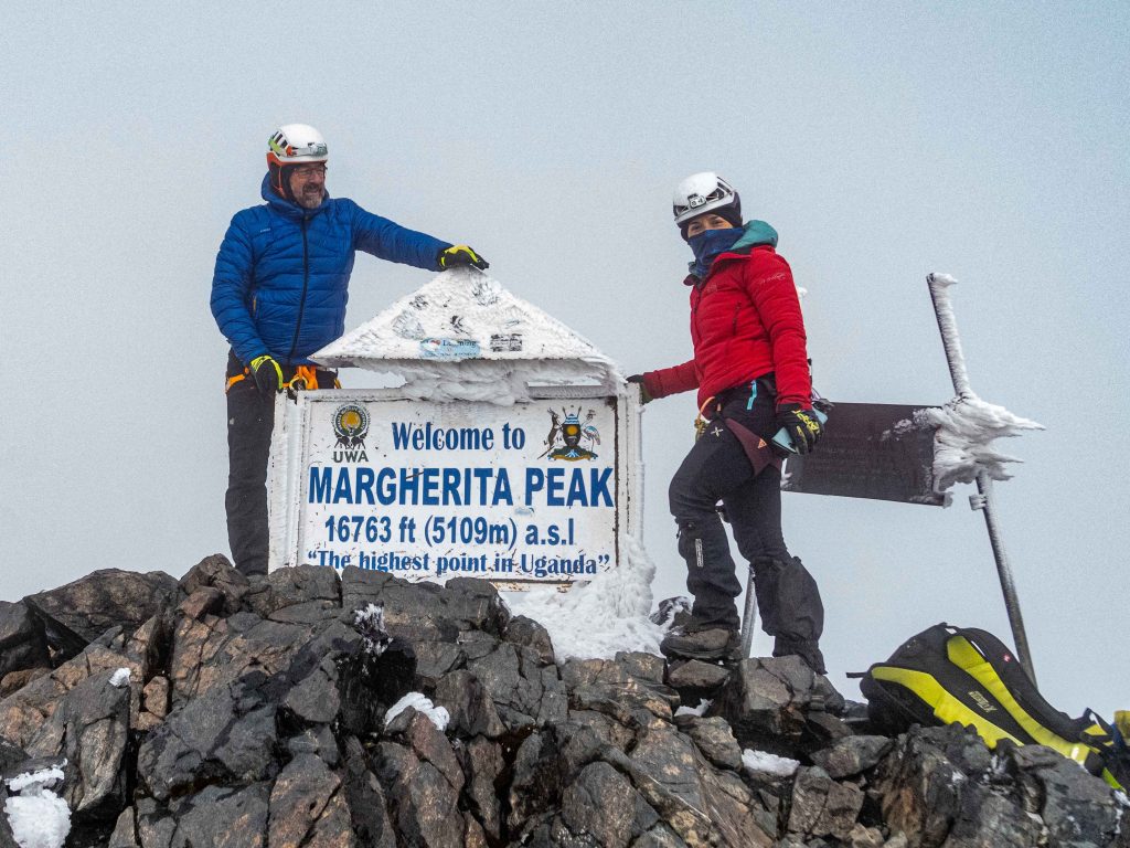
The third-highest peak in Africa, at 5,109 meters, is Margherita Peak, following Kilimanjaro and Mount Kenya. One of the incredible rewards of travelling to Africa is the opportunity to stand atop the mountain and take in the sunrise panorama, which includes the Congo Basin to the west, the Ugandan plains to the east, and a cluster of other Rwenzori peaks below. This reward is yours for the taking.
The descent starts after taking shots of the summit and a short break. After retracing your steps on the glacier to Elena Hut, you’ll gather your packed lunches and set off on the long descent to Kitandara Hut (4,027m), which is situated opposite the world-famous Kitandara Twin Lakes and reached after descending Scott Elliot Pass and the Bujuku Valley side. One of the most breathtaking mountain campsites is situated between these two immaculate glacial lakes, bordered by rugged alpine peaks. A meal here is definitely warranted.
The entire elevation change from Elena to the top is 568 meters, while from Kitandara it is 2,082 meters down. Landscape: rocky alpine, moorland, snow, ice, and glaciers. The Kitandara Hut is the place where you can nap. Lunch on the way down, dinner in Kitandara, and a hot breakfast at Elena (start time: 3:00 AM; light snack before departure) follow.
📊 Success Rates: The Rwenzori summit success rate is high when trekkers are properly acclimatized and guided. Read our dedicated page on summit success rates to understand what most influences your outcome.
Day 5: Kitandara Hut (4,027m) to Guy Yeoman Hut (3,450m) via Freshfield Pass (4,282m) | ~10 km | ~6–7 hrs
Day 5, following the thrill and fatigue of summit day, is a lengthy but worthwhile journey. Ascending the magnificent headwall above the lakes, the trail from Kitandara Hut swiftly climbs the southern face of Mount Baker, reaching Freshfield Pass at 4,282m, the toughest ascent of the descent portion, which starts in the morning. Even though it’s a steep hike, the views of the Kitandara Lakes from higher up are worth it.
Following a descent from the pass, one reaches Bujongolo Rock Shelter, the famous base camp utilised by the Duke of Abruzzi during his 1906 first ascent expedition. The terrain consists of cushion plants, everlasting flowers (Helichrysum sp.), and dwarf heathers. You can find a plaque there. One of those peaceful moments of connection that gives mountain travel meaning is standing here, protected by the same overhang that housed the duke’s porters more than a century ago.
Resting in a clearing with expansive views of the valley, Guy Yeoman Hut is reached at 3,450m after a difficult descent through heather forest. Tonight is the last night you will spend on the mountain.
Elevation: +255m to pass; -832m descent to the hut. Terrain: steep rocky headwall, high alpine mossy trail, and heather forest. Sleep: Guy Yeoman Hut. Meals: Breakfast and dinner at huts; packed lunch on trail.
Day 6: Guy Yeoman Hut (3,450m) to Nyakalengija (1,600m) | ~14 km | ~6–7 hrs
The last day takes you down into the Mubuku Valley, a lengthy, muddy, and occasionally steep path that demands cautious walking but brings you down from the mountain with one last look at the lower-altitude grandeur of the Rwenzori. The path continues downstream along the Mubuku River after navigating the Kichuchu cliffs. It crosses the river twice using stepping-stone pathways through swampy terrain. As if it were a ritual, stepping on a tussock will result in a boot full of Rwenzori bog.
Following the fords of the rivers, you’ll make a short ascent to Nyabitaba Hut (2,652 m), a nostalgic landmark where you had lunch on Day 1. From there, you’ll descend through the montane forest, passing Mihunga Gate en route to the trailhead at Nyakalengija. Once you’ve signed the park’s exit register and received your certificate (if applicable), a car will take you back to Kasese, where you can enjoy a hot shower, a cold drink, and a properly cooked supper.
Elevation loss: approx. -1,850m. Terrain: muddy valley path, river crossings, montane forest descent. Meals: Breakfast at hut; lunch at Nyabitaba; transfer to Kasese.
End of the 6-Day Rwenzori Trek To Margherita Peak Itinerary