4-Day Rwenzori Waterfalls Hike via Kilembe Trail Route Guide
The 4-day Rwenzori Waterfalls Hike is a sensory-rich trekking circuit via the Kilembe Trail. This trek takes you past more than six stunning waterfalls—including Enock’s, Samalira, and Nyamwamba Falls—as you climb from the Afro-montane forest into the misty bamboo and giant heather zones.
Navigate Africa’s most remarkable montane forest in search of six breathtaking waterfalls. You don’t need any prior glacier expertise—just a yearning for one of the last remaining really wild excursions in Uganda.
On a four-day hike through the breathtaking waterfalls of the Rwenzori highlands, you’ll start at Samalira and make your way to Cathy’s Waterfall, the Nyamwamba Waterfalls, Plozza Falls, and Egwe Falls. Some of the apparently unending waterfalls may show first as you approach Mount Rwenzori; the consequence is something you could have missed.
Embark on a four-day Rwenzori hike along the Kilembe trail and marvel at the breathtaking grandeur of the mountain’s many vegetation zones. The memories you make during the walk will last a lifetime. Learn about the diverse wildlife that calls the Rwenzori Mountains home by seeing duikers, the rare three-horned Rwenzori chameleon, and the Rwenzori turaco.
From Sine, the first camp along the Kilembe Trail, to Samalira, the last, you’ll spend four nights in comfortable cabins while you climb to waterfalls. Along the way, you’ll get to see some absolutely stunning huge lobelias. This thrilling but relatively short walk through the Rwenzori Mountains is perfect for hikers of all experience levels and durations. This is the ideal choice for those who are short on time but nevertheless wish to witness the stunning natural beauty of the area.
Rwenzori Trekking Experts offers multi-day guided climbs of the Rwenzori Mountains, a destination for many, because we have climbed every peak in the range.
Why the 4-Day Rwenzori Waterfalls Hike Is Unmissable?
Sitting alone in the bush, drenched and in awe of a raging equatorial waterfall, is a certain kind of delight. That happens not once, but six times over the course of four remarkable days on the Kilembe Trail, the less-traveled and wilder of the two primary entrances to Rwenzori Mountains National Park. Among the many short treks in East Africa, none compare to the 4-day Rwenzori Waterfalls Hike.
At mid-elevation, the Rwenzori Mountains get 2,000 to 3,000 mm of rainfall each year, which is among the greatest in Africa. The rivers, gorges, and cascades that most hikers never witness are actually a result of the relentless power with which water is channelled downhill in every valley cut into these ancient crystalline block mountains. The Kilembe Trail winds its way around the southern sides of the mountain, passing through deep forested valleys where the waterfalls are most accessible and breathtaking. This section of the trail is less popular than the Central Circuit, which most travellers use to pursue high-altitude glaciers. Throughout the course of these four days, you will encounter no less than six unique water features, including Mwamba Falls, Kabamba Falls, Upper Samalira Cascade, Bugata Stream Falls, and a last series of valley cascades as you descend. Samalira Falls is particularly impressive, standing at 40 meters on two levels.
This itinerary is beautiful because it is easy to access. Acclimatisation to high altitude, prior experience climbing glaciers, or specialised equipment are not requirements. At its highest point, the walk reaches an altitude of around 3,100 meters above sea level, which is high enough to feel the elevation but not high enough to cause major altitude sickness. Just make sure you have good cardiovascular fitness, can handle the infamous muck of the Rwenzori, and are interested in exploring one of the most remarkable alpine ecosystems in the world in terms of its flora and fauna. You won’t have to share these waterfalls with many hikers because fewer than 1,000 trekkers visit the entire range each year, compared to more than 50,000 on Kilimanjaro. The stillness, the haze, and the magnitude are all yours.
If hikers are interested in continuing their exploration of the range, they can follow the Kilembe Trail to Margherita Peak, which is 5,109 meters high. Using this precise trailhead, our 8-day Kilembe Trail to Margherita Peak traverses all the lower camps before ascending into the Afroalpine zone and beyond. In contrast, the mountain lavishly rewards you before you even think about that on this 4-Day Rwenzori Waterfalls Hike.
A Detailed 4-Day Rwenzori Waterfalls Hike Itinerary
Day 1: Kilembe Trailhead → Sine Camp
Elevation: 1,580m → 2,540m | Distance: ~10 km | Hiking Time: 5–6 hours
The Kilembe Trailhead, just outside of Kasese town, is the starting point for your four-day hike to the Rwenzori Waterfalls. Perched at 1,580 meters at the base of the southern Rwenzori escarpment, where the mountains rise steeply from the Albertine Rift Valley floor, is the former copper-mining settlement of Kilembe. The park entrance processes your permits after a thorough pre-departure briefing, and the porter team, comprised of Bakonzo mountain men who have spent their lives in the foothills of these mountains, will gather to carry your big bags.
Upon entering the national park, the trail takes a short diversion, and the montane rainforest encircles you in no time. On the first day, you’ll hike 10 kilometres on well-kept trail while steadily climbing approximately 1,000 vertical meters. Climbing through a thick Afromontane forest adorned with old man’s beard lichen and towering Podocarpus trees, the path follows the Mubuku River valley. The three-horned chameleon clings to low branches at eye level, while red-tailed monkeys skulk through the middle storey and Colobus monkeys call out from up in the canopy. You can find information on every animal you might see in the Rwenzori Wildlife Guide.
Waterfall: Mwamba Falls | Highlight: First Mubuku River crossing, colobus monkeys, first Senecio trees
Sleep: Sine Camp huts (2,540m) shared bunk dormitory with foam mattresses, toilet block on site
Day 2: Sine Camp → Samalira Falls Camp
Elevation: 2,540m → 2,900m | Distance: ~8 km | Hiking Time: 4–5 hours
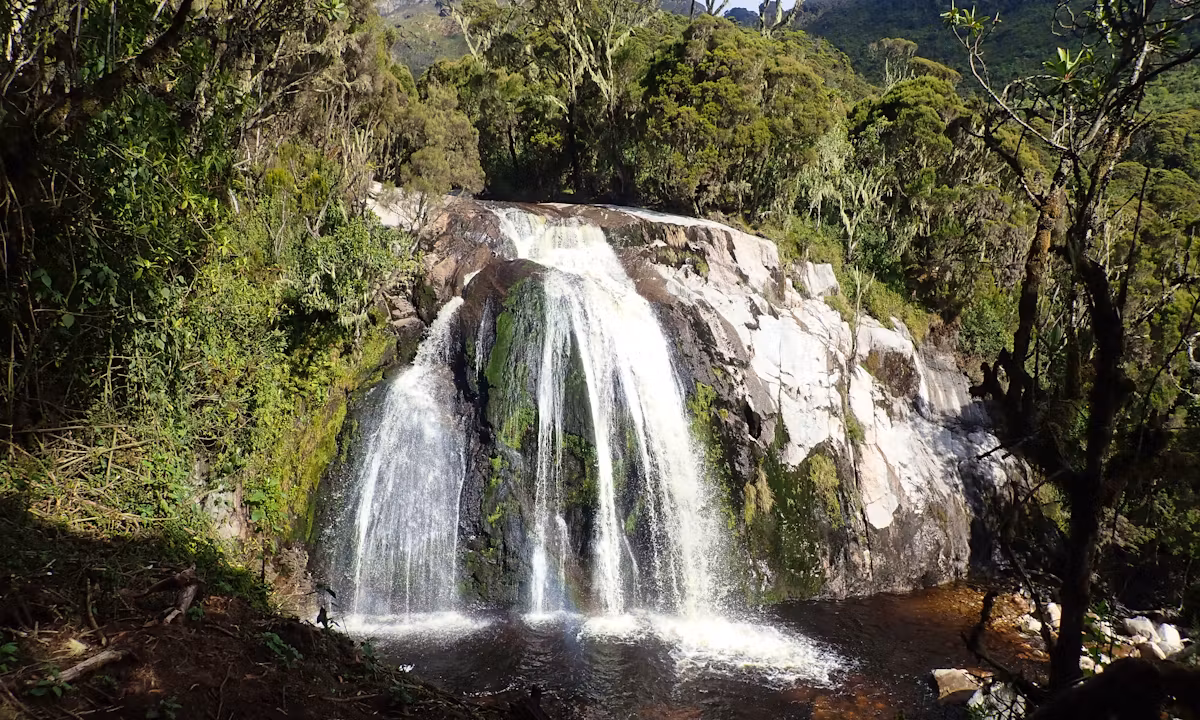
The trek’s focal point, the waterfall, is on Day 2. Starting in Sine Camp, the trail descends into the Samalira Valley, a narrow gorge with steep sides that conducts a massive amount of water. It then continues to climb over open heathland. Kabamba Falls, a 12-meter-tall waterfall where a torrent plunges over exposed rock, is within 90 minutes of your departure. This is the best spot to take pictures along the path since it is a dry ledge only a few meters from the bottom. The noise can be heard from half a kilometre away during the rainy season.
The route continues by ascending the Samalira Valley’s western wall, after which it descends precipitously to the river. As the trail winds its way around a crag of exposed rock, the buildup to Samalira Falls becomes increasingly dramatic, with a deafening rumble that reaches your ears before your eyes. Then it happens: a 40-meter double-tier waterfall plunging into a pool below, encircled by fog-shrouded hagenia trees and massive ferns. Among the many short treks in Uganda, this one leads to the most breathtaking waterfall. Although it is not as well-known as Sipi Falls, which is located in Uganda, Samalira Falls is far larger and attracts far fewer tourists.
Samalira Camp is located at an elevation of 2,900 meters, just above the falls. Unlike a lower-altitude camp, this one has an ambient soundtrack provided by the steady sound of falling water that carries through the night. A quality sleeping bag is a need at this altitude because temperatures drop to 8-12°C after dark. Check out our hiking trails overview for a rundown of all the different short Kilembe Trail options.
Waterfalls: Kabamba Falls + Samalira Falls (40m double-tier centrepiece) | Highlight: Samalira gorge, giant fern understorey
Sleep: Samalira Camp huts (2,900m) shared bunks, cooking shelter, toilet block
Day 3: Samalira Camp → Bugata Camp: Upper Waterfalls Exploration
Elevation: 2,900m → ~3,100m | Distance: ~8 km | Hiking Time: 5–6 hours
Exploring the lower afro-alpine and high montane zones is the focus of Day 3. At the border of the trail, the first ground orchids emerge as the trail ascends from Samalira, passing through a transition zone where Podocarpus and Hagenia give way to huge heathers (Erica arborea and Erica trimera). For a comprehensive botanical analysis of each biological layer you traverse, consult the vegetation zones guide.
The second ford of the main stream, which flows across exposed granite ledges, is within an hour of Samalira. A more subdued but attractive cascade, Upper Samalira Cascade is worth the cautious ascent to the edge of the water for the breathtaking views it offers. The water here is so pure because it is nourished by rain and glacier melt. As the trail continues beyond the cascade, it enters more open terrain, with the heather canopy gradually weakening to expose upper ridgelines through cloud gaps.
As a stark reminder of the immense alpine realm this walk merely skirts, the snow-capped ridges of Mount Stanley can be made out to the north on sunny mornings. In a broad braided portion near Bugata, the sources of the Mubuku River meet the trail. The last listed waterfall on the walk is Bugata Stream Falls, a small but powerful 15-meter cascade. After three days of hiking, you have seen six different types of water.
The trek’s highest sleeping spot is Bugata Camp, which is located at around 3,100 meters. Chilly, exposed to the wind, and breathtaking. On clear evenings, the Rwenzori peaks appear as a kaleidoscope of rock, ice, and waning equatorial light as they break through the clouds. We also offer a 4-day Mutinda Lookout Trek that starts at the same Kilembe Trailhead for those who are interested in expansive panoramic vistas at a similar pace.
Waterfalls: Upper Samalira Cascade + Bugata Stream Falls | Highlights: Giant heather forest, first Afro-alpine plants, Mount Stanley snowline views
Sleep: Bugata Camp huts (~3,100m), basic sleeping huts, cook shelter, toilet
Day 4: Bugata Camp → Kilembe Trailhead (Full Descent)
Elevation: ~3,100m → 1,580m | Distance: ~14 km | Hiking Time: 6–7 hours
After a 14-kilometer, knee-testing descent from Bugata to Kilembe, the Mubuku River acquires volume below and rewards patient with one last sequence of cascades. When you turn around and go back the way you came, you’ll see things from a whole different angle. Waterfalls that you were admiring from above will suddenly be visible from below, and forest bends that you couldn’t see when rising will now be apparent as you leisurely descend.
On your way east, you’ll pass Samalira Falls again, this time from an angle that allows you to see the gorge and Kabamba Stream below. Midway through the morning, the fog dissipates, revealing the Rift Valley in all its glory: sugar cane fields, marshes, and the valley floor that stretches out to the horizon. The trail will bring you back to Kilembe, where you can get a car and cold refreshments, after the Mwamba crossing returns for a final goodbye.
A certificate of completion and a debrief with your lead guide will round out your 4-day Rwenzori Waterfalls Hike. For those who are feeling inspired by the mountain, there are two options: either complete the Kilembe Trail or start with the 3-day Sine & Samalira Camp Trek.
Points of interest: Kilembe certificate, last aerial views of Samalira Falls, panoramas of the Rift Valley
End point: Kilembe Trailhead (1,580m) vehicle transfer to Kasese arranged by default
End of the 4-Day Rwenzori Waterfalls Hike via Kilembe Trail Route