5-Day Rwenzori Trek to Bujuku Hut via the Central Circuit
The 5-day Rwenzori trek to Bujuku Hut (3,977 m) is a deep, non-summit Central Circuit itinerary. It covers roughly 54 km round-trip, taking you through five distinct vegetation zones—including equatorial forest, bamboo, and the famous Afro-alpine Bigo Bogs—without technical glacier climbing.
Remain at 3,977 meters in the Bujuku Valley, encircled on three sides by the majestic massifs of Mount Stanley, Mount Speke, and Mount Baker—the fabled high-altitude triangle of the Rwenzori—without rope onto a single glacier. Hiking the Rwenzori to Bujuku over the course of five days is the deepest non-summit walk in the Mountains of the Moon in Uganda. Along the way, you’ll pass through all the mountain’s famous vistas and arrive at the point of highest drama.
Hike to Bujjuku Camp in the magical Rwenzori Mountains of Uganda for five days. Even without climbing to the peak, you can take in breathtaking views of Baker, Speke, and Stanley. Adventurers and ecotourists will adore this 5-day Rwenzori trek. Immerse yourself in the enigmatic Rwenzori Mountains, a Bujjuku Valley UNESCO World Heritage Site, on this 5-day Rwenzori Trek. If you want to see the mountains without having to climb Margherita, this 5-day Rwenzori trek to Bujjuku is for you.
Through verdant alpine bogs, bamboo groves and verdant montane woods, this walk follows the famous Central Circuit Trail. The Rwenzori Mountains are your destination as you make your way to Bujjuku Camp. Spectacular views of the Rwenzori triangle—Mounts Stanley, Speke, and Baker—are available from this spot in the Bujuku Valley. The track is accessible to the majority of walkers and provides an unusual blend of tranquillity, challenge, and stunning scenery. Take advantage of your chance to visit an underappreciated but no less interesting part of Africa’s ecosystem.
Why Do the 5-Day Rwenzori Trek to Bujuku?
Many hikers wonder, “Can I experience the real Rwenzori without summiting Margherita Peak?” when they read about the Rwenzori Mountains. Yes, I can confirm that with the 5-day Rwenzori trek to Bujuku. At an altitude of 3,977 meters, the Bujuku Valley is the most spectacular mountain amphitheatre in East Africa. Along the way, you’ll pass through every famous ecosystem: tropical rainforest, bamboo forest, cloud-heather zone, and the complete Afro-alpine moorland. No other non-summit itinerary goes deeper into the mountains than this one.
Day 3, when you reach Bujuku Hut in the upper Bujuku Valley and gaze up, is the moment that defines this walk. From this camp, you may see the Rwenzori triangle, which consists of three of Africa’s highest peaks (Mount Stanley, 5,109 m; Speke, 4,890 m; and Baker, 4,843 m) grouped in a horseshoe pattern of glaciated rock and clouds. Glaciers droop over every mountain range. Its size is intimidating in a way that words can’t express. Without a single tough climbing move, you can reach this vista, and the muddy meters leading up to it are well worth it.
Because of its moderate pace, the 5-day Rwenzori trek to Bujuku is suitable for a variety of hikers. Natural relaxation is built into this schedule, unlike the rushed 4-day Margherita Peak route. The first day’s walk to Nyabitaba Hut (2,652 m) is an easy 8 km, perfect for getting your blood pumping and your muscles used to the higher elevation. Gradual increases in altitude are introduced on Days 2 and 3. The long drop on Day 4 is rather gratifying. The fifth day is a leisurely stroll out. Rest assured, you will never be overextended. Every evening, you will have ample time to enjoy the scenery, enjoy a healthy meal, and get a good night’s sleep.
Additionally, this walk is among the most environmentally astounding short hikes in Africa, and we mean it when we say that. The encounters between 1,600m and 4,000m are the exact reason the Rwenzori Mountains are a UNESCO World Heritage Site: At 3,977 meters, you can see Lake Bujuku sparkling with glacial mist rolling across its surface, as well as Rwenzori turacos, black-and-white colobus monkeys, three-horned chameleons, gigantic lobelias as tall as a house, and ancient groundsel trees. This kind of wonder is delivered by very few hikes anywhere in the world if you care about wild regions, especially truly wild places.
A Detailed 5-Day Rwenzori Trek to Bujuku Camp Itinerary
Day 1: Nyakalengija → Nyabitaba Hut (1,600 m → 2,652 m) | ~8 km
Hiking time: 5–6 hours | Elevation gain: +1,052 m | Overnight: Nyabitaba Hut (2,652 m)
Briefing and Departure: The Rwenzori Begins Here
A little trailhead town at 1,600 m, about 13 kilometres northeast of Kasese, you will find the Uganda Wildlife Authority (UWA) registration office. From there, you will begin your 5-day Rwenzori journey to Bujuku. It would be highly recommended that you arrive the night before to your departure. The area is well-coordinated for guides, porters, and permission paperwork, and the lower forest is illuminated at its best in the morning, so it’s best to begin early.
There are a number of pre-trek formalities that should take no more than thirty to forty-five minutes to complete. These include verifying permits, allocating and weighing porter loads, and listening to a route briefing from your lead guide that covers the distances to be covered each day, expected timings, wildlife awareness, and the critical mountain safety rules that apply throughout the Rwenzori. Pay special attention to the parts on pace and altitude awareness; these will have the most impact on how enjoyable your mountain adventure is. This briefing is not an afterthought.
Through the Bakonzo Foothills
Starting in a tiny region of farmland owned by Bakonzo smallholders, the trail continues beyond. The indigenous mountain people of the Rwenzori foothills, known as the Bakonzo, have been farming these terraced slopes for many centuries, producing crops such as sweet potato, beans, and maize. As you go by, you’ll see houses, hear kids playing in the fields, and even see some elderly people waving from their front doors. As a reminder that the Rwenzori is not some pristine wilderness but rather a dynamic landscape that communities have shaped and inhabited for centuries, this is one of the most culturally grounding moments of the entire trek.
After around thirty to forty-five minutes, you’ll officially be in a tropical montane forest. There is a sudden change: the sky becomes overcast, the temperature lowers a few degrees, and the sounds of birdsong and rushing streams supersede those of the agricultural zone. The Mubuku River flows somewhere below the trail; its sound carries through the thick underbrush, making its sight difficult to perceive.
The Rainforest Ascent to Nyabitaba
Ascending for the following three to four hours will lead you through a magnificent highland forest in Uganda. The long white cloaks of the black-and-white colobus monkeys catch the filtered light as they wander across the canopy in groups of 6–15 individuals. Here, birdwatchers often see the Rwenzori turaco, a green-bodied bird with a flash of red wing, most often in the mornings. On Day 1, you might also see Rwenzori olive pigeons, Rwenzori batis, and L’Hoest’s monkeys in the middle of the canopy. These are all species that are unique to this area of Uganda and cannot be found anywhere else at this density.
A combination of root-bound dirt and occasional stone stairs makes up the trail’s steady ascent. When it’s dry, the trail is smooth, but when it’s raining, as it usually is in the Rwenzori, you’ll feel the mud under your feet within the first few kilometres. The free rubber boots are ideal for this kind of terrain. Starting on Day 1, your hiking poles prove their worth.
At 2,652 meters, Nyabitaba Hut is reached after 5 to 6 hours. Perched on a cleared hill, this cosy mountain cabin offers views of the Mubuku Valley to the south, cut through the forest canopy. This is the typical first night’s stay along the Central Circuit Trail, and it’s a really nice spot. As supper, your mountain cook will whip up a hearty three-course feast. Nighttime lows range from 10 to 14 degrees Celsius, which is chilly but not frigid. After a long day of climbing, sleep is a breeze.
Day 2: Nyabitaba Hut → John Matte Hut (2,652 m → 3,414 m) | ~12 km
Hiking time: 7–8 hours | Elevation gain: +762 m | Overnight: John Matte Hut (3,414 m)
The Kurt Schafer Bridge Crossing
Up and at ’em at 7:00, ready to hit the road by 7:30. The second day of the Rwenzori climb to Bujuku is longer and more varied than the first. On this day, you will cross the famous Kurt Schafer Bridge, one of the most atmospheric sites on the trail, and you will also pass through four unique bands of vegetation. Starting from Nyabitaba, the trail winds its way down through the forest for a short while before reaching the bridge.
Near the confluence of the Bujuku and Mubuku rivers is the Kurt Schafer Bridge, a precariously perched footbridge that spans a rugged ravine. Below, the rivers slam against rocks. On either side of the crossing, you can see mossy rock walls; tree ferns droop over it. This is the kind of spot that makes you want to stop what you’re doing and look out over the bridge. Once you cross over, the trail takes a left turn and grows steeper; the Rwenzori starts to exert its true might at this point.
Into the Bamboo Zone
There is a dramatic shift in the vegetation’s personality once you cross the bridge. As you make your way up, you’ll enter the mountain bamboo zone (Arundinaria alpina), a thicket of towering culms that gives the impression of a verdant tunnel. Mosses, orchids, and damp ferns cover the understory while light seeps in in varying rays. Wildlife often passes through the bamboo zone in the Rwenzori as it moves between different feeding zones; this transitional environment is partly forest and partly alpine. Here you can often see L’Hoest’s monkeys and, on occasion, you can catch a glimpse of the three-horned chameleon (Trioceros johnstoni), an endemic species of Rwanda, perched on branches just at eye level. The chances of seeing wildlife are high in this area, so take your time exploring.
Upper Forest and the Approach to John Matte
The forest gradually gives way to lower montane heath above the bamboo, where gnarled trees and heather covered with Usnea lichen lend the area an air of growing antiquity and otherworldliness. As you near John Matte Hut, the trail begins to climb steeply; by now, most hikers are experiencing the initial symptoms of altitude, such as shortness of breath on steep stretches and maybe a minor headache. With an altitude of 3,000 meters or above, this occurrence is completely typical.
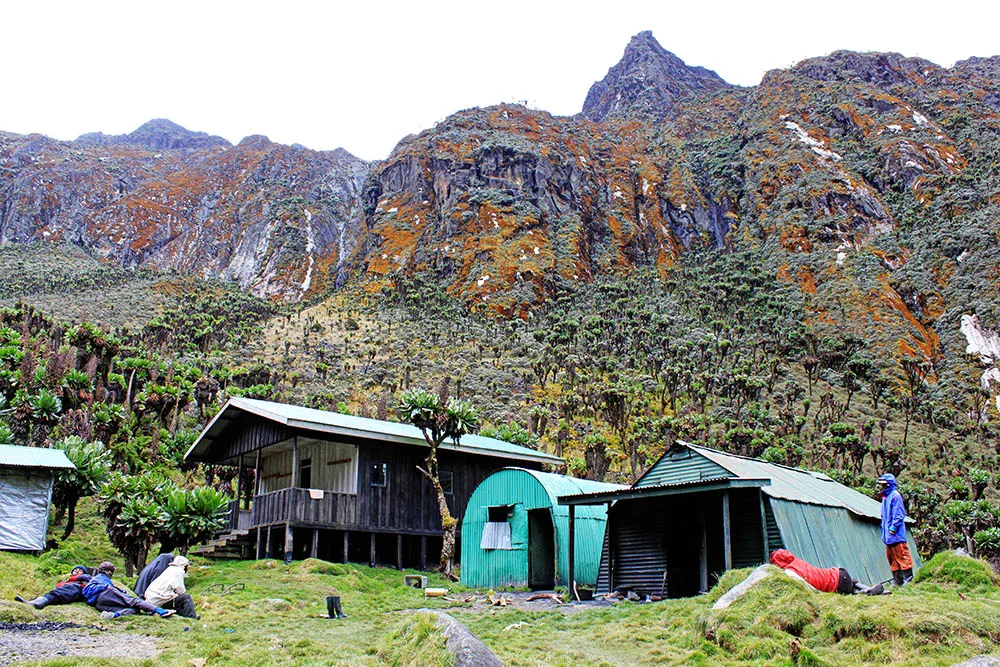
At an elevation of 3,414 meters, in a wide clearing at the boundary between the upper montane forest and the first real alpine zone, is where you’ll find John Matte Hut. With its separate kitchen and dining shelter, this hut, which is named after a famous Rwenzori mountain guide, can accommodate 16 people in tiers of bunk beds. As the sun sets over the valley, the lofty peaks in the distance offer a preview of what the day ahead may bring on clear evenings. Have supper at 7:00 and be in bed by 9:00. With lows of 5 to 8 degrees Celsius expected tonight, you’ll want to bring out your sleeping bag.
Day 3: John Matte Hut → Bujuku Hut (3,414 m → 3,977 m) | ~7 km
Hiking time: 4–6 hours | Elevation gain: +563 m | Overnight: Bujuku Hut (3,977 m)
The Bigo Bog: A Landscape from Another Planet
On the third day of the five-day Rwenzori trip to Bujuku, you will experience one of the most breathtaking mountain treks in all of Africa. The trek departs from John Matte Hut at 7:00 in the morning after breakfast and descends into the Lower Bigo Bog after a short descent into the valley level. You won’t find something like in Ethiopia, Tanzania, or Kenya. Located between 3,600 and 3,900 meters above sea level, the valley floor is an enormous peat bog that has formed over thousands of years. It is carpeted with cushion plants and is home to some of the most extraordinary plant species on the planet.
An iconic Rwenzori plant, the giant lobelia (Lobelia wollastonii) reaches a height of four to five meters and shimmers with retained moisture thanks to its silver-green rosettes. In the open, giant groundsels (Senecio adnivalis) create little trees with their thick, felted leaves and yellow blossoms. In between, you’ll find carpets of everlasting blooms, or Helichrysum stuhlmannii. To avoid sinking as you explore this ancient-looking landscape, there are long wooden boardwalks that carry you above the bog surface. Some of these boardwalks are 100 meters long or longer. To have a better grasp of what you’re seeing and why it’s unique to this area, educate yourself on the Rwenzori vegetation zones.
Upper Bigo Bog and Lake Bujuku
The trail continues past the Lower Bigo Bog and across a wooden bridge to reach the Upper Bigo Bog. Here, the dense Afro-alpine vegetation that was seen earlier persists even more so. Many days, the sky is low above the bog, and clouds blow in from the west over the Stanley massif, creating a hazy and dramatic setting that transports viewers to another time. There is complete quiet between the calls of the most prevalent birds, which include ravens and alpine chats.
From the Upper Bigo, the trail drops down to Lake Bujuku, a tarn formed by glaciers at an elevation of around 3,960 m. The lake’s black water reflects the peaks on all three sides. This is a true wilderness experience. As you sit on the shore of the lake, gaze westward. The rock faces of Mount Stanley, which stands at 5,109 meters, rise nearly vertically, with a dazzling band of ice visible above the mountain. Mount Speke, which stands at 4,890 meters, looms over the clouds to the north. Mount Baker, at 4,843 meters, completes the horseshoe shape to the south. Every summit route travels through this valley, but most hikers simply use it as a passageway; you are standing in its innermost chamber, the Rwenzori.
Arrival at Bujuku Hut
Resting atop the valley floor at an elevation of 3,977 meters, Bujuku Hut is about 10-15 minutes beyond the lake shore. On the third day of the five-day Bujuku trek, you will spend the night at the camp that is as spectacular a mountain camp as you will find in all of East Africa. With its separate kitchen and dining area, this hut can accommodate sixteen people in wooden bunk beds. In the afternoon, after the little hike, you can relax on the lakeshore, take in the scenery, and feel at one with the natural environment.
At Bujuku, it is possible for the nighttime temperature to dip below -2°C. As you dine, your guide will suggest adding layers for warmth. By 9:00 PM, the mountain is usually peaceful. Although the altitude (common over 3,800 m) may short disrupt sleep, one of the most memorable aspects of the climb for most trekkers is waking up in the small hours to see the mist lifted and the peaks lit by glaciers visible above the hut.
Day 4: Bujuku Hut → Nyabitaba Hut (3,977 m → 2,652 m) | ~19 km
Hiking time: 7–9 hours | Elevation loss: −1,325 m | Overnight: Nyabitaba Hut (2,652 m)
Descent Through the Alpine Moorland
On Day 4, you’ll begin the long descent. You’ll spend the entire day returning to the landscape you ascended on Days 2 and 3, but now you’ll see it in a whole new light, with your eyes trained to notice what it missed while it went up. Set out at 7:00 AM following brunch. Returning to the Upper Bigo Bog, the initial segment turns around the Lake Bujuku shoreline.
One of life’s most beautiful moments is descending the boardwalks while the peaks remain in view behind you. After being shaded by clouds in the morning on Day 3, the huge lobelias are now basking in the afternoon sun. Knowing their names makes the previously unfamiliar groundsels seem more familiar. You have slept here at 3,977 meters and have earned the privilege of calling it more than just a view.
Back Through John Matte and the Forest
Following that, the path descends sharply into the heather zone and, just below it, the bamboo forest. It takes three to four hours to descend from John Matte to Nyabitaba (2,652 m) on a well-worn track that becomes treacherous when it’s wet. The rooted, muddy parts that were so difficult on the climb are even more so when you’re tired and descending, so trekking poles are a must.
Depending on the amount of rain that fell overnight, the Bujuku and Mubuku rivers below the Kurt Schafer Bridge either roar or swell. The last ascent to Nyabitaba Hut begins in the late afternoon after you’ve made your way down through the forest. By 7:00 PM, dinner will be prepared by your mountain cook. On this, their final night on the mountain, many hikers unwind with their guides over tea and a meal, asking all the questions they had about the Bakonzo, the mountains, and the melting glaciers that they hadn’t thought to ask before. On many occasions, it becomes the trip’s most interesting discussion.
Day 5: Nyabitaba Hut → Nyakalengija (2,652 m → 1,600 m) | ~8 km
Hiking time: 3–4 hours | Elevation loss: −1,052m | End of trek
The Final Descent to the Trailhead
It takes three to four hours to descend to Nyakalengija after a leisurely breakfast. The trail winds its way down through the heart of the mountain woodland. On this last day, you may see the return of the Colobus monkeys, who seem to be saying goodbye, before making your way back to the trailhead through the Bakonzo countryside. While entering the higher agricultural zone, the Rwenzori peaks pop out of the forest for a short while on this last section of the trail. Stopping to look back is worthwhile.
You properly end your walk at the UWA trailhead office in Nyakalengija. Now is the time to stop thinking about that cold drink you’ve been craving since Bujuku, take pictures with your guides and porters, and tip them (for details, read our tipping recommendations for porters and guides). Get a ride to your Kasese lodgings or continue on to Fort Portal, Kampala, or wherever you’re going. As you go, the mountain follows.
End of the 5-Day Rwenzori Trek to Bujuku Camp Itinerary