4-Day Rwenzori Trek to Margherita Peak | Quick Rwenzori Hike
A 4-day Rwenzori trek to Margherita Peak (5,109m) is the fastest, most rigorous way to summit the Rwenzori Mountains. Designed for expert, high-altitude trekkers, it compresses a standard 7-8 day hike. It requires scaling over +3,500m of elevation and navigating technical glacier crossings in just 4 days.
For a duration of four days. 4,099 meters. Exactly one glacier. We will not budge. If you are an experienced, well-conditioned trekker who cannot afford a longer expedition but will not compromise on the summit, this is the fastest possible route to the top of Uganda. It is a condensed, high-intensity ascent of Margherita Peak via the Central Circuit Trail.
The 4-Day Rwenzori Trek to Margherita Peak offers a quick ascent via the Central Circuit. In only four days, you may reach the peak of Margherita on this Central Circuit trip via the Rwenzori Mountains. Those in search of a difficult summit ascent should consider this walk for advanced hikers.
Only highly experienced, physically fit, and well-acclimatized hikers should attempt this four-day Rwenzori trek to Margherita Peak (5,109 m).
This plan condenses the Central Circuit route into the shortest practicable timeframe without skipping key sections; normally, the Rwenzori walk to Margherita is performed in 6-7 days. Expect rigorous trekking hours, significant altitude climbs, glacier travel, and minimal recovery time. Inexperienced hikers or those who have never been to such high altitudes should not attempt the 4-Day Rwenzori Trek to Margherita Peak.
Why Choose the 4-Day Rwenzori Trek to Margherita Peak?
For the most part, hikers who visit the Rwenzori Mountains do the proper thing by allocating seven or eight days to complete the Central Circuit. However, there is a subset of hikers who find four days to be not only manageable, but ideal: experienced hikers at high altitudes who have been there before, have packed a lot into their schedules, and are physically able to hike 8 to 12 hours per day for three days straight at altitude.
There is little doubt that this 4-day Rwenzori climb to Margherita Peak is the safest and fastest way to reach Africa’s third-highest peak (5,109m). It streamlines the entire central circuit approach into the least amount of time while yet covering all the necessary camp progressions for reaching the summit. The Bigo Bog, the famous rainforest approach, the breathtaking alpine landscape above 4,000 meters, and the challenging glacier crossing to Mount Stanley’s peak will all be there.
Not the length of the journey, but the variety of landscapes covered in just four days is what really sets it apart. Amidst colobus monkeys and Bakonzo village villages, you start at 1,600 m in the equatorial rainforest. In the middle of strange Afro-alpine bogs dotted with lobelias as tall as a person, you’ll be crossing historic wooden boardwalks by Day 2. At dawn on summit morning, you will be roping up on an equatorial glacier while the pre-dawn sky reveals the curvature of Africa extending out in every direction. This is an experience you won’t find on any other four-day mountain tour in Africa.
Truthfully, this walk is far more taxing on your body than the seven-day Margherita Peak ascent. Just getting from Nyakalengija to John Matte Hut on Day 1 is an arduous ascent of 1,820 meters. In just eight hours, you will climb from 3,420m to 4,563m on Day 2. The day at the summit begins at 2:00 AM and lasts for ten to twelve hours. Our Margherita Peak 5-day hike or Central Circuit 6-day itinerary are more to your liking if you find any of that intimidating rather than exciting. However, if you are prepared, there are few African experiences that can compare to what lies ahead.
A Detailed 4-Day Rwenzori Trek to Margherita Peak
Day 1: Nyakalengija → John Matte Hut
Hiking time: 7–9 hours | Elevation gain: +1,820m | Overnight: John Matte Hut (3,420m)
Pre-Trek Briefing at Nyakalengija
The Uganda Wildlife Authority (UWA) trailhead station in Nyakalengija (1,600m), about 13km from Kasese town, is where your 4-day Rwenzori journey begins. Each trekker is usually assigned a porter to help carry their personal gear and the group’s stuff, which can weigh up to 15 kg. Before you set out, your guides will inspect all of your gear, verify your permits, and distribute the load. Setting aside at least 30–45 minutes should be sufficient time for this task. Make sure you don’t miss the briefing, where your guides will go over everything from summit glacier protocols to emergency evacuation methods to daily pace expectations.
A Climb Through the Forest: From the Village to Nyabitaba
The trail heads straight into a mosaic of mountain communities nestled in the slopes of the Rwenzori Mountains, where smallholder farmers and gardeners from the Bakonzo people have lived for generations. The mountains known as “Rwenzururu” (meaning “place from which rain clouds come”) hold a special spiritual significance for the Bakonzo people. The trail soon becomes fully immersed in a tropical montane forest, with the canopy drawing in closer to the trailhead. Birds abound in this region, including the crimson-winged Rwenzori turaco, the stream-dwelling Hartlaub’s duck, and scores of species that are exclusive to the forest. The top canopy is a common place to see black-and-white colobus monkeys.
Approximately three to four hours is required to climb to Nyabitaba Hut (2,652m). The first night’s camp is a nice break even on this shortened route, as it is on the longer Central Circuit itinerary. Here you will have lunch, a warm meal made by your mountain cook and the first of the delicious catered meals that your team will feed you with all day long on your journey.
The Upper Forest and the Kurt Schafer Bridge
Following lunch, the walk descends from Nyabitaba a little before crossing the renowned Kurt Schafer Bridge, a precariously positioned suspension footbridge that spans the Bujuku and Mubuku rivers’ meeting point. This is a very evocative scene on Day 1 due to the roar of the rivers below and the looming forest above. As soon as you cross the bridge, you’ll notice a dramatic difference in the landscape: the slope, rootiness, and muddiest parts of the terrain, with a transition to lower bamboo and mossy cloud forest for vegetation.
Day 2: John Matte Hut → Elena Hut (3,420 m → 4,563 m) | Approx. 12–13 km
Hiking time: 8–10 hours | Elevation gain: +1,143 m | Overnight: Elena Hut (4,563 m)
The Bigo Bog: A Prehistoric Adventure
Breakfast promptly at six o’clock in the morning. Among the 4-Day Rwenzori Trek to Margherita Peak, the second day offers some of the most breathtaking views of the Rwenzori Mountains. One of the most otherworldly mountaineering settings in Africa is the Bigo Bog, which can be reached by the trail that begins at John Matte. A thick mat of peat bog that has built up over millennia covers the valley floor here, which is at an elevation of 3,600-3,900 meters. You can walk above the marsh on long wooden boardwalks, some of which are hundreds of meters long. Huge lobelias, or Lobelia wollastonii, stand guard, their rosettes of glossy green leaves shimmering in the rain. They can reach a height of four to five meters. In every space between the boardwalks, you can find cushion plants, everlasting flowers, giant groundsels, and Helichrysum stuhlmannii. Nowhere else in Africa can you find an environment quite like this.
You can feel the air being much thinner here. Beyond 3,800 m, most hikers start to experience the affects of the altitude: a little shortness of breath on steeper portions, maybe a little headache in the afternoon. This is to be expected and may be handled by simply walking at the deliberate, rhythmic pace set by the guide. There will be no racing. Feeling more at ease here.
Bujuku Valley and the Approach to Mount Stanley
As the trail continues past the Upper Bigo Bog and into the Bujuku Valley, which was carved out by glaciers, the terrain abruptly shifts to become much more mountainous. On the right side of the skyline, you can see Mount Speke (4,890 m), and clouds that are moving quickly will often encircle its peak. Looking ahead, you can see the glacier as a stark white ribbon high on the mountain, and you can also make out the mountain’s flanks. It is just massive. Margherita experiences a fresh sense of intimacy and authenticity.
It takes about five hours of hiking from John Matte to reach Bujuku Hut, which is at 3,960 meters. This will serve as your overnight stop on the third day following the summit; you will pass it on the second day without making any stops. Here we will have a short break and warm refreshments before beginning the last push of the day.
The Final Climb to Elena Hut
On the second day of hiking, the most difficult part is the 600-meter climb from Bujuku Hut to Elena Hut, which is 4,563 meters. The landscape becomes more rugged, and when it’s raining, which is the case for the most of the Rwenzori, the stones become slippery from the moss and water. Walking sticks are a must-have in this area. As you ascend gradually, you’ll pass through dwindling flora, the final great groundsels, and finally, at the top, nothing but rock and ice.
Just below the Stanley Glacier, on a rocky platform, sits Elena Hut. Among the highest permanent camps in East Africa, it also happens to be the highest point of the Central Circuit Trail. You are higher than 98% of Uganda’s landmass at 4,563 m. Upon arrival, you will feel the cold; nighttime temperatures at Elena can fall to -2°C to -5°C. Be sure to have a hearty, hot dinner, drink plenty of water, and get into your sleeping bag by 8:00 PM at the latest. At 2:00 AM, there will be a summit call.
Day 3: Elena Hut → Margherita Peak → Bujuku Hut (4,563 m → 5,109 m → 3,960 m) | approx. 10–12 km
Total hiking time: 10–14 hours | Summit elevation gain: +546m from Elena | Total descent to Bujuku: −1,149m
Summit Night: 2:00 AM Departure
On the third day of the 4-Day Rwenzori Trek to Margherita Peak, there is no slowing down. At exactly one-half-hour before the crack of dawn, your guide will knock. You had on every layer you brought by two in the morning, including a thermal base layer, a fleece mid-layer, an insulated jacket, a waterproof shell, a harness, crampons, and a helmet that you snugged into place under the light of your headlight. After warming up with a mug of tea and some biscuits, you may brave the nighttime Rwenzori weather.
At 2:00 AM, the temperature is a profound 4,563 m. With wind chill, temperatures can drop to -8°C. Stunning equatorial stars fill the sky when clouds aren’t in the way. Perched nearly right above us is Orion. A glimmer of starlight reflects from the glacier far above you. As soon as your guide ties everyone in, the ascent effort is underway.
The Stanley Glacier Crossing
Climbing up the lower Stanley Glacier is the initial leg of the summit ascent. As you traverse the ice, your guide will trim steps as needed and expertly navigate crevasse zones and icefalls. The crampons are painful, the ice changes colour from blue to grey under your feet as your headlamp sweeps, and the exposure is obvious right away; all of this can be a bit overwhelming for someone who has never walked on a glacier before.
Scientists currently believe the Margherita Glacier’s collapse is irreversible; it is one of the few tropical glaciers in Africa and a genuine equatorial glacier. In the last hundred years, the Rwenzori glaciers have shrunk by more than 80% of their original size. It is becoming more and more rare to witness something as unique as standing on this ice. As compared to earlier African summits, this one has more significance due to the scientific urgency of the present.
The Margherita Glacier and Fixed Rope Sections
The trail becomes much more rugged after passing the Stanley Glacier. Obstacles covered in ice necessitate deft footwork and, on more difficult portions, the use of fixed ropes for support. On the more exposed parts, your guides have set anchor points. Secure your safety line to each of these and proceed step-by-step. Technically, this is the most difficult part of the whole route.
The last leg of the ascent takes place on the Margherita Glacier. There are spots when the gradient becomes 45–55 degrees. Two or three especially exposed rock steps can be aided by fixed ladders. Even the most seasoned hikers will be pushed to their limits by the combination of high altitude, physical exertion, frigid temperatures, and the sheer magnitude of the exposure, which makes it seem like the bottomless pit if you look down.
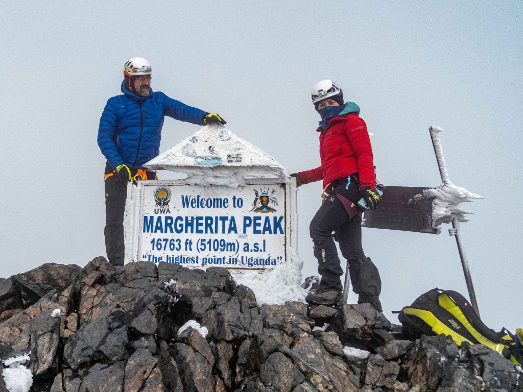
The Summit: Margherita Peak (5,109m)
You should expect to reach the summit ridge around 6:00 to 8:00 in the morning, depending on your group’s pace and the weather, as the sun starts to rise in the east. The actual summit of Mount Stanley and the Rwenzori Mountains, Margherita Peak, is commemorated by a modest metal plaque that dates back to 1906, when the Duke of Abruzzi made the first ascent. In the east, Uganda stretches out under you, while in the west, the Democratic Republic of the Congo fades into the cloud. On sunny days, you may make out the southernmost tip of Lake Edward.
No one should stay on top for too long. Because of the wind, cold, and possibility of weather changes, you usually only have 20 to 40 minutes at the peak, which is more than enough time to take photographs, ponder, and feel personal pride in having climbed Africa’s third-highest peak. Then the drop starts right away.
Descent to Bujuku Hut
As you descend from Margherita to Elena Hut, you’ll encounter the tricky sections of the morning, which were probably more taxing for your fatigued legs. Down-climbing on slippery rock requires constant emphasis on your footwork. Midway through the morning is when most groups reach Elena Hut, where they have a hot lunch, change clothes, and then resume their journey.
After Elena, you’ll have to descend for two or three hours to reach Bujuku Hut (3,960m). After the glacier, the Bujuku Valley is almost warm, and the return of colour from the big groundsels and heather is much appreciated. Bujuku Hut is the perfect place to celebrate your hard work and the peak behind you with a celebratory dinner. Before tomorrow’s long final descent, get plenty of sleep.
Day 4: Bujuku hut → Nyakalengija (3,960 m → 1,600 m) | approx. 20 km
Hiking time: 8–9 hours | Elevation loss: −2,360m
The Long Descent to the Trailhead
Day 4 is physically taxing in a different way than the ascending days; it contains a long, gruelling descent. The impact is absorbed by your knees, ankles, and toes as gravity takes care of the change in altitude. Proceed with a hearty breakfast at 6:30 in the morning. A midmorning break is provided by John Matte Hut before the route retraces the Central Circuit through the Bujuku Valley and across the Bigo Bog boardwalks, which seem weird on the way back when your body is still carrying the memories of the summit.
The trail descends sharply from John Matté, returning to the upper montane forest zone. As you descend, the vegetation undergoes a quick transformation, transitioning from heather to enormous lobelia, mossy cloud forest, and finally, thick tropical rainforest. At lower elevations, birds that were previously inaccessible, such as sunbirds flitting across clearings and turacos crowing in the trees, make an appearance. With time, the temperature rises again.
Nyabitaba and the Final Forest Section
For a delicious lunch, make your way to Nyabitaba Hut (2,652m). Depending on the amount of rain that fell overnight, the river below becomes either louder or quieter as you make your final crossing of the Kurt Schafer Bridge. The last three to four hours descend to Nyakalengija (1,600 m) across farmland and Bakonzo villages.
The feeling of relief and loss is palpable the second you disembark from the mountain at the trailhead office. Over the course of four days, you’ve become rather close with your guides and porters, whose expert navigation of the Rwenzori mountain trails made it feasible for you to reach the peak. Now is the opportunity to take group photos, tip your Rwenzori guide or porter (see to our tipping guide for details), and finally have that refreshing drink that has been niggling at you ever since Elena Hut. Return to your Kasese hotel or continue your journey as planned.
End of the 4-Day Rwenzori Trek to Margherita Peak Itinerary