5-Day Mount Speke Trek | Hiking Vittorio Emanuele Peak
The 5-Day Mount Speke trek is a challenging, highly rewarding expedition in Uganda’s Rwenzori Mountains. Reaching an elevation of 4,890 m (16,043 ft), it is the second-highest peak in the range. The climb requires solid physical fitness and usually begins at the Nyakalengija base camp near Kasese, traversing through dense bamboo zones and giant lobelias.
Mount Speke, one of the most majestic and solitary mountains in Uganda located in the Rwenzori Mountains, is the endpoint of the extraordinary 5-Day Mount Speke Trek. Unparalleled alpine trekking in Africa’s UNESCO World Heritage Site “Mountains of the Moon” promises to be an unforgettable adventure.
New experiences and challenges await you on a daily basis. The landscape consists of bamboo forests, thick jungle pathways, and marshy valleys teeming with gigantic lobelias. Peering out over Lake Bujuku, Mount Stanley, and the Rwenzori Range, the 4,890 m Mount Speke provides breathtaking sights. A fascinating walk is best ended in that fashion. This unusual route should only be attempted by the most daring and experienced hikers. Anticipate being amazed and pushed to your limits.
When you go to certain mountains, your perception of what a mountain is like will change irrevocably. Among the second group is Mount Speke, the second-highest peak in the Rwenzori Mountains and the fourth-highest summit in Africa. Its Vittorio Emanuele Peak, which stands at 4,890 m, dominates Lake Bujuku in a surreal and isolated environment that sees just a small number of trekking groups year. For that reason alone, this climb ranks among the most sought-after and obscured alpine goals in all of tropical Africa.
During the course of the 5-Day Mount Speke Trek, you will pass through each of the Rwenzori’s ecological zones: the moss-covered heather zone, the fantastic Afroalpine realm of gigantic groundsels and senecio trees, the bamboo corridors, the infamous Bigo Bog with its gigantic lobelias standing like prehistoric sentinels, and lastly the technical upper mountain, where a harness, ice axes and ropes distinguish this peak from any ordinary high-altitude walk. Just five days. All night long. A peak that will test your mettle to the limit.
Why the 5-Day Mount Speke Trek?
Compared to Mount Kenya and Kilimanjaro, the Rwenzori Mountains see a fraction of the number of tourists each year. Among those who do venture afoot, most follow the 7-Day Central Circuit in an effort to reach Margherita Peak. Mount Speke is only climbed by a small fraction of the Rwenzori visitors annually. You are embarking on an expedition that is truly unique: climbing a real high-altitude peak that the majority of East African hikers have never heard of, on a path that virtually isolates you from the mountain.
Completeness in terms of ecology is the second difference. In 2.5 days of climbing, the Central Circuit Trail approach covers all five of the Rwenzori’s main plant zones, a biological adventure that fits the space of a mountain valley like a continental altitude traverse. This level of ecological transition is not offered by any other Ugandan trekking program. You will have traversed the lower afro-alpine zone, a Bigo Bog with its bizarre huge lobelia fields, tree heather, bamboo, and an African equatorial forest before arriving at Bujuku Camp at 3,962 meters.
The summit itself is the third distinguishing feature. You won’t be able to stroll up Vittorio Emanuele Peak. The last ascent from Bujuku via Groundsel Gully requires a harness, fixed ropes, and the kind of exposure that immerses one’s attention in the work at hand. One of the best vistas in equatorial Africa is the view from the peak of Mount Stanley, which includes the Stanley Glacier to the west, Lake Bujuku far below to the east, and the foothills of the DRC border stretching out to the horizon. A picture just can’t capture its beauty. For all the technical work, there is the payoff.
Read our Central Circuit Trail comparison and route difficulty guide before you decide between this trek and the 7-Day Margherita Peak climb. Although both treks follow the same general outline, the 7-day Speke allows for more time to acclimatise and reaches the highest peak, while the 5-day trip is shorter and more technically focused. Speke is often attempted first by serious trekkers, who later return for Margherita.
A Detailed 5-Day Mount Speke Trek Itinerary
Day 1: Nyakalengija Trailhead (1,646 m) to Nyabitaba Hut (2,651 m)
Distance: ~10 km | Elevation Gain: ~1,005 m | Hiking Time: 5–6 hours | Terrain: Afro-Montane forest, river valley, steep ridge
You will start your 5-day Mount Speke trek at the ranger station and trailhead in Nyakalengija hamlet, about 22 km from Kasese, which is run by the Uganda Wildlife Authority. The route, safety procedures, emergency plans, and technical equipment that will be needed later in the hike are reviewed in a morning briefing with your guide team. Here, we verify and validate park entrance permits. We will depart no later than 9:00 AM. Forests cover the entire first day.
After quickly dropping into the Mubuku River Valley, the trail continues on through a network of footbridges and into the thick Afro-montane forest that defines the lower Central Circuit. This 4-kilometer warm-up walk will help your legs and lungs get used to the terrain before the day’s climb. In this remarkable forest, you may hear the chirping of Rwenzori turacos, African green broadbills, and gorgeous francolins below, as well as see towering Symphonia and Podocarpus trees covered in thick green moss and lichen on every branch and trunk.
The trail begins its long ascent up the Nyabitaba ridge after crossing the Mubuku River on a wooden bridge—a classic Rwenzori moment—with the river gushing fast and cold over dark volcanic rocks below. The 600+ metre climb into the thickening moss forest, which is becoming more and more damp and silent, is the day’s most strenuous physical activity. You have to pay close attention to your feet the whole time because the track surface is mostly tree roots.
In this part of the forest, you can see blue monkeys hanging out in the trees, and if you look closely, you can see the endemic three-horned Rwenzori chameleon (Trioceros johnstoni) creeping slowly along the trailside. Native mountain dwellers have known and used the lower forest on the Central Circuit for generations, and your guide will point out medicinal herbs used by the Bakonzo group.
On bright afternoons, you may see the distant silhouette of Mount Stanley to the north when you reach Nyabitaba Hut (2,651 m) as the ridge levels out and the first views open. Sleeping in bunks with blankets provided and meals cooked by your guide team—this is the hut, a wooden mountain camp. One of the better places to take pictures on the lower circuit is at the Porter’s Rest Bridge, which is just a short walk down from camp. It offers a breathtaking view of the Mubuku Valley. The actual ascent starts with supper, followed by a briefing for Day 2 and an early night tomorrow.
Day 2: Nyabitaba Hut (2,651 m) to John Matte Hut (3,380 m)
Distance: ~11 km | Elevation Gain: ~729 m | Hiking Time: 6–7 hours | Terrain: Bamboo zone, heather zone, ridge traverse, river crossing
On Day 2, the Rwenzori’s vegetative character starts to change from forest to something completely alien, and it is also the longest day of the journey in terms of distance, at 11 km. The trail descends to cross the Bujuku River and starts the steep ascent toward John Matte Hut after breakfast at Nyabitaba. It then continues north along the ridge.
At about 2,700 meters, you’ll enter the bamboo zone, where towering mountain bamboo (Arundinaria alpina) creates atmospherically muted tunnels that close overhead. Muddy feet and a tight route necessitate single-file pace for the most of the stretch as you make your way through the bamboo forest. In this area, you can hear the characteristic calls of Rwenzori turacos and see the bright scarlet flash of their flight feathers, which prove that you have spotted one.
Starting as small areas of giant tree heather (Erica arborea) scattered throughout the forest, the heather zone gradually expands above the bamboo. Eventually, the forest disappears and you’re faced with a world of tall heather trunks covered in Sphagnum moss, old-man’s-beard lichen, and the rare sight of Carduus afromontanus thistle. On sunny days, the open ridge parts provide panoramic views of Margherita Peak and Mount Stanley, the first proper views of the surrounding giants.
One of the most spectacularly sited camps on the whole Central Circuit, John Matte Hut (3,380 m) is located in the heather zone on a wide open plateau. From its vantage point in the valley, the hut offers a breathtaking view of the sunset on clear evenings as the sun sets over the faraway Ugandan lowlands. Now that you’re at 3,380 m, the altitude starts to matter: on your first night here, you might feel a little queasy or have less appetite than usual. It is common for this to happen. Eat plenty of healthy food, drink plenty of water, and don’t rush through it. Your health will be closely monitored by your guide.
Day 3: John Matte Hut (3,380 m) to Bujuku Hut (3,962 m) via Bigo Bog
Distance: ~5.5 km | Elevation Gain: ~582 m | Hiking Time: 4–5 hours | Terrain: Bigo Bog, giant lobelia fields, alpine basin
Even though it’s the shortest of the five days of hiking, Day 3 offers some of the most breathtaking scenery. Starting at John Matte, the trail drops down to the valley floor for a little while before heading across the Bujuku River into the Lower Bigo Bog, the most renowned and otherworldly feature of the Rwenzori.
Spanning the valley floor at an elevation of 3,400-3,500 meters, the Bigo Bog is a wetland located at a high altitude. Careful footwork is required to cross the bog, since the path is constructed on logs and board sections in some areas but in many others one must simply across the bog through muck and standing water up to one’s knees or ankles deep. High waterproof gaiters or gumboots are a must. The sandal-wearing porters you hired will make the crossing appear easy because of their incredible speed and agility. This is not the case.
Giant lobelias, or Lobelia wollastonii, are the dominant plant species in the bog. These old plants seem completely out of place in a temperate alpine setting, with their bizarre, rosettes of grey-green leaves supporting flower spikes that are 2-3 meters tall. These plants have evolved into something completely unique at high altitudes, moulded by four thousand years of equatorial mountain circumstances. They are not just tall plants that happen to exist at high altitudes; they are truly altitude plants. As you ascend, you’ll see enormous groundsels (Senecio adnivalis), another famous alpine plant of the Rwenzori, growing in thick colonies across the upper valley on succulent rosette stems that rise on exposed trunks.
The trail continues its ascent after the bog crossing until it reaches Lake Bujuku, a glacially formed basin with Mount Baker to the south and Mount Stanley’s towering slopes to the west. The lake is shallow and glassy and is located at about 3,900 meters. On sunny days, the tranquil lake surface reflects the surrounding peaks, and the valley walls covered in enormous senecios make this a popular photo op in the Rwenzori Mountains. Feel free to linger here.
Located on a grassy slope, Bujuku Hut (3,962 m) overlooks the lake. Nighttime low temperatures are accompanied by substantially thinner air at this altitude. Lows of -5 °C or lower are not uncommon at Bujuku. While you rest up for tomorrow’s summit attempt, your guiding crew whips up a hearty dinner. Here is where the summit briefing takes place, during which the guide and trekker review the technical gear, Groundsel Gully route, anticipated summit time, and turnaround protocol. The summit day alarm is usually set between 3:00-4:00 AM, thus arriving late at night is not an option.
Day 4: Bujuku Hut (3,962 m) → Summit Vittorio Emanuele Peak, Mount Speke (4,890 m) → Return to John Matte Hut (3,380 m)
Distance: ~10–12 km round trip to summit + 5.5 km descent to John Matte | Total hiking time: 9–11 hours | Terrain: Technical alpine Groundsel Gully, fixed ropes, summit ridge
Between three and four in the morning, you can hear the little alarm go off. In the Bujuku hut, a hearty breakfast of eggs, porridge, and tea is brought out by torchlight. Finally, your guide will make sure that your harness, ice axe handle, headlamp batteries, and emergency whistle are all in working order. As the sun sets over the lake, you set out from Bujuku in the dark, guided only by your headlamps. Just before sunrise, the air at 3,962 meters is icy. It is on this day that the expedition is officially named.
From Bujuku, the summit approach takes a difficult ascent through the Afroalpine zone up the south-facing slope of Mount Speke. As you make quick progress up the trail, you’ll see giant groundsels (Senecio adnivalis) silhouetted against the early morning sky. The ground beneath your feet changes from mossy grass to stony scree and, in certain seasons, to an icy slope that requires crampons or cautious axe usage. When your guide pushes forward, it’s time to follow suit; don’t cut corners.
The approach delves into Groundsel Gully, a narrow and steep couloir so called because of the enormous groundsel plants that line its base. At this point, the fixed ropes start. With the help of your guide, you will be able to follow along with the fundamental steps: For the first few rope lengths, keep your gaze fixed upwards while you find your rhythm, using three points of contact and the ice axe for balance. Even though the gully is out in the open, the rock is really substantial. Proceed with precision and have faith in the system.
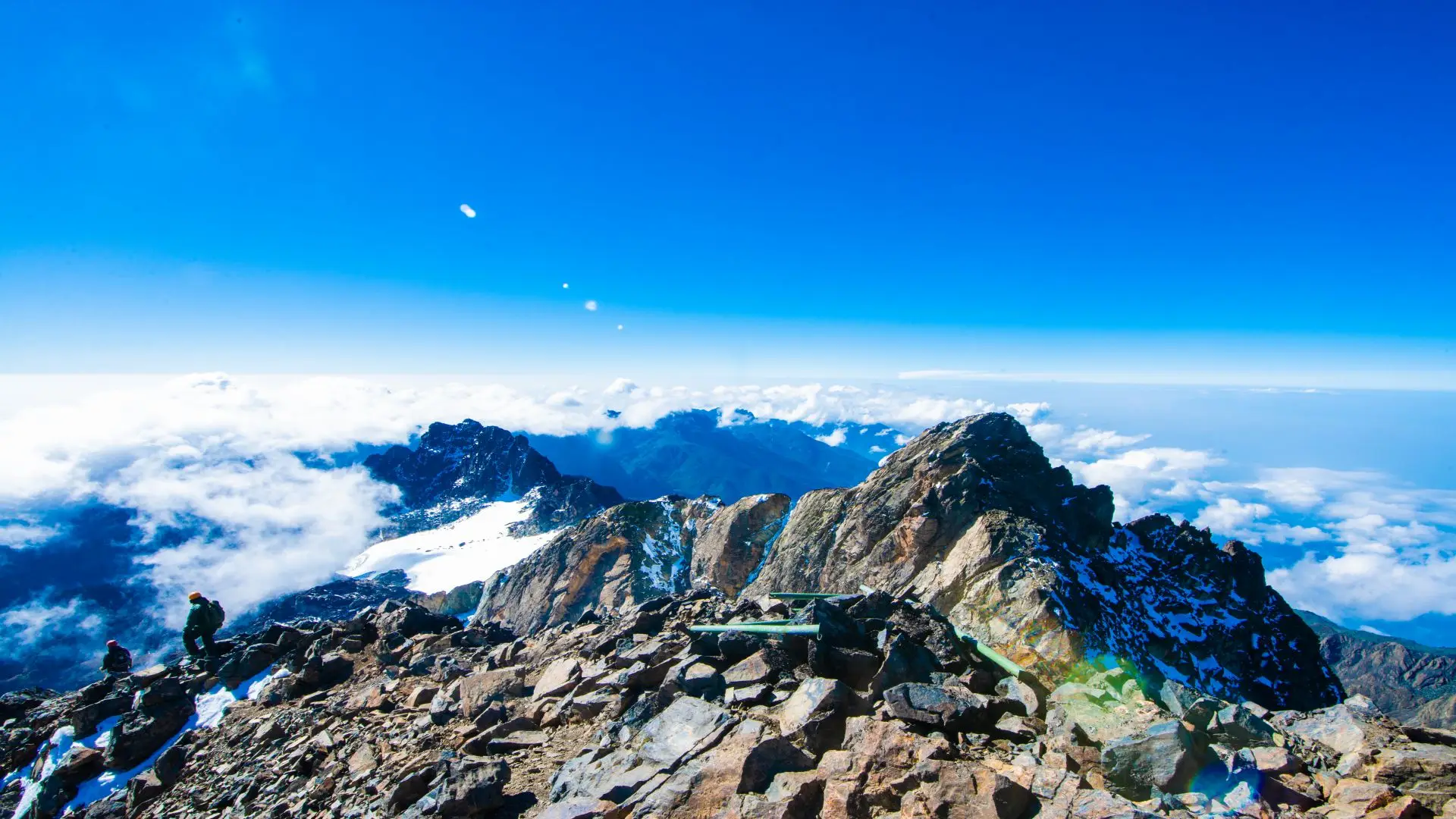
The upper ridge of Vittorio Emanuele Peak, seen above the gully exit, becomes visible as the sky lightens to the east, behind you. The last ascent to the summit ridge is challenging, but doable with the aid of a rope. Next up is the peak. Under the bright light of a tropical dawn, 4,890 m Vittorio Emanuele Peak stands. The western sky is dominated by Mount Stanley and its residual glacier, while to the east, 900 meters lower, lies Lake Bujuku, a black mirror. The DRC border highlands gradually disappear as one moves north, while the expansive Ugandan plains reach into the horizon to the south. For a few minutes, the majority of hikers stand here quietly. A few of them even cry. Everyone will always remember it.
Photos at the peak, some downtime, and a warming beverage from your guide’s flask. The controlled descent continued by reversing the usage of fixed ropes to cross the gully and make its way back to Bujuku over the afro-alpine slopes. The descent to John Matte Hut (3,380 m) begins after you gather your sleeping kit and congratulate the porter crew. During the three to four hours of descent, you will lose about five kilometres of altitude, which will provide you warmth, oxygen, and a deep feeling of accomplishment. The trek’s finest meal is dinner at John Matte.
Day 5: John Matte Hut (3,380 m) → Nyabitaba Hut (2,651 m) → Nyakalengija (1,646 m)
Distance: ~15 km | Elevation Loss: ~1,734 m | Hiking Time: 6–7 hours | Terrain: Heather zone descent, bamboo, forest, river crossing
The last day consists of a 15-kilometer descent from John Matte to Nyakalengija, a loss of 1,734 meters of elevation spread out over six or seven hours. Day 5 is a marked change from the exhilarating but emotionally taxing summit day; it is reflective and serene as the mountain gently releases you back into the valleys.
The trail heads back down through the heather zone in the opposite direction after breakfast, leaving John Matte. Even though it demands more concentration on your part, descending across open heather is quicker than climbing. The path can be quite treacherous after a night of rain or dampness, and there are several steep sections. This initial descending stretch is where trekking poles really shine.
Now that we’re back in the bamboo zone, the weather is hot and muggy, and the sound of birdsong has intensified, which is wonderful. On Day 5, the bamboo corridor is the most likely to yield wildlife encounters compared to any other point on the walk, however the climbing trekker makes more rapid progress through the bamboo than the descending trekker. The Rwenzori turaco, malachite sunbird, and Rwenzori double-collared sunbird are most active during the morning feeding hours in the heather-bamboo transition zone. Be careful as you descend.
We had a short break and packed lunch at Nyabitaba Hut before making the last descent to Nyakalengija. There are blue monkeys in the treetops, the Mubuku River’s roar gets louder as you descend, and the scent of the forest floor returns after four days up high in the lower forest area, all of which bring back memories of the humid, warm air of the tropical jungle. A closing ceremony of sorts is held on Day 5, which is the same day as the Mubuku River bridge crossing, which was so important on Day 1.
At the Nyakalengija ranger station, the climb comes to an end. Here, participants receive completion certificates, UWA documents the summit ascent, and the guide crew is officially thanked. Here you can find the Tipping section, which explains how tips are dispersed. A hot shower and a much-needed dinner are waiting for you when you return to Kasese, which will take about 30 to 40 minutes by transfer. After visiting Kasese, the next stop is usually Fort Portal, Kampala, or Bwindi for gorilla trekking.
End of the 5-Day Mount Speke Trek Itinerary