6-Day Rwenzori Trek to Weismann’s Peak via Kilembe Trail
This rewarding 6-Day Rwenzori Trek to Weismann’s Peak (4,620m) in the Rwenzori Mountains offers an unforgettable, non-technical trek through towering Afro-alpine valleys, lush bamboo zones, and vibrant giant lobelia meadows.
This 6-Day Rwenzori Trek to Weismann’s Peak (4,620m) combines raw verticality, ecological drama, and genuine remoteness, making it one of the rarest hikes in East Africa. Starting at the base of the Nyamwamba Valley in a cathedral forest, you will ascend through all of the Rwenzori’s ecological zones. At 4,450 meters, you will cross Bamwanjara Pass with three of Africa’s highest peaks encircling you. At the top of the pass, you will stand above glacial valleys on a precipitous blade of rock. From there, you will descend into a different valley and return to civilisation. As one of Uganda’s most diverse alpine routes, it is essentially a point-to-point mountain crossing.
Come along on a guided 6-Day Rwenzori Trek to Weismann’s Peak via Kilembe Trail. The walk winds through woods, through alpine bogs, across high mountains, past lakes and then plunges dramatically into the Nyamwamba Valley.
6-Day Rwenzori Trek to Weismann’s Peak via Kilembe Trail (4,620 m) and follows the picturesque but strenuous Kilembe Trail, providing one of the most varied and intense high-altitude trekking experiences in East Africa. Before plunging precipitously into the secluded Nyamwamba Valley, the route takes in every major natural zone of the Rwenzoris, from bamboo jungles and dense Afro-montane rainforests to gigantic heather forests, alpine boglands, glacial basins, and exposed high mountains.
Approximately 30–40 minutes from Kasese town and 8–9 hours by automobile from Kampala is where this excursion begins at Trekkers Hostel Kilembe, which is also called Rwenzori Backpackers Hostel in Kyanjuki.
The Kilembe Trail is steep and unforgiving, in contrast to the Central Circuit’s gentle lap around Mount Stanley. In the midst of the Rwenzori Mountains, it continues down the Nyamwamba Valley. The environment is marked by sudden shifts in elevation, erratic weather, and an untamed quality that contemporary hikers never encounter.
The Rwenzori Mountains are home to some of the most breathtaking peaks, including Weismann’s Peak, which is a component of the Mount Speke massif. With McConnell’s Prong and the sharp peaks of Mount Baker and Stanley as its backdrop, it rises like a blade above alpine bogs and glacial valleys.
Why Choose the 6-Day Rwenzori Trek to Weismann’s Peak?
With an elevation of 4,620 meters, Weismann’s Peak is one of six named summits in the Rwenzori Mountains. Among the accessible high peaks in the Rwenzori, it is one of the least-climbed peaks. The reason for that is not that it is of low quality. Reason being, compared to the Central Circuit, the Kilembe Trail leading to it is more rugged, steeper, and less travelled. If you’re looking for a beaten path across the mountains with plenty of markers, you won’t find them among these trekkers. They achieve what they wanted—something wilder.
In terms of its route character, the Kilembe Trail is radically distinct from the rest of the central circle. It starts in the Rwenzori Backpackers Hostel in Kilembe, a pre-colonial copper mining town at the foot of the Nyamwamba Valley, and takes a nearly vertical ascent into the mountains. Uncompromising in its approach, the route climbs 1,146 meters on the first day through the Rwenzori’s deepest Afro-montane forest, past waterfalls, enormous mossy trees, and primate habitat, before arriving at Sine Camp at 2,596 meters. One of the most well-appointed high camps in the range, Bugata Camp (4,100 m) offers views across Lake Kopello and straight up to Weismann’s unique summit blade; you’ll be camping there by Day 3.
The format of this 6-day schedule as a genuine traverse is what makes it so special. After entering the Kilembe Trail through the Nyamwamba Valley, you will cross the magnificent Bamwanjara Pass (4,450 m) on Day 4, reach the summit of Weismann’s Peak on Day 5, and then, on Day 6, descend down through the secluded upper Nyamwamba Valley, a very different descent from the other way around. One of the most spectacular last days of Rwenzori trekking is the one through the Nyamwamba Valley gorge, which is characterised by moss-covered rock sides, increasing primate activity as one descends from higher altitudes, and gushing waterfalls. You don’t have to go back up the mountain in any way. A real mountain traverse, this is not.
A breathtaking view of the middle Rwenzori massifs, including Mount Stanley (5,109 m), Mount Baker (4,843 m), and the entire high ridge, can be enjoyed from Hunwick’s Camp (3,974 m) the night before the summit. No one seems to be on this mountain. Since the Central Circuit sees far more hikers than the Kilembe Trail, you may find yourself on summit morning with no one else around, disturbed only by the sound of wind and the rare raven. This is the best path in the Rwenzori Mountains for seasoned hikers who choose quiet and natural beauty over crowds.
A Detailed 6-Day Rwenzori Trek to Weismann’s Peak Itinerary
Day 1: Kilembe Trailhead → Sine Camp (1,450 m → 2,596 m) | ~9.5 km
Hiking time: 6–7 hours | Elevation gain: +1,146m | Overnight: Sine Camp (2,596m)
Kilembe: The Kilembe Trail Begins
Kyanjuki is a little community at the base of the Nyamwamba Valley, about 35 km from Kasese town (about 40 minutes by car). From here, your 6-day Rwenzori Weismann’s Peak Trek starts at the Rwenzori Backpackers Hostel, also called Trekkers Hostel Kilembe. To ensure you reach Sine Camp on time on Day 1, you must depart early in the morning. At Kilembe, you will complete guide introductions, porter load allocation, permission verification, and equipment checks. It is highly advised that you arrive the evening before.
In the pre-trek briefing, we go over the Kilembe Trail’s layout, how to manage your altitude, what to do in an emergency, and the main distinction between this route and the Central Circuit. Before setting out on the Kilembe Trail, hikers should know that it is a less populated path with fewer amenities, more exposed landscape above treeline, and more unpredictable weather. Everything you need to know will be explained in your handbook. Stay focused.
The Nyamwamba Valley Forest Ascent
Among the most biologically rich areas in the Rwenzori Mountains, the trail heads straight into the lower Nyamwamba Valley. The Afro-montane rainforest that lies beneath the Kilembe valley floor has been protected since 1994 as part of the Rwenzori Mountains National Park, which is a UNESCO World Heritage site. A carpet of ferns covers the ground, and the cries of woodland birds fill the air before daybreak. The trees here are old hardwoods covered in epiphytic moss and lichen.
The lower Nyamwamba Valley is a great place to see primates. As a family, we sometimes see the culturally significant L’Hoest’s monkey (Allochrocebus lhoesti), which is a species that is particularly vulnerable owing to habitat loss; blue monkeys (Cercopithecus mitis) forage in the mid-canopy; and black-and-white colobus monkeys (Colobus guereza) move through the canopy in groups. Despite the rarity of sightings on this route, distant chimpanzee calls occasionally reverberate across the valley from nearby forest patches.
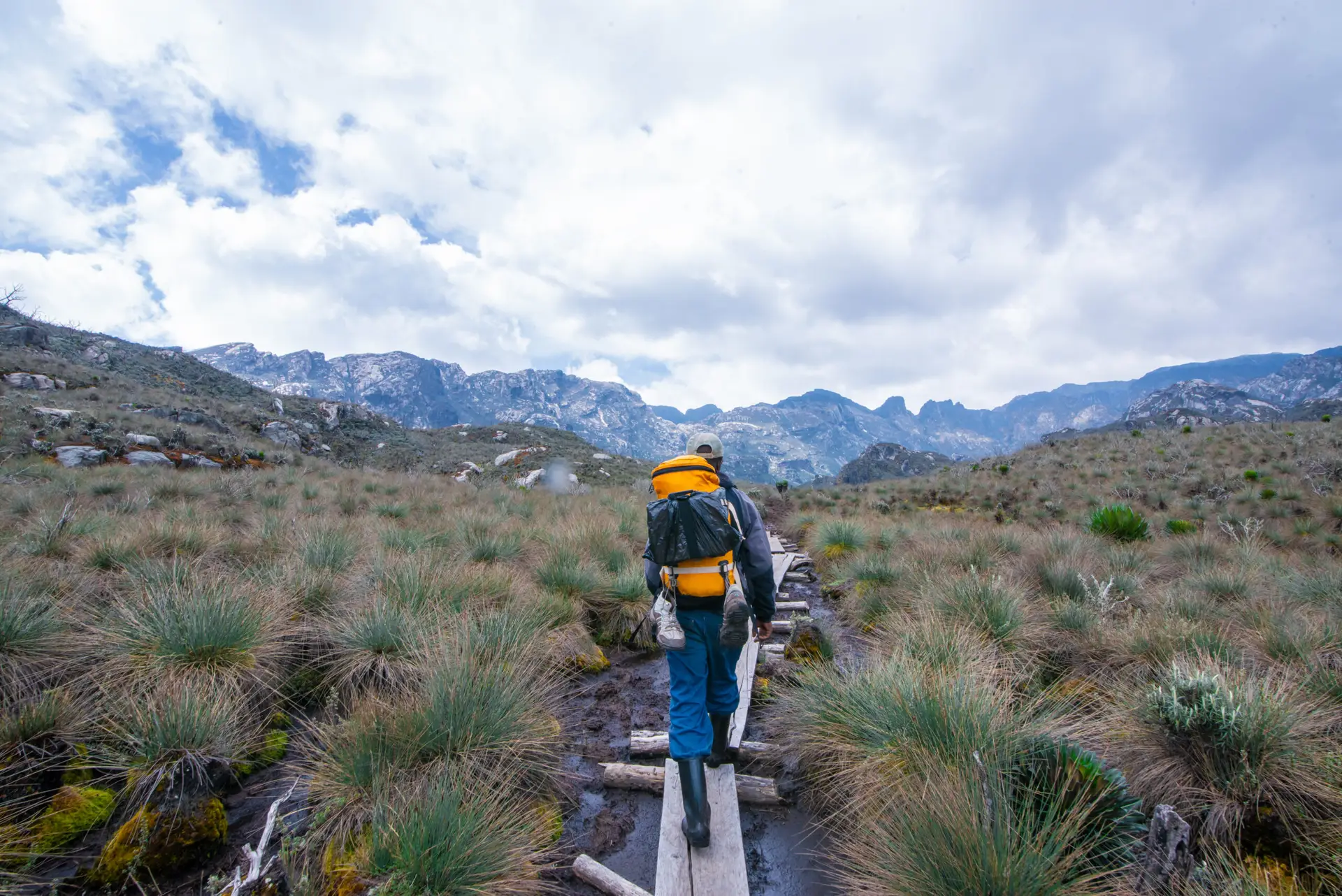
The path progressively ascends through the forest, passing beneath moss-covered rock outcrops and across multiple clear mountain streams. If you’re interested in seeing a stunning waterfall surrounded by lush riparian woodland, take a brief side trip from the main trail to Enock’s Falls. The forest gets deeper and the gradient gets steeper above the falls. Patches of bamboo emerge at elevations more than 2,000 meters, marking the beginning of the transition zone. In a sheltered clearing next to a stream, surrounded by tree heather that is starting to peek through the top bamboo, you will reach Sine Camp (2,596 m) after 6-7 hours.
Day 2: Sine Camp → Mutinda Camp (2,596 m → 3,588 m) | ~6.1 km
Hiking time: 5–7 hours | Elevation gain: +992m | Overnight: Mutinda Camp (3,588 m)
Into the Bamboo and Heather Zones
Even though it’s a shorter day, the second ascent of Weismann’s Peak is very strenuous in terms of both elevation gain and ecological diversity. The track soon ascends into heavier tree heather (Erica arborea and Erica trimera) after breakfast at Sine Camp, leaving the upper bamboo behind. This woodland, which is characterised by the Rwenzori between 2,800 m and 3,500 m, is gnarled and lichen-draped. The forest is always damp, with light streaming through pale green fronds, while usnea lichen, sometimes known as “old man’s beard,” droops from every branch. It is common to see three-horned chameleons (Trioceros johnstoni), a species native to the Rwenzori region, perched on heather branches at eye level in this area. Take it easy and keep a close eye on the plants.
Along its course, the trail ascends and descends a succession of ridges, providing progressively better vistas of the Nyamwamba Valley, Kasese, and, on fine days, the escarpment of the western Rift Valley. In the lower parts of the Kilembe Trail, ridge crossings provide fleeting glimpses of panorama in an otherwise restricted mountain terrain, and they are among the most rewarding parts of the hike. The trail descends into valley folds between peaks, fording swift, crystal-clear streams that rush over moss-covered boulders.
Mutinda Lookout Acclimatisation Option
Surrounded by a mountain stream in a broad, protected basin of alpine heather, Mutinda Camp (3,588m) is situated. The acclimatisation walk to Mutinda Lookout (3,975 m), a ridge point 387 m above camp that offers one of the most extensive panoramic views from any non-summit point on the Kilembe Trail, is an optional activity offered by your guide following your arrival in the early to mid afternoon. Clear afternoon views from the lookout reveal the Rwenzori Mountains to the north and east, the town of Kasese far below in the valley, the shimmering horizon of Lake George, and the first hints of the lofty peaks that will be our targets over the next few days: Weismann’s Peak, Baker, and Stanley.
We highly recommend this acclimatisation walk. The single most effective technique for avoiding altitude sickness is the “climb high, sleep low” principle, which involves climbing to a higher elevation and then descending to a lower elevation to sleep. Implementing this approach without adding to the following day’s load is the 2-3 hour round journey to Mutinda Lookout and returning to camp. For the entire rundown on how to handle high altitude, read the Rwenzori acclimatisation handbook.
Day 3: Mutinda Camp → Bugata Camp (3,588 m → 4,100 m) | ~8.6 km
Hiking time: 4–6 hours | Elevation gain: +512 m | Overnight: Bugata Camp (4,100 m)
Into the Afro-Alpine Zone: Giant Lobelias and Open Valleys
On the third day of the climb, the Rwenzori loses its mountainous appearance and takes on an alien appearance, making it the most visually striking day of the climb. In the highlands above Mutinda Camp, the tree heather quickly gives way to open Afro-alpine moorland. Here you can find tussock grass, old peat bogs, and the incredible enormous plants that give the Rwenzori Mountains their unique botanical character. Standing at a height of four to five meters, giant lobelias (Lobelia wollastonii) catch the morning sun with their silver rosettes that contain water droplets. The vast moorland is adorned by architectural stands of giant groundsels, scientifically known as Senecio adnivalis. The space in between is filled with everlasting blooms, specifically Helichrysum stuhlmannii.
Upon entering the Namusangi Valley (at an elevation of around 3,840 m), the trail winds its way across the expansive Mutinda Valley. Once there, you’ll be treated to a succession of breathtaking waterfalls that plunge down steep rock sides. You can see some of these waterfalls from hundreds of meters away, and their sound will carry you minutes before they even reach you in the still mountain air. Suddenly, you feel dwarfed by the vastness of the landscape as you go from heather to completely open alpine terrain in the Namusangi Valley. Cloud shadows sweep across the open ground, and you get your first glimpses of Weismann’s Peak and the ridges that surround Bugata.
Arrival at Bugata Camp
Many hikers are taken aback to learn that Bugata Camp, at 4,100 m, is one of the most well-appointed high camps in the Rwenzori Mountains. They had anticipated a simple mountain hut after the more rugged lower parts of the Kilembe Trail. Solar illumination (unlike most high camps in the range), warm shower facilities, sleeping huts with bunk platforms, a kitchen and dining shelter, and, most importantly for this elevation, the ability to land rescue helicopters are all aspects of the camp. At 4,100 m, any evacuation becomes much more complex and expensive, therefore bring your insurance paperwork to this camp. Before you leave, make sure you check your coverage with our Rwenzori travel insurance guide.
The views from Bugata are breathtaking, with the valley below reflecting Lake Kopello. To the north, the sharp peak of Weismann stands up above the alpine meadow, while tomorrow’s crossing, Bamwanjara Pass, can be seen as a depression in the ridge to the east, framed by the ragged rock faces of the central massifs of the Rwenzori. Around Bugata Camp around sunset, you might occasionally glimpse the Rwenzori Red Forest Duiker (Cephalophus nigrifrons rubidus), a subspecies that is exclusive to these mountains. They emerge from the remnants of foliage to graze. The open area surrounding the cottages is inhabited by alpine choughs and ravens.
Day 4: Bugata Camp → Bamwanjara Pass → Hunwick’s Camp (4,100m → 4,450m → 3,974m) | ~8.3 km
Hiking time: 7–9 hours | Gain: +350 m to pass | Net descent to Hunwick’s: −476 m | Overnight: Hunwick’s Camp (3,974 m)
The Climb to Bamwanjara Pass (4,450m)
As you transition from the Kilembe approach side to the inner Rwenzori realm beyond, you cross the watershed on Day 4 of the Weismann’s Peak trek. Start your day with breakfast at 6:30 and be ready to hit the road by 7:00. Leaving Bugata Camp, the trail heads over a lengthy ridge to Bamwanjara Pass, which is 4,450 meters above sea level. The climb begins at camp and reaches 350 meters in three to four hours. At this height, the rocky, open terrain is particularly vulnerable to the full power of any storms that may be blowing across the range.
Located at the intersection of two ridges in the inner rock core of the Rwenzori, Bamwanjara Pass is a small saddle. At the pass, there is a little emergency shelter hut that can be used as a windbreak when the weather is bad. When weather permits, the pass offers one of the most breathtaking vistas of the whole mountain range. The western vista reveals the territory you have ascended since Kilembe, while the eastern and northern vistas reveal the opening of the inner Rwenzori. Mount Stanley, with its glaciers visible as white bands above the dark granite, dominating the horizon at 5,109 m; to the south, Mount Baker rises to 4,843 m. Looking straight ahead, you can see Weismann’s Peak with its distinctive blade profile.
Descent to Hunwick’s Camp via the Alpine Bogs
The trail descends into the inner Rwenzori valleys from Bamwanjara Pass, following the lines of high-altitude alpine bogs. These bogs are home to the Malachite Sunbird (Nectarinia johnstoni), a bird species unique to the Rwenzori and Virunga highlands, which uses the spikes of huge lobelia flowers for both breeding and food. Get up close and personal with this jewel-green bird at one of the most dependable sites on the Kilembe Trail. Gently approach the lobelia stands while you watch the sunbirds tend to the flowers. To prevent sinking into the peat, be careful on the well-established trail lines as you traverse the bog parts.
Perched on the edge of a deep valley, with a panoramic view of the surrounding mountain range, Hunwick’s Camp (3,974 m) is, according to some hikers, the most dramatically placed camp in the Rwenzori. There is a separate kitchen shelter and bed platforms that can accommodate 12–16 people in the hut. With nighttime lows ranging from -2°C to -5°C, Hunwick’s is the perfect place to wear every layer you brought. Get a good night’s rest after that hearty dinner. Tomorrow starts before sunrise.
Day 5: Weismann’s Peak Summit → Kiharo Camp (3,974 m → 4,620 m → 3,460 m) | ~13 km
Hiking time: 9–12 hours total | Summit gain: +646m from Hunwick’s | Descent to Kiharo: −1,160 m | Overnight: Kiharo Camp (3,460 m)
Summit Morning: Approaching Weismann’s Peak
The tour starts at five in the morning, when your guide will wake everyone up. Typical temperatures in Hunwick’s Camp (3,974 m) before daybreak range from -3°C to -6°C, and the air is cold and motionless. Before you venture outside, make sure you’re wearing all of your protective gear, including a thermal foundation, fleece, down jacket, shell, cap, and gloves. The climb to the peak starts in the beam of headlights around 5:30 or 6:00 in the morning after a hearty breakfast of biscuits and hot drink.
Mount Luigi di Savoia has two peaks—Sella Peak (4,627 m) and Weismann’s Peak (4,620 m). The most direct route to the peak from Hunwick’s Camp is via McConnell’s Prong, a rocky ridge. Surefootedness is required because to the steep and rocky terrain, although technical roping and glacier travel are not necessary. This is not a challenging climbing goal, but rather a high-altitude trekking peak. The main obstacle is the altitude: at 4,500 meters or higher, you will experience the sensation of thin air with each step. Your greatest asset will be the guide’s rhythmic, calm, and methodical pace.
The Summit: Weismann’s Peak (4,620m)
The small rocky crest at the top of Weismann’s Peak is exposed on all sides. At the peak, you can see Mount Stanley’s Margherita Peak (5,109 m) clearly above the clouds to the northwest, and the glaciated ridges of Freshfield Pass and Mount Baker’s Edward Peak (4,843 m) to the south. Looking down, you can see the Kitandara Lakes basin, a valley that has been famously carved by glaciers, shimmering in the morning light. This is one of the best views in the Rwenzori range. The Virunga volcanoes can be made out in the distance to the southwest, over the border into the DRC, on very clear mornings.
You won’t want to spend more than 20 to 40 minutes at the peak due to the cold, wind, and demands of the day’s descent. Taking pictures, feeling a surge of righteous pride, and then tumbling downhill. Stand at 4,620 meters on Weismann’s Peak, the eleventh highest peak in Uganda; for the vast majority of hikers, this is the pinnacle of their mountain-climbing experiences.
Descent Through the Kitandara Valley to Kiharo Camp
Starting at the peak, the trail descends into the upper Nyamwamba Valley through the breathtaking Kitandara basin, a breathtaking alpine valley in the Rwenzori Mountains. Located in a bowl formed by glaciers at an elevation of about 4,023 meters, the Kitandara Lakes are also reachable via the Central Circuit Trail. On days when the weather is quiet, the dark water of these lakes remains unemotional. Around the lake, you may see lobelias and giant groundsels, and on three sides, you can see rock cliffs that have been shaped by glaciers. Many Central Circuit and Kilembe Trail hikers agree that the Kitandara basin is the most picturesque valley in the Rwenzori Mountains.
In the upper Nyamwamba Valley, the terrain flattens out and you can spot Rwenzori red forest duikers more frequently near the vegetation’s periphery as you make your way down via glacial moraines, old rockfall debris, and high alpine bog. As dusk falls, rock hyraxes can be heard calling from boulder fields. Nestled in dense evergreen forest by a gushing creek, Kiharo Camp (3,460 m) offers a welcome contrast to Hunwick’s exposed position due to its sheltering position. The peak is more than a thousand meters and several hours away by the time you reach it. Taking stock of everything that transpired today will require some mental space.
Day 6: Kiharo Camp → Nyamwamba Valley Exit → Basecamp (3,460m → 1,480m) | ~18 km
Hiking time: 8–9 hours | Elevation loss: −1,980m | End of expedition
The Nyamwamba Valley Descent: A Grand Finale
One of the most visually rewarding last days of any Rwenzori trip is Day 6, which is a long and arduous descent on the Weismann’s Peak excursion. A series of waterfalls, moss-covered rock faces, deep forest gorges, and several river crossings dot the Nyamwamba Valley valley, sculpted by glacial meltwater over millennia. Each one demands undivided attention, even when the legs start to tire. The technical hurdles were too great for McConnell to overcome in 1937 when he tried to descend this route without the current roadway. He thus turned back. Today, with the help of a knowledgeable guide and a well-kept footpath, the once-insurmountable path is now within reach.
The steep descent from Kiharo Camp starts right away, cutting through the subalpine zone and into the upper Afro-montane forest. As one drops 100 meters in elevation, the amount of wildlife activity rises: As the canopy gets closer, you can hear the rumbling of chimpanzees, the colobus monkey, and rock hyraxes (Procavia capensis) populating every boulder field. Red forest duikers from Rwenzori are also spotted moving through the understory. After a long descent, a lunch break at Riverside Rock Shelter gives your legs a chance to relax before the last push to the valley exit.
Return to Basecamp
The last stretch of dense tropical forest is crossed by the Nyamwamba Valley as it opens up at the park boundary and the road connection leading back to Kasese. You can end your adventure in base camp, which is the Rwenzori Backpackers Hostel in Kilembe, or at the exit point in Nyamwamba, where a vehicle is waiting for you. In the best manner imaginable, the return to reality is jarringly different from the one you’ve spent the past six days in.
Get ready to pose for photos with your porter and guide, participate in the tipping ceremony (see to our Rwenzori tipping guide for details), and finally enjoy that refreshing beverage that has been nagging you since Bamwanjara Pass. You have the option to either continue on to Fort Portal for post-trek rehabilitation or transfer to Kasese for accomodation. Always behind you, vanishing into its own cloud, is the Rwenzori.
End of the 6-Day Rwenzori Trek to Weismann’s Peak Itinerary