7-Day Mount Emin Trek via Rwenzori Central Circuit (4,798m)
The 7-day Mount Emin Trek is a challenging, remote expedition up the 4,798-meter massif in the northern Rwenzori Mountains. This scenic Central Circuit route takes trekkers through steep bog valleys and towering groundsels to the Umberto (15,740 ft) and Kraepelin (15,720 ft) twin peaks.
Reach the summit of one of the least-visited mountains in Africa. Starting in an old forest and ending at the rocky peak of Umberto, 4,798 meters above the equatorial plains, this seven-day trek through the Afro-alpine heartland of the Rwenzori takes you via the glacial basin of the Kitandara Lakes and the ancient forest.
Embark on an unforgettable 7-Day Mount Emin Trek the Rwenzori Mountains and discover Mount Emin. In the midst of spectacular landscapes, lovely scenery, and a profound connection to nature, the trek is both challenging and rewarding. Enjoy breathtaking views of the varied flora and climate as you immerse yourself in a new and lovely location in the Rwenzori Mountains every day.
You will pass through the Rwenzori Mountain camps of John Matte and Nyabitaba as you go along this old Central Circuit path. Skul Cave and Lac de Luna are two places where it can go camping. Come explore the Rwenzori Mountains on this once-in-a-lifetime journey, whether you’re travelling with a group or by yourself.
Why Choose the 7-Day Mount Emin Trek?
Mount Emin is the most impressive of the six tallest peaks in the Rwenzori Mountains due to its high elevation, isolation, and dramatic geology. Situated in the southwestern quadrant of the massif, above the twin glacial Kitandara Lakes, Emin rises to 4,798 meters at its Umberto Peak, the fifth highest point in the entire range. The landscape is so alien that even experienced hikers at high altitudes have described it as unlike anything they have ever encountered. No one should expect to summit this mountain in a large group. Although most serious summit efforts go towards Margherita Peak and Mount Stanley, Emin is one of the most seldom climbed large summits in all of Africa—and that very rarity is part of its charm.
This peak carries the weight of history as heavy as its elevation; it was named after Eduard Schnitzer, who was known to history as “Emin Pasha.” Schnitzer was an Ottoman-born administrator of Equatoria province. His infamously troubled rescue by Henry Morton Stanley in 1887 brought the Rwenzori into the spotlight worldwide. In 1906, an Italian expedition led by the Duke of Abruzzi reached the peak of the mountain for the first time; this same group also reached the peak of Margherita Peak for the first time in recorded history. Even though that mission happened 120 years ago, only few mountaineers from throughout the world have climbed to the summit of Umberto Peak. Join them on the 7-day Mount Emin Trek with the help of our knowledgeable Bakonzo guides and an expedition that will take care of all the logistical details.
Starting in Nyakalengija, the seven-day ride travels westward at Scott Elliott Pass (4,372m) before descending to the Kitandara Lakes basin along the Central Circuit Trail, which is famous for its iconic sequence of ecological zones in the range. These zones include the Afromontane forest, bamboo belt, giant heather cathedral, and the complete Afro-alpine world. In order to reach the peak on day 5, hikers must conquer the rugged south ridge of Umberto Peak. Once at the top, they will be rewarded with breathtaking views of Mount Baker, Mount Gessi, the Kitandara Lakes below, and, on clear days, the snow dome of Mount Stanley to the north. Fewer than a hundred hikers make the journey up the Rwenzori each year, and even fewer make it to this peak. From a worldwide perspective, this is quite unusual mountaineering.
For those who wish to continue their adventure beyond Emin, our 13-day Rwenzori 6 Peaks Expedition comprises six summits in a magnificent tour of the entire range. Read our guide to the Central Circuit vs Kilembe Trail if you wish to compare the Mount Emin experience with other high-altitude Rwenzori targets before you decide.
7-Day Mount Emin Trek Itinerary
Day 1: Nyakalengija Trailhead → Nyabitaba Camp
Elevation: 1,646m → 2,652m | Distance: ~8 km | Hiking Time: 4–5 hours
Located around 22 kilometres northeast of Kasese town, at an elevation of 1,646 meters, Nyakalengija serves as the primary trailhead for the Central Circuit, where your 7-day Mount Emin Trek will commence. Your guiding crew will consist of members of the same Bakonzo families who have been leading hikers up this mountain for decades after you register at the Uganda Wildlife Authority gate; the path will lead you into the national park in no time. As the final patch of level terrain for days, the Nyakalengija trailhead is an exhilarating but manageable destination.
Through 8 kilometres of rooted and frequently muddy route, the course on Day 1 climbs quickly through the lower montane forest, attaining nearly 1,000 meters in elevation. Underneath the towering Podocarpus milanjianus and Hagenia abyssinica trees that make up the Afromontane forest here, you’ll find a plethora of blooming Mimulopsis, Impatiens, and Begonia species. In the center of the canopy, you should see a red-tailed monkey. As you go further into the jungle, you should hear the two-tone call of the Rwenzori turaco, the most visually arresting forest bird in Africa. Midway through the ascent, the trail crosses the Mubuku River using a log bridge just before the last ascent to camp. To get a detailed species overview per zone, check out our Rwenzori wildlife guide in its entirety.
The Central Circuit begins at Nyabitaba Camp, a cluster of huts situated on a broad ridge above the forest at an elevation of 2,652 meters. From here, hikers get their first glimpses of the Mubuku Valley below. All multi-day Central Circuit treks have traditionally utilised the camp as a staging site. The majority of hikers will feel little to no impact from the altitude at 2,652 meters, but the thinner air will force their bodies to work harder. Get ready for the busy days ahead with a hearty hot dinner, an early bedtime, and your guide’s evening briefing.
Impressions: crossing the Mubuku River on a log bridge, seeing Rwenzori turacos for the first time, and looking out over the Albertine Rift Valley and Kasese from the camp’s open ridge.
Sleep: Nyabitaba Camp (2,652m) shared hut dormitory, foam mattresses, toilet block
Day 2: Nyabitaba Camp → John Matte Camp (3,505m)
Elevation: 2,652 m → 3,414 m | Distance: ~8 km | Hiking Time: 5–7 hours
Starting in the montane forest and ascending through the bamboo zone and into the huge heather world above, Day 2 of the whole 7-Day Mount Emin Trek is one of the most botanically rich days. Starting at Nyabitaba, the trail descends for a short distance to cross the Bujuku River. Then, it starts a steady rise along the ridge, passing through a series of incredibly varied vegetation zones. It’s like going to another planet every time you climb. Discover more about the Rwenzori’s vegetation zones and the botanical transitions in our comprehensive guide.
At about 2,800 meters, you’ll start to encounter the bamboo section, which is framed by towering culms of Arundinaria alpina that drape a cathedral roof over the trail. Spoor and bark-stripping evidence typically suggests that this area is elephant habitat, however encounters with these majestic creatures are quite rare. At approximately 3,000 meters, the trail enters the entire gigantic heather zone, where Hypericum trees and Philippia make a sudden change from bamboo to a transitional heathland. Here, Erica arborea grows to a height of 8 meters and silver-grey lichen covers every branch. In this part of the trail, which is sometimes narrow and partly flooded, renting rubber boots in Kasese is a lifesaver.
Located at an elevation of 3,414 meters, John Matte Camp is situated in a heather zone clearing that is protected from the wind by high ridgelines on both sides. Among all the campsites on the circuit, this one offers a breathtaking sunset view: on sunny days, the northern heathers give way to the white, faraway peaks of Mount Stanley. Acclimatisation routine is important on this, your first night at real altitude: eat well, drink three to four litres of water, and don’t give in to the need to push yourself to the peak too early the following day.
Highlights: Bamboo forest crossing, first giant heather tunnels, Mount Stanley views from camp on clear evenings
Sleep: John Matte Camp (3,414 m) hut accommodation, shared facilities, cook shelter
Day 3: John Matte Camp → Bujuku Camp (3,962m)
Elevation: 3,414 m → 3,977 m | Distance: ~7 km | Hiking Time: 5–6 hours
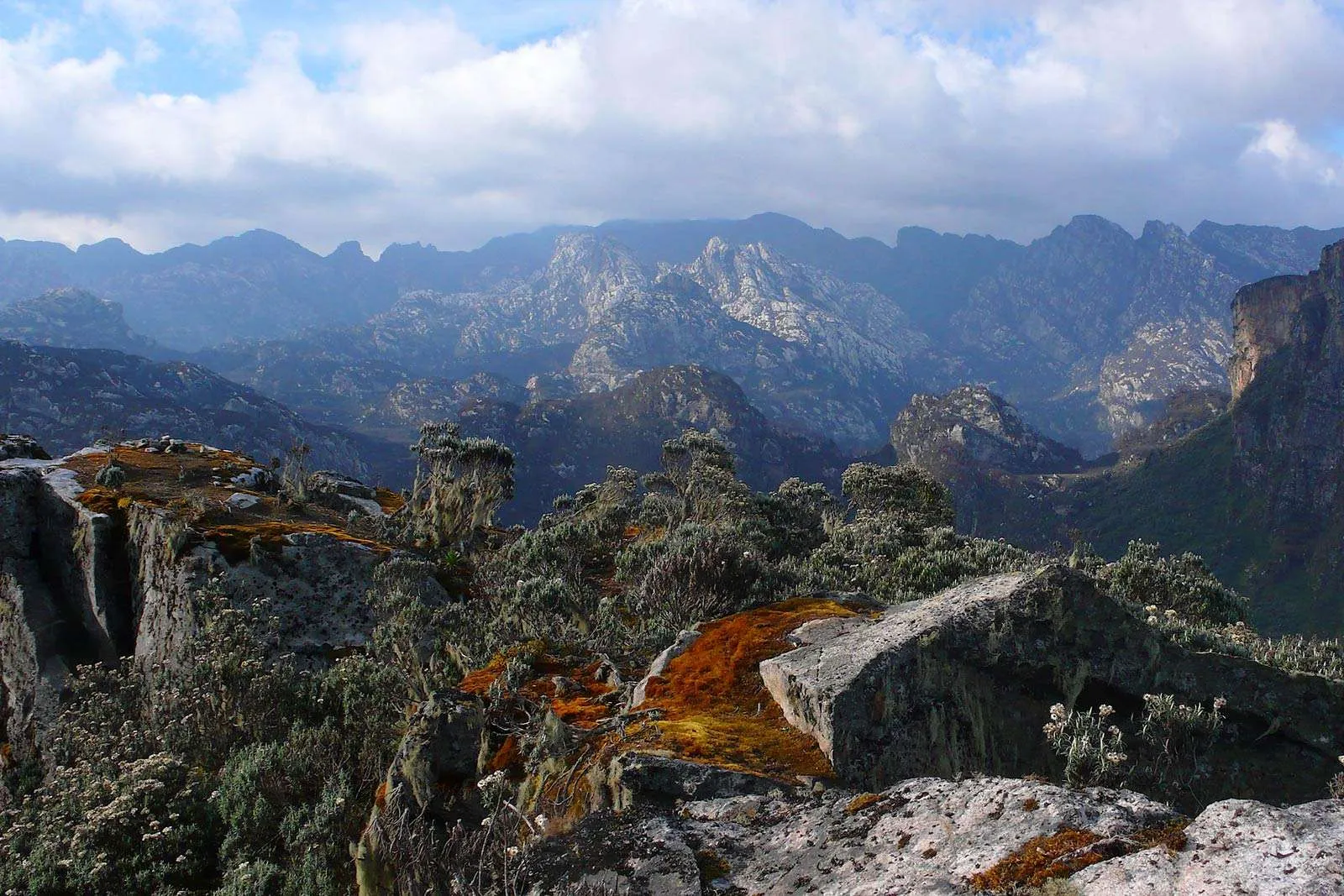
On Day 3, you’ll see the Rwenzori’s renowned alpine vegetation at its most vibrant. In the entire afro-alpine zone, the trail begins at John Matte and ascends through more open heathland. Along the way, you’ll see huge lobelias (Lobelia wollastonii) rising on columnar stalks from the margins of bogs and giant groundsels (Senecio adnivalis) appearing like botanical sculptures out of the mist. Adapted to the enormous diurnal temperature range of equatorial mountains—night frosts followed by intense daily solar radiation—are these plants found nowhere else on Earth at this height. They are the most recognisable feature of the Rwenzori Mountains and have been included in almost every photograph that has piqued the interest of trekkers in visiting the area. A comprehensive botanical breakdown is provided in our vegetation zones guide.
The route winds its way down from the heathland into the basin of Lake Bujuku, a much-loved mountaineering destination in Africa. When the clouds part, the tiny glacial tarn of Lake Bujuku (3,977 m) surrounded by swamp and gigantic groundsel reflects the snow slopes of Mount Stanley massif above. You won’t find anything like this in the Rwenzori’s forest zones; the setting is so primitive and undeveloped. An experience worthy of crossing continents is reaching the lake at first light, with the mist lifting from the water and a groundsel capturing the early sun.
As the final halt before the high passes, Bujuku Camp stands at 3,977 m, making it the highest camp on the classic Central Circuit. The shacks are simple but solid, and the amenities are enough. At Bujuku, the impacts of altitude can be felt by many in the form of headaches, disturbed sleep, and decreased hunger. During your ascent, your guide will keep a careful eye on how it’s going. Get as much water, food, and sleep as you can.
Highlights: Giant groundsel and giant lobelia zones, Lake Bujuku reflection views of Mount Stanley, and first experience of the full Afro-alpine world.
Sleep: Bujuku Camp (3,977 m) trail huts, shared facilities; a warm sleeping bag essential
Day 4: Bujuku Camp → Scott Elliott Pass → Kitandara Camp
Elevation: 3,977 m → 4,372 m → 4,023 m | Distance: ~7 km | Hiking Time: 5–7 hours
On the seven-day Mount Emin Trek, the fourth day is the most aesthetically stunning. At 4,372 meters, Scott Elliott Pass serves as a crucial juncture between the northern Stanley massif and the southern Emin-Gessi group; the trail begins its ascent from Bujuku at a sharp angle. Gaining approximately 400 meters in less than 2 kilometres, the climb to the pass is steep and frequently treacherous on wet rock. At the pass, you can see for miles in both directions: towering above you in the north are the ice cliffs of Mount Stanley’s Elena Glacier, while below you in the south is the vast valley of the Kitandara Lakes. One of the best vantage spots in Africa for mountain views is right here.
Although it is technically simpler to descend than to climb, hikers must be cautious of loose rock in dry weather and slippery mudstone after rain when making their way from Scott Elliott Pass to the Kitandara basin. At an elevation of 4,000 meters, the trail winds its way through verdant vegetation, changing from enormous groundsels to mossy banks and the initial Afro-alpine grasses. As the path descends, two deep, glacial tarns of exceptional purity, bordered by level swamp and crested by the rocky buttresses of Mount Emin to the east, become visible. The upper Kitandara Lake is at 4,023 meters and the lower is somewhat lower. On a sunny afternoon, the Rwenzori offers some of the most breathtaking shooting opportunities with its mirrored sky.
Perched on a level bench high above the upper lake, Kitandara Camp stands at an impressive 4,023 meters. The next morning, you will use this spot as your base for your summit attempt. Compared to the valley huts below, the camp is more exposed to the strong winds and often below-5°C overnight temperatures. Before dinner this evening, lay out and inspect all of your summit gear. After dinner, your guide will update you on the route and circumstances for Day 5. Get a good night’s rest before setting out for the peak around 5:00 AM.
Highlights: Scott Elliott Pass panorama (Stanley glacier + Kitandara basin), Kitandara Lakes reflection photography, evening Mount Emin skyline from camp
Sleep: Kitandara Camp (4,023 m) trail huts; sleeping bag rated -10°C recommended for summit night
Day 5: Summit Day — Kitandara Camp → Umberto Peak (4,798 m) → Kitandara Camp
Elevation: 4,023 m → 4,798 m and return | Distance: ~8 km return | Hiking Time: 7–10 hours
An early, chilly, and technically challenging event, summit day on the 7-day Mount Emin Trek rewards every step with panoramic views of growing majesty. Headlamps are required for the 5:00 AM dark departure from Kitandara Camp. To avoid the afternoon cloud cover and to finish the rough top sections when the rock is dry and hard instead of wet from morning condensation, it is best to begin hiking before dawn. This will allow you to reach the summit before the clouds roll in.
Climbing the southeast ridge of the Emin massif is the way to go from Kitandara to Umberto Peak (4,798m). Above 4,400m, the terrain becomes rockier, and the lower part passes over open marsh and scree. Strict hand-on rock climbing, cautious footwork, and right-side exposure characterise the scrambling above 4,500 m, when the summit ridge becomes narrow. While not technically glacier climbing, this requires a fearless attitude, sure footing, and confidence over steep rocky terrain. The parts that are the most exposed will have your guide at your side. On most days, you won’t need crampons when climbing Umberto Peak; nevertheless, your guide will check the weather forecast for the day of your hike to make sure.
Standing at 4,798 meters, the tiny rocky peak of Umberto offers breathtaking views of the entire southern Rwenzori and is surrounded by vertiginous drops on many sides. Looking west from 775 meters above, you can see the Kitandara Lakes in all their flat, unbelievable blue glory. At 5,109 meters, the snow dome of Mount Stanley stands tall and proud to the north. With its Bottego Peak prominently visible, the ridge of 4,715-meter Mount Gessi extends parallel to the south. In the direction of the Albertine Rift and central African plains, the expansive highland plateau gradually declines to the east. Clear mornings over the border reveal the hills of the Democratic Republic of the Congo. Very few individuals on this planet have ever seen the view from the summit like this.
Traverse back up the ascent route to reach Kitandara Camp. After a late lunch upon arrival, you’ll have the afternoon to relax and adjust to the higher altitude. Returning to camp from Umberto Peak requires a three- to four-hour descent. Give your weary body a break. Your legs will be tested to the limit on Day 6, a day of lengthy downhill.
Summit: Umberto Peak, 4,798m south ridge scramble; no glacier crossing required
Sleep: Kitandara Camp (4,023m) second night; recovery rest
Day 6: Kitandara Camp → Guy Yeoman Camp (3,261m)
Elevation: 4,023 m → 3,261 m | Distance: ~9 km | Hiking Time: 5–6 hours
The return arc of the circuit, which starts in the Kitandara basin and descends via the Guy Yeoman route through the southwestern arm of the Central Circuit, begins on Day 6. The trail ascends Emin from the lakes, crosses a lengthy ridge portion, and then begins a reverse descent through the vegetative zones. If anything, the flora and fauna change more dramatically on the descent than the climb: you re-enter the enormous heather tunnels from above, the groundsels dwindle behind you, and the air gets thicker and warmer as you descend.
At 3,261 meters, you’ll reach Guy Yeoman Camp after a steady descent that takes you past the Freshfield Pass area. With expansive views towards the central Rwenzori mountain, this camp is situated on a broad plateau above the Mubuku Valley. This is the last night in the real high-altitude zone, and it represents the halfway point of the trip. The camp is named for the surveyor of British explorer Major Charles Granville Bruce, Guy Yeoman. There is a kinder, warmer camp vibe here than at Kitandara or Bujuku thanks to the tree heather, hagenia, and first returning alpine species.
Your mountain guide team will examine the summit, the descent path, and answer any questions you may have about the Rwenzori’s history and ecology during a final mountain debrief this evening. Many hikers rank this night as their favourite of the whole journey.
Highlights: Descent through full Afro-alpine sequence, Freshfield Pass views, warm camp atmosphere at Guy Yeoman
Sleep: Guy Yeoman Camp (3,261m) hut accommodation, shared facilities
Day 7: Guy Yeoman Camp → Nyakalengija Trailhead (Final Descent)
Elevation: 3,261m → 1,646m | Distance: ~9 km | Hiking Time: 5–6 hours
On the last day of the seven-day Mount Emin Trek, you will slog your way back to the Nyakalengija Trailhead via the lower forest zones. Beginning at Guy Yeoman, the track descends gently for 9 kilometres, passing through a heather-to-bamboo transition, a thick montane forest, and ultimately emerging at the trailhead, a net descent of approximately 1,600 meters. Your knees and quadriceps will be working hard, so trekking poles are important.
On the way down, you’ll view familiar landscape through a new lens—the forest. It’s a change of scenery from the ascent. After days of high-altitude mineral landscape, the hornbills and colobus monkeys who welcomed you on Day 1 are back, and the air is thicker, hotter, and smells like forest flora again. Making one last ceremonial crossing of the Mubuku River log bridge is an emotional ordeal. Seeing the trailhead for the first time is an emotional roller coaster.
At the Nyakalengija gate, your lead guide will award you with a completion certificate. You will be transported back to Kasese by your vehicle. With the Kasese travel guide, you can enjoy a refreshing drink, a hot shower, and the pride that comes from conquering one of Africa’s most infrequently climbed summits. If you’re looking for an extended adventure, our 13-day 6 Peaks Expedition includes Mount Emin and five additional summits in the Rwenzori Mountains.
Highlights: Final Mubuku River crossing, forest re-entry, colobus monkey sightings, completion certificate at Nyakalengija gate
End point: Nyakalengija Trailhead (1,646 m); vehicle transfer to Kasese arranged as standard
End of the 7-Day Mount Emin Trek Itinerary