8-Day Rwenzori Trek to Margherita Peak via Kilembe Trail
The 8-Day Kilembe Trail trek to Margherita Peak (5,109m) is a challenging, scenically diverse route in Uganda’s Rwenzori Mountains National Park. Starting from the Kilembe base near Kasese, the standard guided itinerary provides excellent acclimatization as it ascends five distinct vegetation zones to Africa’s third-highest peak.
Best way to the peak of Mount Rwenzori. There are glacial lakes, waterfalls, stunning passes, and Africa’s third-highest peak along the southern trail, which is less travelled by hikers.
Eight days of Rwenzori trekking on the Kilembe Trail, culminating in a climb of Margherita Peak, are available from Rwenzori Trekking Services. Imagine setting out on a once-in-a-lifetime adventure to the magical Rwenzori Mountains in Uganda, often called the “Mountains of the Moon.” The eighth day of the Kilembe Trail allows mountain lovers and hard-core hikers to reach Margherita summit (5,109 m), the third-highest summit in Africa.
Rwenzori Trekking Experts are the only ones that can take you on this 8-Day Rwenzori Trek to Margherita Peak via Kilembe Trail. The seven nights spent in sustainable mountain lodges and camps in the heart of the Rwenzori mountains set this itinerary apart from the lengthier, more luxurious 10-day alternative that leaves from Kampala; it offers a genuine alpine experience.
Explore a wide variety of plant groups on this walk, from lush moorland to stunning glaciers, Afro-montane forests and expansive lobelia meadows. If you are seeking a challenging route away from the crowds that is also less crowded, the Kilembe Trail is a great option.
Take part in an unforgettable high-altitude trekking adventure in a breathtaking natural region of Africa. Its breathtaking scenery and abundant wildlife are second to none. Climbers with experience and those seeking an unforgettable African adventure will love our 8-Day Rwenzori Trek to Margherita Peak via Kilembe Trail.
An 8-Day Rwenzori Trek to Margherita Peak via Kilembe Trail through the breathtaking Rwenzori Mountains is in store for you. You will face numerous challenges as you travel through some of Africa’s most spectacular landscapes. In the “Mountains of the Moon” you can find glaciers, lush valleys, and a plethora of ecosystems. After pushing yourself to your physical and emotional limits, you will be rewarded with a beautiful panorama of the Rwenzori Mountains.
In the Rwenzori Mountains, the best-developed, most-beautiful, and diversified trail is the Kilembe Trail, sometimes called the Southern Circuit. Compared to the old Central Circuit, this hiking route, run by Rwenzori hiking Services (RTS), provides a more contemporary experience with improved infrastructure, cleaner cabins, and a more gradual ascent.
Ascending through five different vegetation zones, this trail starts in Kilembe, Kasese, on the foothills of the Rwenzori (1,450 m). It eventually reaches the glaciated high peaks of Stanley, Baker, and Weismann. The Kilembe Trail is most often used to reach Margherita Peak (5,109 m), and for good reason: it passes through some breathtaking scenery, including hanging valleys, clear lakes, dramatic bogs, steep slopes, and snow-capped summits.
Why Choose the 8-Day Rwenzori Trek to Margherita Peak?
The most visually diverse way to reach Margherita Peak (5,109 m) in the Rwenzori Mountains is by the Kilembe Trail, which is likewise called the Southern Circuit. Climbing through five biological zones, it eventually reaches the glaciated upper peak. It starts at 1,450 m in the historic copper-mining settlement of Kilembe, which is lower than any trailhead on the Central Circuit. The Kilembe route offers more to see than the 7-Day Central Circuit, and the extra day allows you to fully absorb it. The extra day is used to perfection in this case.
This route distinguishes out from the rest of the Central Circuit thanks to its high-quality infrastructure and dramatic terrain. Kilembe huts, run by Rwenzori Trekking Services (RTS), are among the most well-kept on the mountain; they’re more modern, spacious, and sturdy than a few of the older shelters in the Central Circuit. Along the way, you’ll come across some named landmarks that aren’t there when you come from the north: Enoch’s Falls, which are close to Sine Camp; the expansive Mutinda Lookout, which offers sweeping views of Kasese and Lake George from 3,975 m; the hanging valleys formed by glaciation above Bugata Camp; and the bird-rich Bamwanjara Pass, where Malachite Sunbirds feed on lobelia flowers at 4,450 m.
Additionally, the summit approach stands out. The Kilembe route places you at Margherita Camp (4,485 m), protected by massive boulders below Scott-Elliot’s Pass, instead of on the treacherous western shoulder of Mount Stanley, where you would normally ascend from Elena Hut. On summit day, at 2:00 a.m., you will traverse the Stanley Plateau Glacier using headlamps. Just as the clouds from the Congo begin to gather, you will descend on Day 7 via Oliver’s Pass and the Weismann Peak ridge, giving you a new angle on the upper mountain. The Rwenzori’s entire visual spectrum can be yours on the Kilembe Trail. See our Central Circuit vs. Kilembe Trail guide for a direct comparison of the two choices.
As a UNESCO World Heritage Site, the Rwenzori Mountains are home to the only remaining equatorial glaciers in Africa. However, experts anticipate that these glaciers will vanish totally by 2040 due to their rapid retreat. Visible areas of retreat include the Stanley Plateau ice and the Bamwanjara Pass glaciers, both of which the Kilembe Trail runs immediately beneath. Our article on the retreat of the Rwenzori glacier provides the complete background.
A Detailed 8-Day Rwenzori Trek to Margherita Peak Itinerary
Day 1: Kilembe Trailhead (1,450 m) to Sine Camp (2,596 m) | ~8 km | 4-5 hours
Kilembe is a small village at the base of the Rwenzori range in the southwestern part of Uganda. It is famous as the site of the country’s former copper mining. Your excursion starts at the Rwenzori Trekking Services base camp. You will register at the gate of the Rwenzori Mountains National Park and then enter the forest at an altitude of 1,450 meters after a comprehensive briefing, equipment check and porter assignment.
As it winds its way along the valley floor, the first trail passes through a dense afro-montane forest. Early birdsong fills the air in this lower belt, which is home to some of Uganda’s most diverse birdlife. As you make your way into the canopy, keep an eye out for blue monkeys and black-and-white colobus armies. It’s not uncommon to see groups of fifteen to twenty colobuses on this stretch, their coats flashing back and forth between the trees. Sometimes, from farther into the forest, you may hear chimpanzees barking. This portion of the trail feels completely different from any other in East Africa due to the warm and humid air, towering hardwoods coated in epiphytic moss, bamboo thickets, and floral vines.
The track is well-cut and the pace is pleasant, but the day’s elevation climb of 1,146 m is the hardest single-day rise on the schedule. The trail goes by Enock’s Falls, a multi-tiered cascade that drops into a clear plunge pool from moss-draped rock, some 200 m away from Sine Camp. On a sunny afternoon, it offers one of the most alluring opportunities for wild swimming in the park, and it is the first of numerous waterfalls along this path. A sturdy timber hut with views back down the valley toward Kasese, Sine Camp is situated at 2,596 m in the upper montane zone.
Day 2: Sine Camp (2,596 m) to Mutinda Camp (3,588 m) | ~8 km | 5-6 hours
The trail quickly ascends into the Bamboo-Mimulopsis Zone as soon as one leaves Sine Camp following breakfast. The path is bordered by dense bamboo, creating a maze of high-cut earth stairs that can climb treacherous in rain but are feasible with trekking poles. A transition into the Heather-Rapanea Zone is reached within an hour. Here, the vegetation opens up a bit and silver-grey curtains of Usnea lichen hang from twisted heather branches.
At 3,147 meters, Kalalama Camp provides a natural platform for a mid-morning rest stop and views of the Kilembe Valley in the distance. As you continue up the trail, you’ll see mossy ridges, little creeks, and waterfalls that fall right on top of you. Mist blows through the trees of the Namusangi Valley to the east, and the sound of water rushing never stops. There is no more atmospheric stretch of the Kilembe Trail in all of Uganda than this one.
Situated on a ridge at an elevation of 3,588 meters, Mutinda Camp offers unobstructed views of the upper Rwenzori. Those who choose to acclimatise by ascending to Mutinda Lookout at 3,975 m will be rewarded with one of the best range viewpoints. On clear afternoons, you can see the peaks of Mount Stanley, Mount Baker, and Mount Speke, as well as Kasese town and the shimmering expanse of Lake George to the south. By adhering to the climb-high-sleep-low approach, this afternoon acclimatisation trek significantly lowers your risk of altitude sickness on following days. In terms of insulation, dryness, and solar illumination, the huts at Mutinda are up there with the best of them along the Kilembe Trail.
Day 3: Mutinda Camp (3,588 m) to Bugata Camp (4,062 m) | ~7 km | 5-6 hours
As you enter the Afroalpine zone on Day 3, you will be entering the ecological core of the Rwenzori Mountains. This portion of the trail is often hailed by trekkers as the most visually stunning part of the first half of the journey. After winding its way up among perennial flowers and tussock grass, the path enters a valley populated by groundsel and enormous lobelias. One of the most striking examples of Afro-alpine gigantism on the planet may be seen in these ancient-looking plants, some of which reach a height of four meters. In contrast to other African mountain ranges, the Rwenzori vegetation zones condense hundreds of kilometres’ worth of altitude into a matter of vertical kilometres.
At an elevation of 3,840 meters, the trail leaves the Mutinda Valley and reaches the Namusangi Valley, where towering waterfalls plunge straight down from the mountainside into the surrounding marsh. The Mutinda Peaks create a striking backdrop when viewed from this vantage point. Sometimes the path to Bugata is swampy and you have to carefully navigate through tussocks, but your guide will show you the best ways. The compact and well-built Bugata Camp is situated at 4,062 meters above the expansive Nyamwamba Valley. Despite being exposed to the wind, the camp offers breathtaking views of the sky. Above Bugata Camp, on clear evenings, you can see some of the most vibrant stars of any camp along the trail.
Day 4: Bugata Camp (4,062 m) to Hunwick’s Camp (3,974 m) via Bamwanjara Pass (4,450 m) | ~9 km | 6-7 hours
Among the Kilembe Trail’s many spectacular days, this one stands out. Bamwanjara Pass, at 4,450 m, is the highest point you will reach on foot before summit day; the trail climbs sharply to get there from Bugata. Mount Baker (4,843 m), Mount Stanley (5,109 m), and Margherita Peak all appear sequentially across the Bujuku Valley on a bright morning, as seen from the emergency shelter at the pass, which serves as both a waypoint and a natural viewfinder. When most hikers get a good look of the peak, it transforms from an abstract concept into a concrete location where they will stand in two days.
After descending from the pass into the Kitandara Valley, you’ll pass through lobelia meadows, evergreen thickets, and massive groundsel. Eventually, you’ll reach a swamp part that you’ll have to navigate through using tussock and stones. Here you can often spot the jewel-green Malachite Sunbird, a bird with a bent bill that lays its eggs in the tussock and subsists solely on lobelia flowers. Ascending to Hunwick’s Camp at 3,974 m, a hut situated on the brink of a broad valley with panoramic views toward Weismann’s Peak, McConnell’s Prong, and the southern slope of Mount Stanley, the descent continues. After what most hikers say was the most physically demanding day of the entire trip, dinner is served in the hut.
Day 5: Hunwick’s Camp (3,974 m) to Margherita Camp (4,485 m) | ~5 km | 4-5 hours
Day 5 is purposefully brief. Even though it’s only a short distance from Hunwick’s to Margherita Camp, today is all about mental and physical preparation. You will see the same glacial lake that you met on the Central Circuit route’s descent as you drop from Hunwick’s, cross the valley floor, and reach the turquoise waters of Lake Kitandara. On a peaceful morning, the tranquillity here is quite remarkable, and Kitandara mirrors the nearby ridgeline flawlessly.
The trail leaves Kitandara and ascends to Scott-Elliot’s Pass before continuing up the ridge to Margherita Camp. The camp, situated at 4,485 m, is intentionally positioned between large boulders that block the summit wind. This arrangement dates back to 1906, when the Duke of Abruzzi selected this very spot as his base camp on the first ascent of Margherita Peak. You can feel the place’s historical significance.
Have a hearty hot meal, get to the top by early afternoon, and pay close attention to your guide’s briefing. Team members will learn when to leave, how to properly use crampons and ice axes, proper rope etiquette while on the glacier, how to interpret weather reports from the Stanley Plateau, and what to do in the event that someone on the team has signs of altitude sickness while on the glacier. Before you hit the hay, make sure you have all of your gear ready: harness, helmet, gloves, balaclava, headlamp, summit layers, and bunkbag. Get in bed by 7:30 p.m.
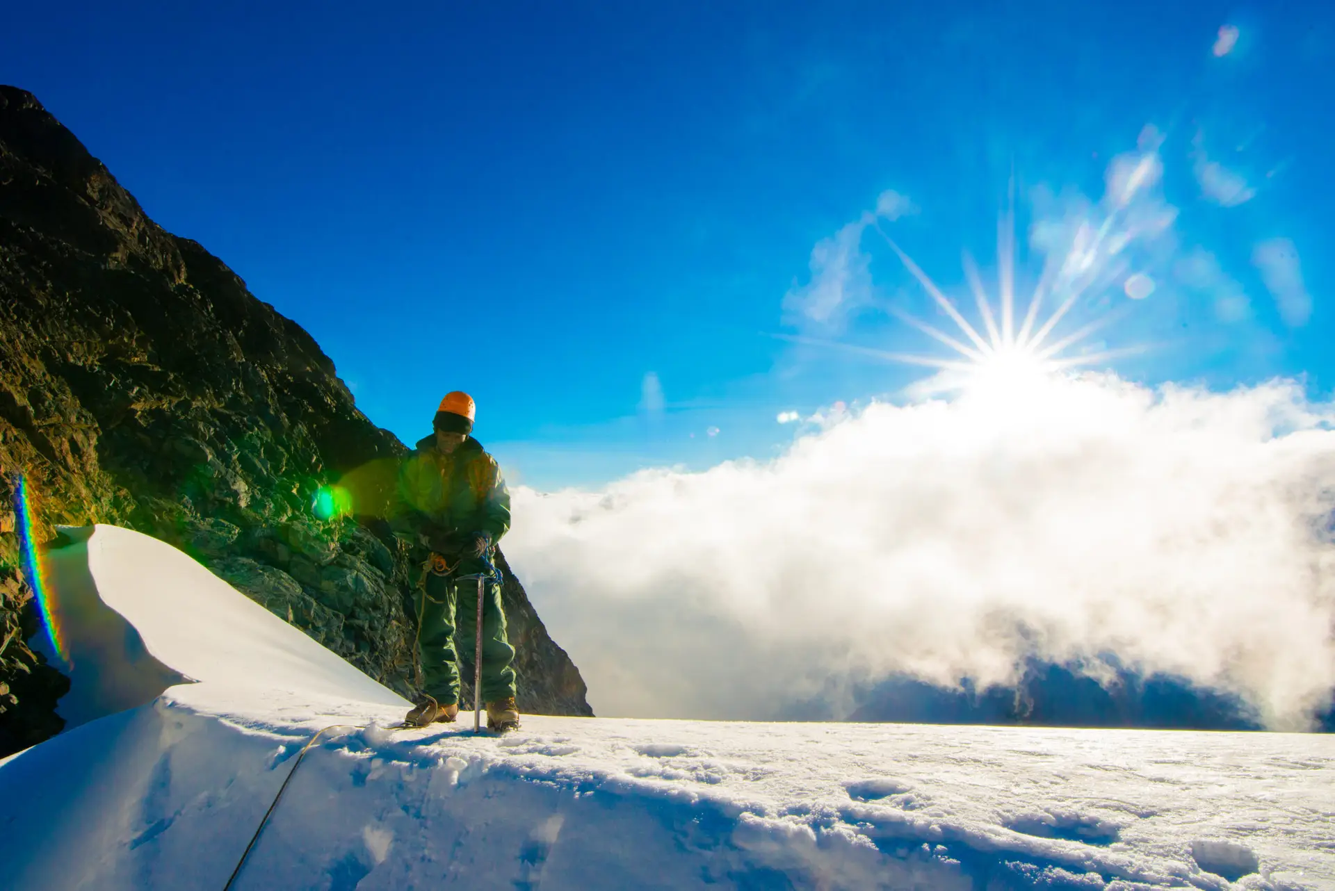
Day 6: Summit Margherita Peak (5,109 m) and Return to Hunwick’s Camp (3,874 m) | ~10 km | 10-12 hours
Be alerted at 1:45 in the morning. After a hasty breakfast in Margherita Camp, the summit party fastens their crampons and ropes to the glacier’s edge just before 3 o’clock in the morning, and then, with the help of headlamps, they venture onto the Stanley Plateau Glacier. As the sun rises, the temperature drops to a bone-chilling -10 to -15 degrees Celsius, and the presence of even a slight breeze makes the discomfort even more noticeable. Be sure to test and set up your layering system before you leave the hut. Our summit layering and cold-weather advice should be read before your trek if you haven’t previously.
You will traverse the crevassed ice field of the Stanley Plateau Glacier using the ropes that your guide has secured where necessary and the route that they have planned. Leading up the plateau onto the Margherita Glacier calls for ice axe-wielding front-pointing on steeper ice. With an experienced guide who has climbed this route more than a hundred times, even trekkers with no prior experience in mountaineering will be able to complete the ascent. Three to four hours is the usual time required to reach the 5,109 m summit of Margherita Peak from Margherita Camp. It needs little elaboration to stand atop Africa’s third-highest peak at daybreak, above the clouds that are just starting to form below you in the Congo Basin.
The two- to three-hour descent back to Margherita Camp follows photographs, a moment of calm, and reading of the summit register. Before continuing the descent to Hunwick’s Camp at 3,874 m, have lunch in the camp. Quick physiological relief upon descent to lower altitude is typical of evenings at Hunwick’s, where guests often report hearty appetites and a subtle sense of accomplishment. Here, the porters and guides have their own modest celebrations, and guests are welcome to watch.
Day 7: Hunwick’s Camp (3,874 m) to Kiharo Camp (3,460 m) via Oliver’s Pass (4,505 m) | ~12 km | 6-7 hours
Like its ascent, the Kilembe Trail’s descent follows a unique arc. The route from Hunwick’s Camp continues up a ridge towards McConnell’s Prong, where there are excellent views of the Three Peaks and Scott-Elliot’s Pass. After ascending to 4,505 m at Oliver’s Pass, the last high-elevation crossing of the expedition, the route then descends steadily via the valleys of the Kilembe and Nyamwamba rivers.
The descent passes a natural feature close to the confluence of the Nyamwamba and Kilembe rivers: a meandering ridge of stones and other debris left behind by glaciers as they receded. As a tangible remnant of the ice’s former extent down the mountain, this glacial moraine provides a powerful visual representation of the glacial retreat narrative described in our Rwenzori glacier guide. Below the moraine, the valley opens up, and the trail descends to 3,460 m Kiharo Camp, concealed in a valley encircled by heavy vegetation and rock walls. After the exposed upper camps, the camp feels comfortable and sheltered, shielded from the mountain’s enormous size. The quality of sleep is usually top-notch here.
Day 8: Kiharo Camp (3,460 m) to Kilembe Trailhead (1,450 m) and Kasese | ~19 km | 6-7 hours
A steep but pleasant descent of 19 kilometres separates Kiharo Camp from the park entrance and Trekkers Hostel. At first, the path hugs the riverbank; as you descend, the woodland rapidly encircles you. During the middle of the morning, visitors to this part of the park are most likely to observe the abundant Rwenzori red duikers, which are little antelope that often graze in the gaps next to the trail.
The river becomes more steep a few km farther downstream, and the valley is filled with the cacophony of a series of breathtaking cascades. After a short ascent to a high peak, the trail continues its descent through thick montane forest until it reaches the lunch halt at Forest View Camp. Returning to base camp takes the final hour over farmland and Bakonzo homesteads, retracing your steps from eight days previously but with a new perspective. You should be back at the Kilembe trailhead by mid-afternoon. If you made it to Margherita Peak, you can collect your summit certificate, return the borrowed equipment, and tip your porters. After that, most hikers stay the night in Kasese before continuing their journey.
Excellent extension potential are available from Kasese. The drive to Bwindi Impenetrable Forest National Park to see the gorillas takes about three to four hours. In less than 90 minutes, you may go straight south to Queen Elizabeth National Park. Our 12-Day Rwenzori and Gorilla Trek combo incorporates both adventures into one convenient schedule, perfect for trekkers who desire to experience the best of both worlds.
End of the 8-Day Rwenzori Trek to Margherita Peak Itinerary