8-Day 3-Peaks Rwenzori Trek (Mount Stanley, Speke & Baker)
The 3-Peaks Rwenzori Trek is an 8-day Rwenzori Expedition along the Central Circuit that summits the three highest massifs in Uganda’s Rwenzori Mountains: Mount Stanley (Margherita Peak, 5,109m), Mount Speke (Vittorio Emanuele, 4,890m), and Mount Baker (Edward Peak, 4,843m).
Summits that are highly sought for in Africa total three. A total of eight days traversing the entire alpine arc of the Central Circuit, from tropical forests to glaciers at an altitude of 5,109 meters. The best multi-peak trekking adventure in Uganda.
Finish the Rwenzori Mountains in just eight days by climbing three of its most famous peaks. You will reach the summits of Stanley, Speke, and Baker on this beautiful but difficult walk through forests, glaciers, and alpine valleys. Mount Speke, Stanley, and Baker are all part of our unique 8-day Rwenzori expedition.
Hiking the Rwenzori Mountains’ main peaks and a few of Africa’s highest summits in 8 days is what the 3 Peaks route is all about. As you make your way through verdant bamboo woods and towards the rocky bouldering peaks, get ready for an extraordinary adventure. The Rwenzori Mountains are home to several streams and rivers, and you’ll see glacial lakes and a plethora of other distinctive features as you make your way through them.
After you conquer Mount Stanley Margherita mountain, you’ll descend to Kitandara Camp and set out for the summit of Mount Baker. The first mountain you’ll encounter is Mount Speke. Every day and every peak is different, with spectacular views of sunrises and sunsets, stunning landscapes, and rough terrains. Embark on a captivating adventure that begs dedicated hikers to come along and unravel the profound sacred secret of the Rwenzori mountains.
After crossing the Mubuku River via the Kurt Shafer Bridge, hikers reach John Matte Camp, where they can take in breathtaking views of Margherita and Alexandria peaks, as well as Mount Speke (Vittorio Emanuele Peak), Mount Stanley (Margherita Peak), and Mount Baker (Edward Peak).
Continuing beyond the tranquil Lake Bujuku, the trail heads to Bujuku Camp, the starting point for the climb to Mount Speke, amid breathtaking landscapes dotted with towering huge lobelia. Vittorio Emanuele Peak, at 4520 m, is the destination of this difficult walk. Once this is completed, hikers will return to the camp and prepare for the next climb to 5,109 m Margherita Peak. Ascending Mount Baker is preceded by a descent to Kitandara Lakes Camp, following the conquest of Margherita.
8-Day 3-Peaks Rwenzori Trek Highlights
 There are treks like this and multi-peak adventures. Embark on an eight-day adventure across the Central Circuit Trail, which passes through every natural zone of the Rwenzori Mountains—from equatorial forest to active glacier—as you climb three of Africa’s most challenging and rewarding high-altitude summits. The circuit can be completed by reaching the summit of Mount Stanley at 5,109 m, which is the third highest peak in Africa and the location of one of the continent’s last equatorial glaciers. From there, you can return to claim Mount Speke at 4,890 m and Mount Baker at 4,843 m. You won’t find solace in these summits. The panoramic reward at the top of each mountain is unique, as is the strategy and technical difficulty required to get there.
The brilliant thing about this 8-day 3-Peaks Rwenzori Trek is how quickly it covers the whole range. The Central Circuit already traverses the base zone of all three peaks: the Elena Glacier in Stanley, Speke’s Vittorio Emanuele, and Baker’s Edward Peak. The former two are reached via spurs from the Bujuku Valley and Elena Camp, respectively, while the latter two are reached via the Freshfield Pass approach. Trekkers can reach three peaks at 4,800m+ and 5,109m without adding extra days or going backwards by incorporating summit days into the circuit’s natural pace. This is expertly planned adventure that showcases the extensive mountain knowledge of our Bakonzo guides, who have guided many trekkers to all three peaks.
Completing a three-peak traverse places you in an extremely exclusive club of mountaineers globally, since less than 1,000 trekkers venture to the entire Rwenzori range annually. Just so you know, every year, more than 50,000 hikers tackle Kilimanjaro. The Rwenzori is able to retain its untamed beauty and tranquillity thanks to its UNESCO World Heritage classification, the challenges of logistics, and the rugged terrain, all of which contribute to a low volume of visitors. There won’t be any other hikers around when you stand on Margherita Peak, which is 5,109 meters high, looking out over the Afro-alpine environment and the glaciated summit ridge. The peak is all yours.
Our 10-day 4 summits Trek now includes Weismann Peak, and our 13-day 6 Peaks Grand Expedition encompasses all six main Rwenzori massifs, perfect for trekkers who wish to extend their journey to five or six summits. Our comparison of the Central Circuit and the Kilembe Trail is the gold standard for hikers trying to decide which Rwenzori route is ideal for their goals.
A Detailed 8-Day 3-Peaks Rwenzori Trek (Mount Stanley, Speke & Baker)
Day 1: Nyakalengija (1,615m) → Nyabitaba Camp (2,651m)
Elevation: 1,646 m → 2,652 m | Distance: ~8 km | Hiking Time: 4–5 hours
The Central Circuit trailhead, located 22 km northeast of Kasese, is Nyakalengija (1,646 meters), where your 8-day 3-Peaks Rwenzori Trek commences. The track quickly enters the national park after you register at UWA and receive a thorough pre-departure briefing from your lead guide. You won’t see any level terrain for eight days after leaving the Nyakalengija trailhead. After a short moment of indulging, you’ll be ready to tackle the lengthy ascent into the lower montane forest.
From the very first day, the woodland is breathtaking. Underneath the dense understory of Podocarpus milanjianus and Hagenia abyssinica, you’ll find a profusion of flowering Impatiens and Mimulopsis species. Monkeys of the red-tailed and Colobus species soar through the treetops, while the red-tailed monkey quietly follows your every move. From its perch on the forest floor, the Rwenzori turaco cries out, its brilliant plumage making it seem almost man-made. At mid-elevation, the trail crosses the Mubuku River on a log bridge and reaches Nyabitaba in the late afternoon after a steady ascent. To find all species in the Rwenzori region, broken down by zone, check out our wildlife guide.
Nestled on a ridge at an altitude of 2,652 meters, Nyabitaba Camp offers breathtaking views of the Mubuku Valley below, the Albertine Rift to the west, and, just beyond the clouds, the peaks that you will ascend in the next four days. This is the first open vista of the trip thus far. An early night’s sleep, a hearty meal, and a rundown of the trip from your guide. Just eight days to go.
A few highlights were crossing the Mubuku River, seeing colobus monkeys and Rwenzori turacos, and getting a first look at the Albertine Rift’s ridges.
Sleep: Nyabitaba Camp (2,652 m) shared hut dormitory, foam mattresses, toilet block
Day 2: Nyabitaba Camp → John Matte Camp (3,505m)
Elevation: 2,652 m → 3,414 m | Distance: ~8 km | Hiking Time: 5–7 hours
The second day traverses three ecosystems in one, moving from the montane forest to the bamboo zone and finally to the lower parts of the gigantic heather world. Our guide to the Rwenzori vegetation zones describes in detail the botanical evolution, one of the distinctive delights of the Rwenzori. First day of navigational challenges begins after Nyabitaba at the Bujuku River crossing, where log bridges straddle the flow but become treacherous in rain.
Sleep: John Matte Camp (3,414 m) hut accommodation, shared facilities, cook shelter
Day 3: John Matte Camp → Bujuku Camp (3,962m)
Elevation: 3,414 m → 3,977 m | Distance: ~7 km | Hiking Time: 5–6 hours
On the third day of the eight-day trek, you’ll encounter the most breathtaking botanical scenery: the full Afro-alpine zone. Here, bizarre shapes resembling giant lobelias (Lobelia wollastonii) and giant groundsels (Senecio adnivalis) emerge from the mist, giving the impression that you’re trekking through a science fiction landscape rather than a real mountain. These aren’t weird plants grown larger; in fact, they’re from different evolutionary branches that hit upon a common strategy—tall stature and a closed rosette to shield the growing tip from night frosts. The quantity and variety of this kind of vegetation is unparalleled anywhere else in Africa.
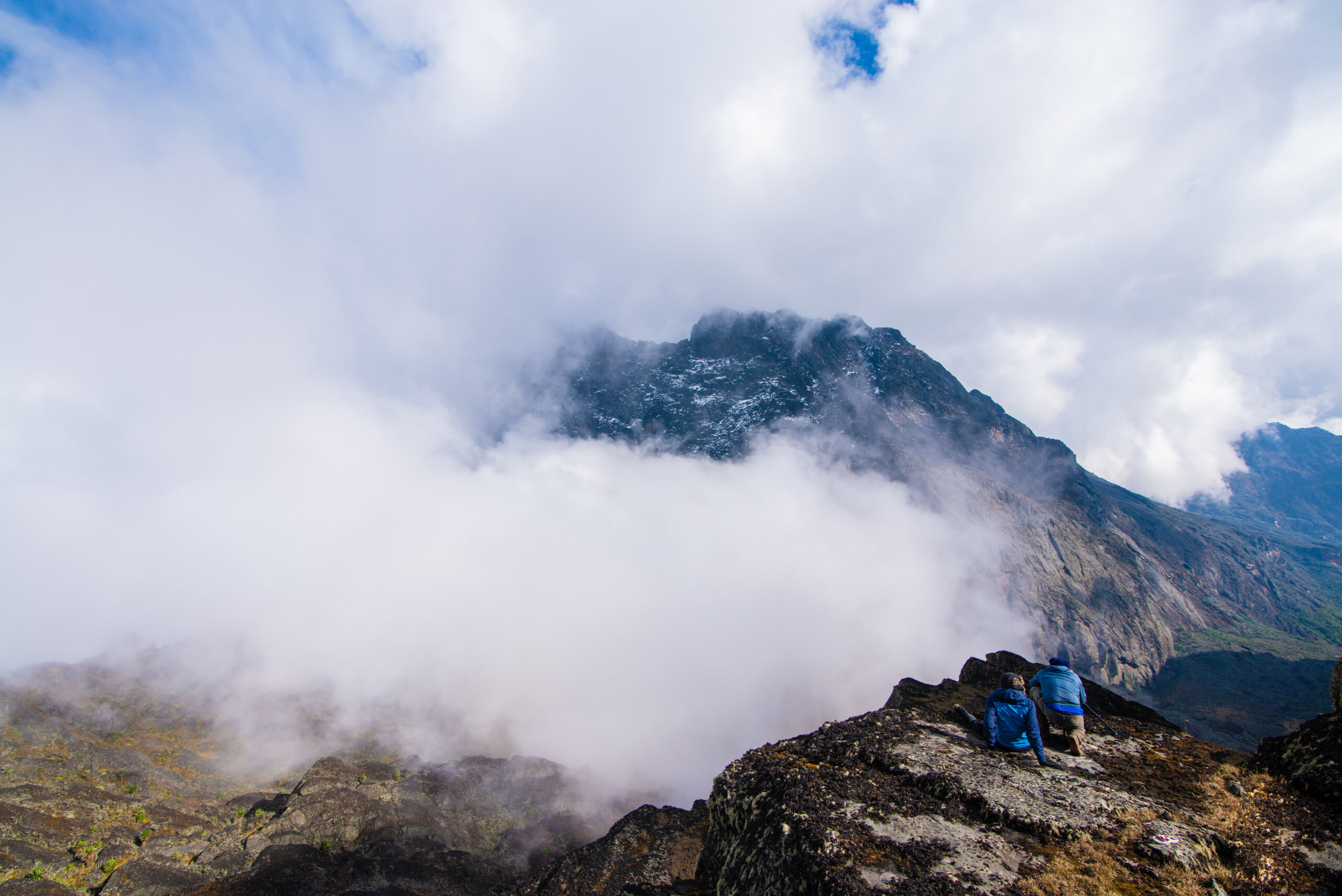
Upon reaching the peak of the hill, one is greeted by the breathtaking scenery of the Lake Bujuku basin, which can temporarily paralyse first-time visitors. On days 5 and 6, you will reach the summits of Mount Stanley to the northwest and Mount Speke to the north. The glacial tarn mirrors the slopes of both mountains. At this point, the journey takes on an intense, tangible quality; the peaks you have been striving for are now above you, enormous and distinct. Tomorrow, you reach new heights.
The highest class camp on the Central Circuit is Bujuku Camp, which stands at 3,977 m. Headaches, interrupted sleep, and decreased appetite are widespread and normalised here due to the true consequences of the altitude. Consume as much food as you can, stay hydrated, and get lots of sleep. This evening, your guide will make sure you’re adjusting well.
Amazing groundsel and lobelia zone, reflections of Mount Stanley and Speke in Lake Bujuku, and the first sight of Elena Glacier above
Sleep: Bujuku Camp (3,977 m) trail huts; sleeping bag rated -10°C essential from tonight onward
Day 4: Bujuku → Elena Camp (Acclimatisation & Stanley Summit Prep)
Elevation: 3,977 m → 4,541 m | Distance: ~4 km | Hiking Time: 3–4 hours
The short but important day 4 consists of the climb from Bujuku to Elena Camp (4,541m) below the Elena Glacier. Then, in the afternoon, you can recover, check your gear and get ready for the summit attempt of Margherita Peak on Day 5. On the southern slopes of the Stanley massif, the trail to Elena ascends sharply through the upper Afro-alpine zone. Here, the rock takes on the characteristics of a genuine high-altitude habitat and vegetation becomes increasingly sparse. The permanent snowline of the majority of the mountains in East Africa is now well below you.
Situated on a rocky bench beneath the glacier wall, Elena Camp is among the most spectacularly sited camps in mountaineering in Africa. Right above the hut, you can see the Elena Glacier; on sunny days, you can even make out the blue-white ice of the Stanley Plateau over the glacier’s nose. At this stage, your guide will go over proper ice axe technique with you, fit you with crampons, and distribute your glacier gear. In addition to the approach, the climb to Margherita involves traversing the Elena Glacier, which takes between two to three hours when roped. If you want to know what you’re walking on and why the Rwenzori glaciers will be gone in a few decades, read up on their vanishing.
in 4,541 meters, dinner in Elena Camp is a quiet, deliberate affair. Eat what you can, drink lots of water, and get some sleep early because your appetite will likely be drastically diminished at this altitude. Margherita departs about five or six in the morning, weather permitting. Get everything ready for evening.
Most notable: seeing the Elena Glacier for the first time, getting briefed and fitted for glacier gear, seeing Stanley Plateau from above camp, and taking in panoramic views of Bujuku Valley on the way up.
Sleep: Elena Camp (4,541m) summit base; sleeping bag rated -15°C recommended; extra insulation layers out
Day 5: SUMMIT DAY 1; Margherita Peak, Mount Stanley (5,109m) → Bujuku Camp
Elevation: 4,541 m → 5,109 m → 3,977 m | Distance: ~12 km total | Hiking Time: 8–11 hours
This journey represents the pinnacle of your existence. In the dark, between five and six in the morning, you and your guide will rope into groups of three or four and set off from Elena Camp. Bring an ice axe and crampons. It takes thirty to forty-five minutes to make the rocky moraine approach to the Elena Glacier; once on the glacier, everything changes to ice, wind, and the slow, methodical rhythm of crampon placement.
Margherita Peak (5,109m), the third-highest peak in Africa and the highest point on Mount Stanley, is reached by following the Stanley Plateau across the glacier and up to the summit ridge along the Elena Glacier. An expert navigator is needed to traverse the lower glacier’s crevasse field; your guide has done it dozens of times and knows the ins and outs. Careful footing is rewarded with a brief but exposed rocky section above the plateau on the final approach to Margherita. Next up is the peak.
Perched at 5,109 meters, Margherita Peak offers a panoramic view of the Rwenzori Mountains. Below you, at 1,100 meters below, are the Lake Bujuku basin and the Kitandara Lakes. To the southwest, you can make out the DR Congo hills, and to the west, you can see the Albertine Rift plains. On the Stanley mountain range, the neighbouring peaks of Alexandra and Albert may be made out to the northwest. Standing on a glacier that experts believe will vanish totally by 2050, you are on the third-highest point in Africa, right on the equator. Even if the cold just permits a brief moment on this top, it will be unlike any other summit moment on Earth.
After returning to Elena Camp from Margherita using the same glacier route, continue descending to Bujuku Camp (3,977 m) where you will spend the night. More over 1,100 meters of fall await you between the peak and Bujuku. Midway through the afternoon is when you may anticipate to reach Bujuku. You must have a hearty, hot breakfast and get to bed early since tomorrow morning is Peak 2.
Summit 1: Margherita Peak, Mount Stanley 5,109 m | Africa’s 3rd highest | Glacier traverse via Elena Glacier
Sleep: Bujuku Camp (3,977 m) recovery sleep after summit; post-summit fatigue is significant at this altitude
Day 6: SUMMIT DAY 2; Vittorio Emanuele Peak, Mount Speke (4,890m) → John Matte Camp
Elevation: 3,977 m → 4,890 m → 3,414 m | Distance: ~14 km | Hiking Time: 9–11 hours
On the sixth day of the expedition, the climbers face their toughest physical challenge yet: descending to John Matte Camp after a second summit push the morning after Margherita Peak. Those hikers who are physically capable of completing such a demanding sequence of summits in a row should not attempt the 8-Day 3-Peaks Trek. Not everyone should try it, but with the right preparation and time to adjust, it is doable.
Mount Speke’s Vittorio Emanuele Peak (4,890 m) is reached via an early morning ascent from Bujuku up the northern spur of the massif via the Stuhlmann Pass approach. Prior to reaching the rockier upper part over 4,500m, the route traverses wide Afroalpine country. Climbing to the peak of Mount Speke requires constant scrambling on solid granite, which is less strenuous than climbing Stanley’s Elena Glacier but more exposed due to the rough ridge trekking. From its 4,890 metre peak, Vittorio Emanuele offers breathtaking views to the south, across Lake Bujuku and the basin where you’ve spent the last three nights, and north, toward the border escarpment with the DRC.
The trail returns via the Bujuku Valley after reaching the peak of Speke, and then continues on to John Matte Camp (3,414m), where it will spend the night. This is a long downhill day, with a total movement of about 9-11 hours (including the peak), and the lower elevation of John Matte offers a significant physiological recovery night before the following day’s Peak 3. Get plenty of food and sleep, and the altitude loss will take care of itself.
Summit 2: Vittorio Emanuele Peak, Mount Speke 4,890 m | Rocky north spur approach from Bujuku Valley
Sleep: John Matte Camp (3,414 m) lower elevation recovery; warmer and physiologically restorative after back-to-back summits
Day 7: SUMMIT DAY 3; Edward Peak, Mount Baker (4,843m) → Guy Yeoman Camp
Elevation: 3,414 m → 4,843 m → 3,261 m | Distance: ~15 km | Hiking Time: 9–12 hours
The third and last day of the eight-day Rwenzori 3-Peaks Trek to the top. Beginning from John Matte Camp, the trail takes a completely different character than the Speke or Stanley ascents as it ascends to Edward Peak on Mount Baker (4,843 m) via the Freshfield Pass approach. The path leading to Freshfield Pass follows the Bujuku ridge in the south before climbing the Baker massif’s eastern slope. After a long day of hard scrambling on good, gripping rock, you’ll reach the summit ridge at an elevation of 4,600 meters.
The third-highest peak in the Rwenzori range is Mount Baker’s Edward Peak, which stands at 4,843 meters. Because there is no glacier and no roped team movement, the summit experience here is somewhat more intimate than the other two peaks; all that remains is a trekker, their guide, and a lengthy exposed ridge of ancient crystalline rock, from which one can see the entire Rwenzori panorama in all directions. The tops of Margherita Peak and Speke, which you ascended the previous two days, can be seen to the north. Without fail, guides notice the profound impact that vista has on hikers’ expressions.
The last night of the adventure is spent in Guy Yeoman Camp (3,261 m), which is reached after descending the Guy Yeoman trail from Baker. If you’re looking for a warmer, more sheltered recuperation camp, go no further than Guy Yeoman’s lower-elevation option. Your team debrief, tip distribution to your guide and porter crew, and the calm satisfaction of having climbed three of Africa’s finest summits should all take place this evening.
Summit 3: Edward Peak, Mount Baker 4,843 m | Freshfield Pass approach: rocky ridge scramble; no glacier gear required
Sleep: Guy Yeoman Camp (3,261 m) final expedition night; warmer temperatures, team debrief evening
Day 8: Guy Yeoman Camp → Nyakalengija Trailhead; Final Descent
Elevation: 3,261 m → 1,646 m | Distance: ~9 km | Hiking Time: 5–6 hours
In a reversal of the usual vegetation zones, the last ascent from Guy Yeoman to Nyakalengija descends around 1,600 meters through heather, bamboo, and montane forest. This descent will hit you in the quads and knees after seven days of high-altitude effort and three summit pushes. A set of trekking poles is a must-have. There is no rush; everything moves at a leisurely pace. When you return to the world you left behind, you’ll find a warm greeting from the forest, along with monkeys, birds, thicker air, and rising temperatures.
To prove that you have climbed Stanley (5,109 m), Speke (4,890 m), and Baker (4,843 m), your lead guide will offer you with a 3-Peaks Completion Certificate issued by Rwenzori Trekking Safaris at the Nyakalengija gate. Following your successful completion of one of the most challenging multi-peak adventures in Africa, you will be brought back to Kasese where you may enjoy a hot shower, cool beverages, and a great sense of accomplishment. Here is where the planning for the next adventure begins, be it the 13-day 6 Peaks Grand adventure or the 10-day 4 Peaks Trek.
Highlights: Forest re-entry through full botanical sequence, Mubuku River final crossing, 3-Peaks Completion Certificate at Nyakalengija
End point: Nyakalengija Trailhead (1,646 m); vehicle transfer to Kasese included
End of the 8-Day 3-Peaks Rwenzori Trek (Mount Stanley, Speke & Baker)