10-Day Rwenzori Trek | Mount Stanley And Mount Baker Hike
A 10-Day Rwenzori Trek | Mount Stanley And Mount Baker Itinerary. A combined itinerary for Mount Stanley and Mount Baker Hike follows a challenging 10-Day Rwenzori Trek expedition through the Rwenzori Mountains National Park in Uganda. In just ten days, you may reach the summits of Mount Stanley (5,109 m) and Mount Baker (4,842 m) via the Kilembe Trail in the Rwenzori Mountains. The finest mountain adventure in Africa with two summits.
Climb the Kilembe Trail to the summit of Africa’s third-highest peak and Edward Peak, Mount Baker. The Rwenzori Peaks Trek, which includes the summits of Mount Stanley (5,109 m) and Mount Baker (4,842 m), can be completed in 10 days by the most daring mountaineers. The “Mountains of the Moon” are a place of tranquil glacial beauty, abundant flora, and breathtaking scenery. There will be plenty of time for adjustment because this trip is slow.
A strange alpine landscape of lofty lobelias, valleys covered in moss, and clean mountain lakes awaits you after a slow ascent from Kasese via the Kilembe Trail, which winds its way through lush Afro-montane forests and bamboo zones. Using this method, you may ascend two of the highest peaks in Rwenzori. Camps will be strategically placed so that you may go on acclimation trips during the day and relax at night.
Mount Stanley And Mount Baker Hike Highlights
The Rwenzori Mountains are well-known as the “Monkey Mountains” of Africa. While there are numerous methods to visit these mountains, not many will let you climb both of their highest peaks in one trip. This is precisely what you’ll experience on the Kilembe Trail-based 10-day Rwenzori Trek. Along the way, you’ll pass the glaciated peak of Mount Stanley (5,109m), which is home to Africa’s third-highest peak Margherita, and the ice-capped Edward Peak (4,842m) of Mount Baker. This dual-summit trek is completed by less than a hundred trekkers annually.
The path is what really sets this walk apart. Rwenzori Trekking Services formally opened the Kilembe Trail in 2011, and the Uganda Wildlife Authority (UWA) oversees its management. It is a more recent, undeveloped, and immersive option than the traditional Central Circuit Trail. Professor Scott Elliot’s 1895 foray into these isolated valleys is the first in a long line of explorers that this trail follows. While most hikes on the Central Circuit follow a rather predictable loop, the Kilembe Trail winds its way through increasingly dramatic landscapes. It starts in a thick Afro-montane forest teeming with turacos and blue monkeys, then passes through bamboo groves reminiscent of cathedrals, ascends into ethereal Afro-alpine moorland with lobelias six meters tall standing over moss-covered bogs, and finally descends into glacial terrain, where each step is crucial.
The other notable benefit is the 10-day tempo. Your body will have plenty of time to acclimatise with nine nights on the mountain in this schedule. Skipping the heather zone in an effort to reach the peak is not an option. The Rwenzori motto “climb high, sleep low” is frequently used to properly locate each camp. On acclimatisation excursions, you will go to higher elevations before descending to lower campgrounds for a period of relaxation. Your body will be well prepared by the time you tie up on Day 5 for Mount Baker and again on Day 7 for Margherita, thanks to your plan.
You can’t think of this walk as just a summit-bagging expedition. Immerse yourself in one of the most remarkable and underexplored mountain ecosystems in Africa. Witness the visible retreat of the glaciers that once covered these peaks, see flora that is unique to this region, and let the profound silence above 4,000 meters reshape your thoughts. The 10-day Kilembe Trail walk is the one and only way to get a feel for the Rwenzori.
A Detailed 10-Day Rwenzori Trek (Mount Stanley And Mount Baker Hike)
Day 1: Kilembe Base Camp → Sine Camp (2,596m)
Distance: 9.5km | Elevation Gain: +1,146 m | Hiking Time: 5–6 hours
Located just a short drive from the garrison town of Kasese, the Trekkers Hostel in Kilembe (1,450m) is the starting point for your 10-day Rwenzori trip. Here you will meet your lead guide and porter crew, each of whom will be responsible for carrying up to 20 kg of equipment. Your gear will be checked to make sure it is mountain ready. The Kilembe Trail, the admission procedures to UWA Park, and the regulations of the mountain will be covered in detail before you put your daypack on and go out on the hike.
A short descent marks the beginning of the first part, which then begins a long ascent through dense Afro-montane rainforest. The canopy casts green shafts of light from the equatorial sun, the air is thick with dew and the smell of decaying leaves, and the route is a kaleidoscope of sounds that rivets the senses. The Rwenzori turaco, easily recognisable by its vividly flashing crimson wing patch, is a bird to keep a watch out for in the canopy. While three-horned chameleons cautiously grasp mossy trunks, blue monkeys slam through trees at medium height. You start to feel the trail’s notoriously rough terrain as you cross a suspension bridge across the Nyamwamba River.
About halfway through, you’ll come across Enock’s Falls, a wide and powerful waterfall that plummets from the nearby cliff. This spot is perfect for a natural break and will give you an idea of the immense hydraulic power of the Rwenzori Mountains. The mountains produce the most rainfall in Africa and feed the Nile River directly from their glaciers. As you ascend a few meters higher, the woodland gets denser and more moss-laden as you make your last ascent to Sine Camp. At an elevation of 2,596 meters, Sine Camp is situated in a clearing; the wooden huts there are situated above the treeline, while the forest remains nearby on all sides.
Meals: Packed lunch on trail. Three-course dinner and breakfast at camp. All food is prepared by your mountain cook.
Day 2: Sine Camp (2,596 m) → Mutinda Camp (3,582 m)
Distance: 6.1 km | Elevation Gain: +986 m | Hiking Time: 6–8 hours
The second day covers less ground, but it’s more taxing on the legs because the ascent from Sine to Mutinda is over a kilometre high. A dark, hollow-sounding, and profoundly atmospheric bamboo grove greets hikers as the path emerges from the top montane forest. A realm of old, unspoiled twilight emerges as the bamboo gives way to huge heather (Erica arborea) adorned with lichen beards that droop from every branch.
Consistently steep terrain characterises the Kilembe Trail at altitude, with surfaces ranging from packed earth and treacherous roots to the first stretches of mud and swamp. Now is the time to wear the rubber boots that Rwenzori Trekking Safaris provides. At the very core of the Rwenzori’s one-of-a-kind ecology is the heather and moorland zone, where the huge lobelias (Lobelia wollastonii) first emerge, their silvery-grey flower spikes soaring like frozen rockets over the underbrush. An alien silhouette of dendrosenecio (giant groundsel) trees, which can live for more than a century, punctuates the ridge.
As an optional side trip for acclimatisation, you can climb to Mutinda Lookout (3,975 m). It’s a short and difficult hike, but the view of the Kasese plains, Lake George, and Queen Elizabeth National Park stretching eastward is well worth it. The acclimatisation approach is as simple as exposing yourself to higher altitudes and then descending to sleep in Mutinda Camp (3,582m). Located on a wide ridge protected from the wind by a clump of heathers, Mutinda Camp offers a view of Mount Stanley’s glaciated sides in the northwest on clear evenings.
Meals: Hot breakfast at Sine. Packed lunch on trail. Dinner at Mutinda Camp.
Day 3: Mutinda Camp (3,582 m) → Bugata Camp (4,100 m)
Distance: 8.6 km | Elevation Gain: +518 m (with dips) | Hiking Time: 4–6 hours
On Day 3, you’ll venture farther into the high alpine zone of the Rwenzori Mountains by way of the breathtaking Namusangi Valley. Many hikers consider this day to be the most breathtaking of the whole journey because the valley is a corridor of breathtaking flora. Towering to heights of six meters, giant lobelias send their spiralling rosettes of succulent leaves aloft. The ridges and bogs are dotted with the ancient crowns of Dendrosenecio trees, some of which are said to be hundreds of years old. The open ground is carpeted in silver and gold by everlasting flowers (Helichrysum), the Rwenzori’s version of an alpine meadow.
Along its ascent along the valley’s sides, the trail passes under multiple waterfalls. During the dry season, the flow of permanent streams is limited, but after rain, the valley is filled with the sound of rushing water. These streams convey meltwater down from the glaciers above. Sections of the path vanish into mud that is ankle-deep or even knee-deep, and you’ll need to tread carefully on the wooden boardwalks (when they are present) since these bogs are real. We will put your rubber boots through their paces.
At 4,100 meters, on the ascent to Bugata Camp, the forest begins to thin out and the sky becomes more open. Overlooking the ridgeline, the first glimpses of glaciers emerge as seemingly endless white stripes on the rock. Perched on a natural platform, Bugata Camp offers breathtaking views of the distant peaks in the distance. As you go into the night, you’ll need to bundle up in your sleeping bag and thermal clothes because the temperature goes below freezing.
Meals: Hot breakfast at Mutinda. Packed lunch on trail. Hot dinner at Bugata Camp.
Day 4: Bugata Camp (4,100 m) → Hunwick’s Camp (3,974 m)
Distance: 8.3 km | Elevation Gain/Loss: +350 m / -476 m (via Bamwanjara Pass) | Hiking Time: 6–8 hours
The breathtaking mountain view is revealed on Day 4. After reaching 4,450 meters at Bamwanjara Pass, the trek’s highest point thus far, the trail descends to Hunwick’s Camp. On a sunny morning, the three highest Rwenzori peaks can be seen from Bamwanjara Pass: The glaciated peak of Margherita, the sides of Mount Speke, and the ice-draped Edward Peak of Mount Baker. This breathtaking alpine panorama is what makes the whole journey worthwhile.
Hikers must be cautious on the rough terrain as they ascend to the pass, which exposes them. In this part of the Afroalpine zone, you can find lichen-covered sections of exposed rock, cushion vegetation, and a few scattered little rosette plants. The pace decreases as a result of the substantially thinner air around 4,450m. If anyone in your party exhibits moderate to severe symptoms of altitude sickness, your guide will keep a close eye on them and instruct you to descend promptly. Drink regularly, go at a leisurely pace, and don’t force yourself to accomplish more than you can.
Glaciers that covered these mountains thousands of years ago are geologically evidenced by the landscape of glacially scoured rock and residual moraines as one descends from 3,974 m Hunwick’s Camp from Bamwanjara Pass. As the starting point for both the summit attempt on Mount Baker (Day 5) and the approach to Margherita Camp (Day 6), Hunwick’s Camp is an important base for the following two days due to its protected location. Have a healthy lunch, drink plenty of water, and spend the afternoon reviewing the summit-day briefing with your guide.
Meals: Hot breakfast at Bugata. Packed lunch at Bamwanjara Pass or on trail. Hot dinner at Hunwick’s Camp.
Day 5: Summit Day: Mount Baker, Edward Peak (4,842 m) | Return to Hunwick’s Camp (3,974 m)
Round Trip: ~8–10 km | Elevation Gain: +868 m | Summit Time: 6–9 hours total
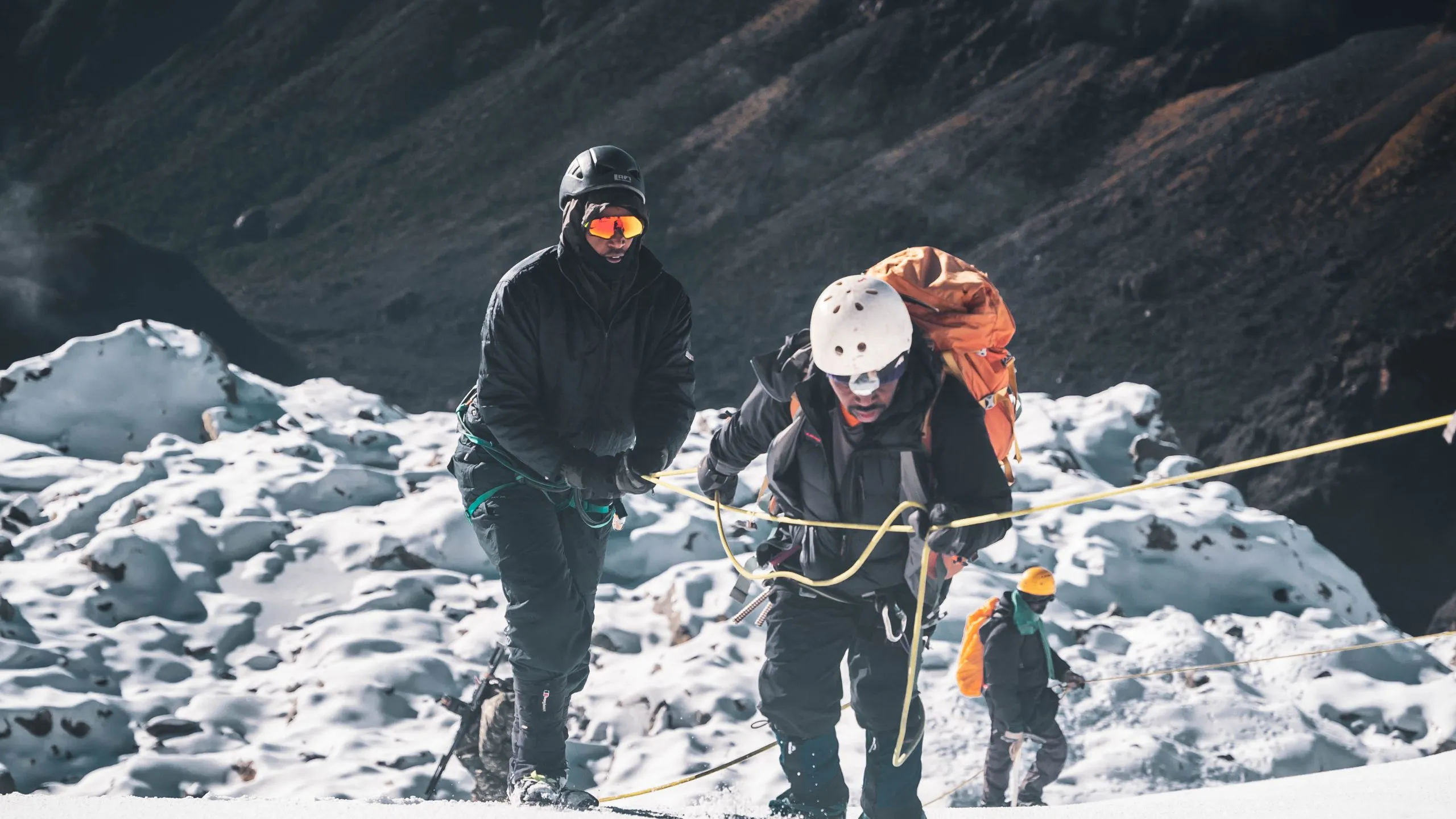
You start your first ascent attempt in the dark as soon as the alarm goes off in Hunwick’s Camp, which is usually around 4:00 or 5:00 in the morning. As the third-highest massif in the Rwenzori, Mount Baker (4,842 m) demands a steady ascent across rocky terrain and, depending on the weather, a brief glacial traverse to reach its peak, Edward Peak. Rwenzori Trekking Safaris provides a harness, ice axe and crampons, and your guide will go over their proper use with you before you begin your hike.
One of the most memorable parts of the hike is the ascent before sunrise. The only noises are of steady breathing, the wind, and the sound of boots on rock as headlamps illuminate the pitch-black sky above. At first light, the sky in the east becomes a kaleidoscope of pinks and ambers, and the twin peaks of Mount Stanley become visible in the distance to your left. The infamous Rwenzori mists frequently part with dawn, allowing for breathtaking vistas; the glaciers sparkle like a cold blue fire as they soak up the first light.
It usually takes two or three hours to descend down to Hunwick’s Camp. Make the most of your afternoon by actively refuelling, eating, and drinking. Ascending to the peak on Day 5 sets you up for the greater challenge on Day 7.
Meals: A hot breakfast before 5 a.m. departure. Packed summit lunch. Hot dinner at Hunwick’s Camp on return.
Technical gear: Crampons, ice axes, harnesses, helmets, and fixed ropes at key sections are all provided.
Day 6: Hunwick’s Camp (3,974 m) → Margherita Camp (4,485 m)
Distance: ~5.1 km | Elevation Gain: +511 m | Hiking Time: 4–6 hours
Keep in mind that Day 6 is a pivotal day. Lake Kitandara, one of East Africa’s most picturesque high-alpine lakes, is a stop along the way from Hunwick’s Camp to Margherita Camp, which is situated at 4,485 meters. At an elevation of about 4,023 meters, the lake stands in a chasm that was carved out by glaciers. On quiet mornings, the lake’s black water is absolutely tranquil, mirroring the granite cliffs above. It is a popular photo op along the Kilembe Trail and a lovely area to relax in nature.
Scott Elliott, an explorer who originally mapped these regions in 1895, is commemorated when the trail begins its arduous ascent from Lake Kitandara via Scott Elliott’s Pass. The pass, which is situated at an elevation of about 4,372 meters, signifies the change from the Kilembe mountain range to the area where Mount Stanley can be approached. Above Scott Elliott’s Pass, the landscape becomes more exposed and rugged, with sparse flora and the sound of wind becoming increasingly audible. A group of modest cabins known as Margherita Camp can be seen on a narrow shelf just below the terminal moraine of the glacier.
At 4,485 meters, Margherita Camp stands tall as the Kilembe Trail’s highest permanent camp. Every step must be taken with great care at this height. Severe symptoms like disorientation, incoordination, and blood in the cough are not common here, but the headaches and shortness of breath that come with being at a high altitude are. If it becomes necessary, your guide will choose to descend. Get some water, eat something healthy, and get some sleep tonight. Your alarm for the summit is scheduled to go off at four in the morning.
Meals: Hot breakfast at Hunwick’s. Packed lunch. Early hot dinner at Margherita Camp.
Day 7: SUMMIT DAY: Margherita Peak (5,109 m) | Descend to Hunwick’s Camp (3,974 m)
Distance: ~9 km round trip | Elevation Gain: +624 m | Total Time: 9–12 hours
The whole expedition has been preparing for this day. You are required to depart Margherita Camp in complete darkness at four in the morning, or even earlier if the alarm goes off. Starting at -5°C to -10°C, possibly even colder due to wind chill, your guide will lead the rope team up the first rocky part using a torch. Layer after layer comes off: undergarment, fleece for warmth, outerwear, balaclava, insulated gloves, and hardshell jacket and pants.
The sky becomes more luminous as you make your way up the glacier. One of those unforgettable moments is seeing the dawn break over the eastern flanks of the Rwenzori Mountains from this vantage point high above the Rift Valley bottom. The third-highest point in Africa, after Tanzania’s Kilimanjaro (5,895 m) and Mount Kenya (5,199 m), awaits trekkers who reach the 5,109 m top of Margherita Peak. On a sunny morning at the peak, you can make out the Rift Valley in western Uganda and the Virunga mountains in the Democratic Republic of the Congo.
Meals: Very early hot breakfast (3:30–3:45 am). Packed summit rations (energy bars, thermos drinks). Hot dinner at Hunwick’s on return.
Technical gear: Crampons, ice axes, harnesses, helmets, and ropes are all provided. Wear all thermal and waterproof layers.
Day 8: Hunwick’s Camp (3,974 m) → Kiharo Camp (3,430 m)
Distance: 15.8 km | Elevation Change: -544 m (with ridge sections) | Hiking Time: 9–10 hours
Day 8, one of the longest days of the climb in terms of mileage, is carried on by the post-summit elation. From Hunwick’s Camp, the trail drops down, crosses a high plateau that has been shaped by glaciers, and then goes across Oliver’s Pass. Looking south from Oliver’s Pass, you can make out the Weismann Peak massif on Mount Luigi di Savoia (4,627 m). Those following the 10-Day 4-Peaks route can make out a weak track leading toward the peak, but you’ll be descending into the Nyamwamba Valley system instead.
On Day 8, the landscape changes from historic glacier valleys to rugged ridge walks to the distinctive Rwenzori bog crossings. Even if it’s a good day, the path isn’t easy; perseverance and concentration are required to traverse an alpine bog while fatigued from two days of summiting. The enormous groundsel trees at this altitude have frequently been twisted into remarkable sculptural forms by decades of wind; the photographic opportunities are unparalleled.
Sheltered from the main winds, Kiharo Camp is at 3,430 m in a wider valley than the preceding sites. This relative warmth and shelter feels like a luxury after the three nights spent in exposed high camps. In the evening, once your mountain cook has cooked a hot supper, you may enjoy the ritual of taking off your boots, healing any blisters, and sharing summit experiences in the hut. These activities bring a profound sense of accomplishment that comes from working hard.
Meals: Hot breakfast at Hunwick’s. Packed lunch on trail. Hot dinner at Kiharo Camp.
Day 9: Kiharo Camp (3,430 m) → Kilembe Base Camp | Transfer to Kasese
Distance: 16 km | Elevation Loss: -1,980 m | Hiking Time: 6–8 hours
On the last day of the mountain, you’ll descend slowly through every type of vegetation found in the area, from heather to moorland, bamboo, and finally, the lower Afro-montane forest. With the river getting louder and the forest getting thicker by the hour, the Nyamwamba Valley takes you home; it is one of the most picturesque descending corridors in the Rwenzori. Small forest antelopes called duikers dart across the trail in the lower parts of the forest; monkeys called colobus arrive in the upper parts of the forest.
The Nyamwamba River is a tributary of the Nile, and its descent is punctuated by waterfalls that are supplied by the same hydrological system. The air thickens dramatically as you descend below 2,000 meters; the heat is nearly stunning after nine nights of cold in the alps. Upon reaching the end of the forest portion, the Kilembe Trekkers Hostel becomes visible; at this point, each party greets it with a distinct air of quiet.
When you get back to base, it’s time to shower, return technical gear, and tip your porters. Your transfer car will drop you off in Kasese town, which is about a 10-minute drive from Kilembe. There, you can find accommodations that have been reserved in advance. Before continuing their journey back to Kampala, Entebbe, or anywhere else they may be going in Uganda, many trekkers opt to have a celebratory dinner in Kasese.
Meals: Hot breakfast at Kiharo. Packed lunch on trail or at base. Dinner in Kasese (own arrangement).
End of the 10-Day Rwenzori Trek | Mount Stanley And Mount Baker