13-Day 6-Peaks Rwenzori Trek Expedition Guide
Trek All Six Major Rwenzori Peaks: Gessi, Emin, Speke, Margherita, Baker & Weismann on Africa’s third-highest peak at 5,109 meters
The 13-day 6-peaks Rwenzori trek is the ultimate grand expedition in Uganda’s Rwenzori Mountains. It covers six massifs—Mount Stanley, Speke, Baker, Luigi di Savoia, Emin, and Gessi—culminating in an ascent of Margherita Peak (5,109m). The journey requires advanced acclimatization and elite physical fitness.
This is not like other mountain treks. Among the many multi-summit trekking challenges in Africa’s Rwenzori Mountains, the 13-day 6-Peaks Rwenzori Trek Expedition is unrivalled. This route follows the entire length of the Central Circuit Trail and requires you to reach the peak of each of the six main massifs. After climbing six unique summits above 4,600 meters, traversing glacial crossings, camping in primordial fog, and witnessing a panorama that most trekkers on this continent will never see, you will descend from Weismann Peak on Day 13.
Unlike most Rwenzori treks, this one does not aim to reach a specific peak. Ascent to Margherita Peak, Africa’s third-highest peak at 5,109 meters, requires 13 days of trekking through one of the world’s most botanically remarkable mountain ranges, through bogs, heather woods, groundsel groves, and the Stanley Glacier. Skilled mountaineers, seasoned trekkers from East Africa, and those who wish to see the Rwenzori in its purest form are the types of people who go on this 13-Day 6-Peaks Rwenzori Trek expedition.
Annually, fewer than 1,500 hikers attempt the Rwenzori. Few even try to climb all six peaks. Join this adventure if you’re up for the challenge that the Moon Mountains actually present.
13-Day 6-Peaks Rwenzori Expedition Highlights
Unparalleled among mountain ecosystems on the planet is the Rwenzori Mountains National Park, a World Heritage Site designated by UNESCO. Tropical clouds envelop its summits all year round, giant heather and otherworldly lobelias cover its valleys, and true dedication is required to traverse its treacherous bogs. Only the 13-day 6 Peaks Expedition provides sufficient time to explore all of the mountain’s ecological zones, major summits, and moods.
You can get a sense of the magnitude of the undertaking by comparing this walk to the 7-day climb of Margherita Peak, which is already no small feat. A single summit objective is the center of attention on the shorter hikes. With this adventure, the whole mountain range becomes your playground. Weismann Peak on Mount Luigi di Savoia (4,627 m), Margherita Peak on Mount Stanley (5,109 m), Mount Baker (4,843 m), and Mount Gessi (4,715 m) are the six major massifs of the Rwenzori Mountains that you will surpass in a single uninterrupted traverse.
To top it all off, unlike other East African mountains, the Rwenzori is actually quite challenging. The going gets tough due to the technical and persistently wet terrain. All elevations experience frequent rainfall. Just getting across the bogs is a physical challenge. This is what makes the 13-day adventure such a compelling experience: every summit seems earned, every camp feels hard-won, and the landscape never loses its sense of wild, primaeval remoteness. For those who have summited Kilimanjaro and found it too crowded, too plain, or too predictable, the Rwenzori solves every one of those frustrations. Read our honest Rwenzori vs. Kilimanjaro comparison to discover the real difference.
The glaciers on these peaks are receding. Scientists anticipate that the Rwenzori’s equatorial ice will largely disappear by 2050. The 13-Day 6 Peaks Expedition provides, among other things, a rare chance to step on glacier ice in equatorial Africa while that possibility still exists. The urgency is real.
A Detailed 13-Day 6-Peaks Rwenzori Trek Adventure Expedition
Day 1: Nyakalengija Gate (1,650 m) to Nyabitaba Camp (2,652 m)
About 22 kilometres outside of Kasese town is Nyakalengija Gate, which serves as the expedition’s starting point and provides access to Rwenzori Mountains National Park. At the gate, you will be met by your guide team who will go over all the necessary pre-trek procedures, equipment checks, safety rules, and an overview of the mountain environment. Porters are also assigned and loads are dispersed here.
The walk begins at the gate and gradually ascends through a thick highland rainforest, the type of forest that is both ancient and vibrant. Several bridges, both wooden and steel, will carry you across rivers; one of these bridges will be above the Mubuku River canyon. Another will have you navigating a sequence of steep ladder parts bolted onto exposed cliff walls. Rwenzori animals abound in this woodland. Rwenzori red duikers’ calls can occasionally be heard from the underbrush, while olive sunbirds flit through flowering shrubs and Rwenzori turacos flash their crimson wings through the canopy.
At 2,652 meters, after around 4 or 6 hours of climbing, you’ll reach Nyabitaba Camp, a solid cabin situated on a ridge that offers breathtaking views of the Portal Peaks to the east. There is a dining area, a shelter for rudimentary cooking, and bunk beds in the camp. The camp takes on an authentically ethereal quality as the dusk mist rolls up the valleys below, and your mountain cook prepares dinner here. You start to get a feel for the next twelve days tonight.
Day 2: Nyabitaba Camp (2,652 m) to John Matte Camp (3,505 m)
The first half of the expedition is characterised by long and physically challenging days like this one. Shortly after breakfast, you will depart from Nyabitaba Camp and make your way down to the Kurt Schafer Bridge, a historic crossing place where the Bujuku and Mubuku rivers meet. One distinctive sound of the Rwenzori is the roar of the two rivers as they converge in the valley below. Take your time here; you won’t soon forget it.
The track begins its ascent from the bridge and enters the bamboo zone, a beautiful forest belt where it winds its way through thick stands of Arundinaria alpine bamboo. When you reach an altitude of around 3,000 meters, you’ll enter the hagenia-hypericum woodland zone, where you’ll see twisted heather trees covered in old man’s beard lichen. The terrain gets more and more muddy as you climb, and the air seems heavier with precipitation.
Before making the last push across the Bujuku River and up into the wide mossy woodland above, have a break at Nyamuleju shelter (about 3,100 m). Among the better-equipped huts on the Central Circuit Trail, John Matte Camp is situated at 3,505 meters and offers comfortable bunks, a communal dining area, and water from a nearby stream. One of the best camp views on the mountain is the one from John Matte, which, on a clear evening, offers a panoramic picture of the Rwenzori summits.
Day 3: John Matte Camp (3,505 m) to Skull Cave Camp (3,950 m)
As of today, you have crossed over into the real afro-alpine zone, leaving behind the lower mountain’s forests. Ascending from John Matte, the path winds its way through the Rupenia heather belt, an area of exceptional flora where heather trees reach heights of several meters and dense Sphagnum moss cushions the woodland floor. This is one of the most attractive parts of the circuit on clear mornings because the light filters through the heather canopy, making everything look green and gold.
Slow down if you’re trying to spot birds here. There are a lot of Rwenzori endemic bird species in this area, like the Rwenzori turaco, the lovely spurfowl, and the Lagden’s bush-shrike. At an elevation of around 3,700 meters, you can start to see giant lobelias, which stand out like sculptures on top of the heather with their gigantic rosettes.
At an elevation of around 3,950 meters, you’ll find the untamed camping spot known as Skull Cave. The area’s rock overhang has provided generations of campers with a mountain refuge. Tents are set up on the level ground beneath and surrounding the cave. Setting the tone for the upcoming peak days, this is your first experience with high-altitude wild camping on this excursion. Exceptional stargazing is possible at Skull Cave on clear nights. You should bring a sleeping bag with a suitable rating because the temperature will drop dramatically.
Day 4: Skull Cave Camp to Lac de la Luna Camp (4,100 m)
The trail begins its ascent into the upper Afroalpine zone at Skull Cave. When the heather dies down and the amazing tree-like plant known as giant groundsels (Dendrosenecio rwenzoriensis) takes over, the landscape is more stony and exposed. As a distinguishing feature of the Rwenzori landscape, these ancient-looking plants stand out due to their large rosette crowns and thick, cabbage-like trunks.
Views to the west, which open up as you climb higher, show the Democratic Republic of the Congo’s forested ridges over the Albertine Rift—a vantage point that very few hikers get to enjoy. The incredible height you have attained is put into context by the expansive green landscape that extends to the horizon on clear days, which consists of the DRC lowlands.
At an elevation of around 4,100 meters, surrounded by rocky outcrops and swampy terrain, lies the glacial lake camp known as Lac de la Luna. On calm evenings, the surrounding peaks are reflected on the lake’s quiet, dark surface. Here you will spend the first two days of your summit adventure. A warm, calorically dense supper will be waiting for you when you get at the lakeside tent sites.
Day 5: Summit Mount Gessi (4,715m), Return to Lac de la Luna
This is your first peak as an expedition leader. Iolanda Peak, the main peak of 4,715-meter Mount Gessi, requires a daring climb over boulder fields and scree. Starting from Lac de la Luna, the trail ascends steeply through stony moorland until reaching the summit ridge, where the last boulder-scramble awaits. As a Precambrian geological structure, the Rwenzori contains ancient crystalline schist, which offers secure hand and footholds for experienced scramblers.
Gessi offers breathtaking panoramas in every direction from its summit. The Congo Basin stretches out into the distance to the west. To the northeast, the higher Rwenzori peaks, Emin, Speke, and Stanley, form an imposing line of summits that you will visit over the days ahead. Spend some time at the peak before starting the equally taxing descent across rough rock, which is especially difficult for tired legs.
After a long day, head back to the Lac de la Luna camp for some much-needed relaxation. Tonight is a recovery supper and early rest. Mount Emin awaits tomorrow.
Day 6: Summit Mount Emin (4,798 m), Return to Lac de la Luna
The expedition’s second peak. At 4,798 meters, Mount Emin is an authentic alpine peak; its sides are steeper than Gessi’s, and the trail leading up the mountain passes through some of the mountain’s most verdant highland areas. Starting from Lac de la Luna, the trail winds its way through a succession of marshy valleys and rugged ridges, culminating in the last ascent to the peak of Umberto.
Exceptional vegetation zones can be seen on this climb. With their flower spikes reaching two to three meters above the Afro-alpine groundcover, giant lobelias stand sentinel across the highest slopes. The rocky ledges are carpeted with hazy gold and white everlasting blooms, often known as Helichrysum. Here you can find a zone that gives slow hikers cameras as a prize.
Unimpeded views of the main Rwenzori massifs to the south and east can be seen from the peak of Mount Emin. On days with good visibility, the glaciers of Mount Stanley can be seen from this vantage point, serving as a potent visual cue for tomorrow’s course of action. Bring all of your gear to Bigo Camp on Day 7 and descend gently to Lac de la Luna.
Day 7: Lac de la Luna to Bigo Camp (3,505 m)
A respectable day, and a pleasant break from the monotony of two straight summit pushes. Continuing south from Bigo Camp on the central Rwenzori plateau, the trail descends from Lac de la Luna into the upper heather zone and back into the transition forest, following the headwaters of the Bujuku drainage system.
The route requires continual vigilance due to the ankle-twisting footing and knee-deep mud crossings that are characteristic of the swampy tussock sections in the Bigo Valley, even though the majority of the journey is a descent. On this terrain, your rubber boots truly shine. The gigantic lobelias give way to dense heather scrub as you descend below 4,000 meters, and you’ll notice a noticeable change in the air temperature and humidity.
Mount Stanley, Mount Speke, and Mount Baker—the three highest points in the Rwenzori—form an impressive triple-headed skyline, and the views looking south from the path display all three in one panoramic sweep. Located in the wide, level Bigo Valley, with steep peaks on three sides, Bigo Camp is one of the most picturesque stops along the Central Circuit.
Day 8: Bigo Camp (3,505 m) to Bujuku Camp (3,977 m)
Bigo Bog, a huge, soggy plateau at around 3,500 meters, is one of the most recognisable and difficult parts of the whole Central Circuit, and it is traversed by the trail from Bigo Camp. While there are wooden boardwalks and stepping-stone trails to make your way around the bog, you will still have to wade through water and peat for a good portion of it. For this reason, rubber boots are distributed as standard equipment by the Rwenzori. This particular portion is often cited by even the most seasoned mountain hikers as one of the most exceptionally difficult they have ever encountered.
After crossing the bog, the trail continues its ascent, passing by the glacial lake of Bujuku at 3,977 meters, which offers a remarkable sense of tranquillity at such a high altitude. Eventually, it reaches Bujuku Camp, situated at the base of three majestic massifs. Because of its position beneath Stanley, Speke, and Baker’s merging faces, Bujuku is frequently said to constitute the emotional core of the Central Circuit.
One of the most breathtaking mountain vistas in all of Africa may be found from Bujuku Camp, facing southeast. Assuming clear skies, the sunset alpenglow will cast a pink glow across the glaciated summit ridges of Mount Stanley. You will ascend Speke tomorrow. Take it easy and get ready for tomorrow.
Day 9: Summit Mount Speke (4,890 m) Return to Bujuku Camp
At an elevation of 4,890 meters, this is the third expedition peak and the highest point you will have attained since your arrival on the mountain. Via Stuhlmann Pass and a difficult rocky ridge, climbers reach Vittorio Emanuele Peak, the principal summit of Mount Speke. The climbing path goes through some of the most breathtaking high-altitude scenery on the whole circuit, with cliff faces, snow patches, and expansive views appearing as you climb higher.
Starting at Bujuku Camp, the ascent to Speke’s peak is steep as it ascends into the boulder field that overlooks the valley. The German explorer Franz Stuhlmann, who conducted the first surveys of this region in 1891 and is hence known as “Dr. Stuhlmann’s Pass,” is the connecting link between Bujuku Valley and the higher Speke massif. Scrambling confidently on solid granite is required on the last approach to the top from the pass.
At 4,890 meters, Vittorio Emanuele Peak offers a breathtaking panorama that, on a clear day, almost covers the whole Rwenzori mountain range. Towards the southwest, the snow-capped peak of Mount Stanley stands tall. In the west, the Congo escarpment disappears. On sunny days, you can see the Ugandan plains stretching out into the distance when you look east. It is one of the best vantage spots in all of East Africa.
Day 10: Bujuku Camp (3,977 m) to Elena Camp (4,541 m)
Despite being shorter, the day was extremely taxing due to the high altitude increase and tricky terrain. The trail leaves Bujuku Camp and continues to climb steadily towards Scott Elliot Pass (4,372 m), the high col that separates the Bujuku and Kitandara valleys. It crosses the lower Bujuku bog again before reaching this point. Here you must traverse a swamp that is covered in dense tussock grass while dodging seasonal torrents. The sights are breathtaking, but the progress is painfully slow.
In order to reach the hut at 4,541 meters, the last portion of the trail from Scott Elliot Pass to Elena Camp ascends over airy boulder fields and groundsel forests, gaining an additional 170 meters. Located just beneath the glaciated upper slopes of Mount Stanley, the basic but sturdy hut known as Elena Camp is the highest permanent sleeping building on the mountain. You feel the immediate and profound impact of the glacier’s closeness here.
Something special happens that night at Elena Camp. You are scheduled to reach the Stanley Glacier tomorrow morning before sunrise. Check the fit and functionality of your glacier gear, including crampons, an ice axe, and a harness. It is early in the evening. By 7:30 p.m., the lights will go off. In the morning, between 2:30 and 3:00, your guide will wake up the rest of the group.
Day 11: Summit Margherita Peak (5,109 m), Descent to Kitandara Camp (4,023 m)
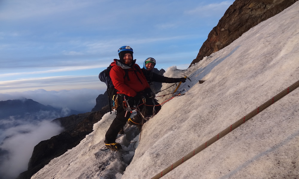
A central focus during the journey. Mount Stanley is the third-highest peak in Africa, and at 5,109 meters, the top of Margherita Peak is among the most remarkable and deserved summits in the continent. It is accessible only by traversing the equator’s permanent glacial ice, which continues to mystify even the most seasoned mountaineers.
Set your alarm for 2:30 or 3:00 in the morning. Energy bars, tea, and quick hot cereal make up breakfast. In the dark of the high altitude nights, we leave Elena Hut using only a headlamp. Beginning just below the hut, the trail winds its way across a boulder field before eventually skirting the summit massif’s huge snowfield and glacier system—the Stanley Plateau.
At the edge of the glacier, crampons are fastened. The group makes slow but steady progress on the ice in the gloom of morning, guided by your guide. Every so often, the glacier will moan under your feet. On a clear night, the stars over tropical Africa at 4,800 meters are indescribable.
Approaching the last rocky part below Margherita’s summit ridge, you can see the eastern horizon lightening up. The most technically challenging part of the entire adventure is the last 100 meters, which require steep climbing on a mixture of ice and rock. Just like that, you’re there. There on Margherita Peak. Under you, Africa. Over Uganda, the sun is just rising. Crystals of ice in your hair or beard. On the continent’s third-highest peak, there are six of you.
The ascent ends with a 20- to 30-minute summit stay for photographs, and then the fall starts. After descending the glacier, removing crampons at the moraine, and continuing on the picturesque traverse of Freshfield Pass, one of the most picturesque descents in the Rwenzori, you will reach the Kitandara Lakes basin. After what feels like an eternity of trekking, you will reach the magnificent twin Kitandara Lakes at an elevation of 4,023 meters.
Day 12: Summit Mount Baker (4,843 m) via Freshfield Pass, Camp at Freshfield Pass (4,282 m)
The culminating summit. The ascent to Mount Baker, which stands at 4,843 meters, begins at 4,282 meters at Freshfield Pass and continues northeast from Kitandara Camp, via the moraine that rises above the lakes. Seated on a breathtaking saddle of heather and exposed rock, the pass offers a breathtaking view of the Kitandara valley receding to the west and the Baker massif rising to the east.
From Freshfield Pass, the ascent to Edward Peak, Baker’s summit, requires treacherous scrambling over massive pieces of metamorphic rock. Even when wet, the ancient, solid granite here provides good traction. The last few meters leading up to the peak require a brief but perilous ridge traverse flanked by sheer cliff faces on either side. In this area, your guide will tie the group together if the weather allows it.
Mount Baker offers some of the best views in the range from its peak. Underneath, the Kitandara Lakes reflect the sunshine. Looking northwest, you can make out Margherita Peak, the same one you stood on yesterday. To the north, you can see Mount Speke. Before the descent starts in full force, this is the last outstanding viewing position of the adventure.
The wild camp on the pass’s windward side, with vast exposure to the valley systems below, is where you’ll be camping tonight, Freshfield Pass. When the clouds part, the view from Freshfield Pass at sunset is breathtaking.
Day 13: Summit Weismann Peak (4,627 m), Descent to Nyakalengija (1,650 m)
So, today is it. Finally, we reach the sixth and final peak. By continuing the traverse from Freshfield Pass east over the high ridge above the Mubuku Valley, one can reach Weismann Peak, the highest peak of Mount Luigi di Savoia at 4,627 meters. Although it is still a steep and clearly marked scramble over heather and rock to the exposed summit cairn, the climb to Weismann Peak is not as technically difficult as the previous two summits.
Gather around Gessi, Emin, Speke, Margherita, and Baker atop Weismann Peak, and mentally tally their names. After that, this one. Each of the six main mountain ranges in the Rwenzori. Get your camera ready. Take a moment to accept the truth. Your mountaineering journey in East Africa was among the most extensive.
Traversing the bamboo zone and returning to the outgoing route above Nyabitaba, the trail that descends from Weismann Peak retraces its steps to Freshfield Pass before continuing north via the Mubuku Valley track. The last leg returns to Nyakalengija Gate, the starting point of the trail thirteen days ago, along a descent through a thick montane forest. As you make your way out of the woodland, you might notice a change in its atmosphere.
To receive your completion certificate, you must reach Nyakalengija Gate by late afternoon. Guests of the Kasese lodge can arrange for a 30-minute ride back to town if they so desire. Those who have further travel arrangements can rely on our experts to help with transfers and other complications.
End of the 13-Day 6-Peaks Rwenzori Trek Adventure Expedition Guide