18-Day 8-Peaks Rwenzori Trek Expedition via Kilembe Trail
A 18-Day 8-Peaks Rwenzori Trek Expedition via Kilembe Trail. The 8-Peaks Rwenzori Trek is an intensive, 18-day mountaineering expedition to summit the eight major peaks of Uganda’s Rwenzori Mountains. It involves climbing Mount Stanley (Margherita, Albert, and Cheptegei peaks), Mount Baker, Speke, Gessi, and Emini. Hikers typically use the Kilembe Trail.
In just 18-Day Rwenzori Trek, you may reach the summit of each of the eight main Rwenzori peaks. On the most challenging mountaineering journey in Africa, you will pass through glaciers, alpine forests, lakes, and rough high-altitude landscapes.
Spend 18-Day Rwenzori Trek to the summits of the eight highest peaks in the Rwenzori Mountains with our tailor-made Rwenzori adventure. This hike to the Moon’s Mountains is best suited for those who have been trekking before. Now is the time to climb the Rwenzori Mountains! Climb all five peaks of Mount Stanley (Margherita, Cheptegei, and Albert Peaks) with Rwenzori Trekking Experts. Other summits include Baker, Speke, Gessi, and Emini.
Ascending the Kilembe Trail leads hikers through some of the world’s most biologically diverse mountain ecosystems, from dense Afro-montane forests to bamboo zones, enormous heather woods, swampy Afro-alpine moorlands, and eventually cold glacial terrain. The scenery, difficulties, and viewpoints of this spectacular mountain range change daily.
Only experienced mountaineers, adventure athletes, and trekkers should apply for this 18-Day 8-Peaks Rwenzori Trek, as it is one of the most challenging high-altitude circuits in Africa. It is lengthy, rough, and constantly satisfying. As a mountaineer, you should be proud of yourself if you reach the peak of all eight peaks.
The 18-Day 8-Peaks Rwenzori Trek is an elite, expedition-grade mountaineering adventure in Uganda. It tackles all the major peaks of the “Mountains of the Moon,” including Mount Stanley (Margherita, Cheptegei, and Albert), Mount Baker, Speke, Gessi, and Emini, generally accessed via the Kilembe Route.
18-Day 8-Peaks Rwenzori Trek Expedition Highlights
This is not like other mountain treks. One of the most unique, difficult, and satisfying mountaineering accomplishments on the African continent is the 18-Day 8-Peaks Rwenzori Trek Expedition, which involves climbing all eight main peaks of Africa’s Mountains of the Moon in one continuous trip via the Kilembe Trail. Annually, less than a hundred hikers undertake the entire eight-peak circuit. This is not a walk that just happens. Some people work toward this goal for a very long time.
From the Western Rift Valley’s tropical bottom to glaciated heights exceeding 5,100 meters, rise the Rwenzori Mountains (Rwenzori Mountains National Park, UNESCO World Heritage Site). This expedition aims to reach eight major summits in these six massifs: Stanley, Speke, Baker, Emin, Gessi, and Luigi di Savoia. Each massif has several subsidiary peaks. Between the trailhead and the highest peak, one can observe five different vegetation zones along the way. These include lowland Afro-montane rainforest, bamboo, giant heather, otherworldly Afroalpine moorland, and glaciated terrain, where one must be careful with each step. There isn’t another African mountain range that offers such a wide range of elevations in such a compact area.
It takes eighteen days to complete this mountain challenge, and it’s not because of artificial pacing; it’s because of the terrain, elevation, and amount of summit days. Attempting to reach the peak takes a whole day, and some of those days involve technical glacier travel. In order to go from one mountain range to another, hikers must negotiate inaccessible high-altitude passes, avoid glacial lakes, and descend into valleys formed by ancient glaciers. Over the course of the 17 days of hiking, you will gain an elevation of between 9,500 to 10,500 meters, which is roughly the same as climbing Kilimanjaro from sea level twice, but on far more difficult terrain.
Additionally, this journey is of the utmost importance. Scientists predict that the Rwenzori glaciers will have completely melted away by the year 2050, after having receded by more than 80% since systematic observations started. A privilege counted in years, not decades, is the opportunity to summit Margherita and Alexandra summits, the second-largest surviving tropical glaciated mountains in Africa, where the summit experience is defined by true ice. If you want to see the Rwenzori in all their glory before this unique ecosystem permanently changes, an 18-day trek is your best bet.
A Detailed 18-Day 8-Peaks Rwenzori Trek Expedition
Day 1: Kasese; Arrival, Equipment Check & Trek Briefing
Elevation: 914m (Kasese) | No hiking | Pre-expedition preparation day
The arrival in Kasese, the gateway town to the Rwenzori Mountains, marks the beginning of your 18-day 8-Peaks Rwenzori Trek excursion. Do not slack off today; the 17 days that follow will be safe and fruitful depending on how well you prepare. Meet your lead guide, an experienced mountaineer with certification from UWA who has led many successful multi-peak Rwenzori expeditions, as well as your extended support crew of guides, porters, and assistants.
On the first day, you will have to check all of your gear, both technical and personal, to make sure it meets the mountain’s specifications. Then, you will get a rundown of the weather forecast for the next 18 days, along with a route briefing and any backup plans. For your health and fitness, you will need to take a baseline blood oxygen saturation reading. After that, you will go over all of the necessary paperwork and permits. Lastly, you will get an orientation to the rules and regulations o In case you’re missing any essential gear, your guide may point you to the rental store in Kasese where you can get things like boots, waterproofs, and sleeping bags.
Take it easy, fuel up, and drink plenty of water in the afternoon. We suggest a hotel with a pool or garden so you can do mild stretching and calm your nervous system before your hike in Kasese. For more information, visit our pre-trek lodging guide. The mountains will start tomorrow.
Meals: Own arrangement in Kasese. Rest and hydrate. Early bedtime.
Day 2: Kilembe Base (1,450 m) → Sine Camp (2,596 m)
Distance: 9.5km | Elevation Gain: +1,146m | Hiking Time: 5–6 hours
A 12-kilometer (or 20-minute) transfer from Kasese will get you to the Trekkers Hostel in Kilembe, the designated departure location for the Kilembe Trail and this adventure. At the border of Rwenzori Mountains National Park, after you’ve gotten all your kit ready and your park permit stamped, you may start climbing through dense Afro-montane rainforest on the track.
On Day 2, the forest is breathtaking. The canopy is 30–40 meters tall and channels the tropical light into verdant and golden cathedral shafts. Blue monkeys and black-and-white colobus armies scurry loudly through the top branches, while three-horned chameleons cling to mossy trunks in the understory and Rwenzori turacos flash crimson wing patches through the middle canopy. A suspension bridge over the Nyamwamba River is crossed by the trail. Keep an ear out for the rumble of the rapid river gushing down the mountainside as you make your way up through a forest that is getting more and more covered in moss, until you reach the breathtaking Enock’s Falls.
The last two km to Sine Camp are challenging, steep, and totally worth it. At an elevation of 2,596 meters, you reach the higher forest edge, where the transition zone surrounding the huts is being overrun by tree heather. Hot and hearty, this dinner will set the bar high for the next sixteen evenings thanks to your mountain cook.
Meals: Packed lunch on trail. Hot three-course dinner and breakfast at Sine Camp.
Day 3: Sine Camp (2,596 m) → Mutinda Camp (3,688 m)
Distance: 6.5 km | Elevation Gain: +1,092 m | Hiking Time: 6–8 hours
In terms of elevation increase per kilometre, the third day of the adventure is the most challenging. You emerge from the woodland into the Rwenzori’s characteristic heather forest, where towering Erica arborea trees adorned with old man’s lichen (Usnea) cast a shadow that seems to go on forever, producing an ethereal twilight that seems to defy the passage of time. Root networks, wooden ladders at steep places, and the first real bog crossings will put your rubber boots to the test on this more difficult path surface.
Today marks the first notable emergence of the enormous lobelia (Lobelia wollastonii), a silver-grey splendour that can reach heights of five meters above the heather floor. Along the ridgelines you can see Dendrosenecio groundsel trees, which are hundreds of years old. Located at the peak of the main climb, Mutinda Camp (3,688 m) offers protection from the wind on an exposed ridge surrounded by heathers. Taking a little acclimatisation walk to a local viewpoint at 3,925 m provides a first view of the approaching massifs, which is a great way to boost morale and get your body ready for what’s to come.
Meals: Hot breakfast at Sine. Packed lunch on trail. Hot dinner at Mutinda Camp.
Day 4: Mutinda Camp (3,688 m) → Bugata Camp (4,062 m)
Distance: 8.6 km | Elevation Gain/Loss: +374 m (with valley traverses) | Hiking Time: 5–7 hours
You will enter the complete Afroalpine environment on Day 4. The Namusangi Valley corridor is a verdant haven, home to six-meter-tall lobelias, centuries-old Dendrosenecio groundsel trees, silvery-white everlasting flowers (Helichrysum), and cushion plants that populate the bogs in between granite outcrops. Because of the millions of years of evolutionary seclusion at equatorial height, this landscape is unique among all others on Earth.
The glaciers above feed a number of large waterfalls that dot the valley floor. With the valley opening out, the sky becomes much clearer, and we get our first look at the higher peaks’ glaciated slopes, which stand out above the ridgeline, like narrow white ribbons on dark Precambrian rock. Perched on a natural platform at an altitude of 4,062 meters, Bugata Camp offers unimpeded views of tomorrow’s first summit, Weismann Peak, as the sun sets. All thermal layers will be visible tonight as the sun goes down.
Meals: Hot breakfast at Mutinda. Packed lunch on trail. Hot dinner at Bugata Camp.
Day 5: SUMMIT 1: Weismann Peak (4,620 m) → Return to Bugata Camp (4,062 m)
Round Trip: ~8km | Elevation Gain: +558m | Summit Time: 6–8 hours
⛰️ PEAK 1 OF 8 — Weismann Peak, 4,620m (Mount Luigi di Savoia)
Your initial peak. Mount Luigi di Savoia has two summits, Sella Peak and Weismann Peak. At 4,620 m, Weismann Peak is the highest of the two and the southernmost of the Rwenzori’s main massifs. The trail begins in Bugata Camp and ascends rough terrain via an alpine swamp, eventually reaching the summit plateau via a network of ridges. A challenging but non-technical top, this route does not call for specialised glacier gear, making it a great psychological and physiological warmup for the more difficult summits to come.
From Weismann’s peak on a sunny morning, the Rwenzori spine is seen in all its glory for the first time: the northerly peak of Mount Baker, the glaciated summit of Mount Stanley beyond it, and the undulating moorlands below. Among the best in the range, the panorama is truly remarkable. Get back to Bugata Camp by mid-afternoon on the descent; then, gorge yourself, drink lots of water, and sleep it off. The journey has started seriously now.
Summit departure: 5:00–6:00am. Return to camp by early afternoon. Hot dinner at Bugata.
Day 6: Bugata Camp (4,062 m) → Bamwanjara Pass → Butawu/Hunwick’s Camp (3,974 m)
Distance: 8.3 km | Gain/Loss: +388 m / -476 m | Hiking Time: 6–8 hours
Among the spectacular traverse days of the expedition, Day 6 stands out. Starting from Bugata Camp, the trail ascends to 4,450 m at Bamwanjara Pass, the highest point between the central and southern massifs. From there, it descends into the valley that leads to Mount Baker. The expedition’s first multi-peak panorama and one of the defining vistas of the entire Rwenzori range is at Bamwanjara Pass, where you may pause and take in the majestic, glacier-bearing Mount Stanley (northwest), Mount Baker (north), and Mount Speke (northeast) all at once.
The descent from the pass crosses glacially scarred granite and ancient moraine deposits geological storytelling carved in stone about the far larger glaciers that controlled these mountains thousands of years ago. Butawu/Hunwick’s Camp, at 3,974 m, stands in a sheltered position that will become familiar: this camp acts as the operating base for the Mount Baker summit attempt tomorrow. Tonight’s briefing examines the Baker method in full. Review your crampon and ice axe techniques with your guide after dinner.
Meals: Hot breakfast at Bugata. Packed lunch at or near the pass. Hot dinner at Butawu Camp.
Day 7: SUMMIT 2: Mount Baker, Edward Peak (4,844m) → Return to Butawu Camp
Round Trip: ~9km | Elevation Gain: +870m | Summit Time: 7–10 hours
🥉 PEAK 2 OF 8 — Edward Peak, 4,844m (Mount Baker)
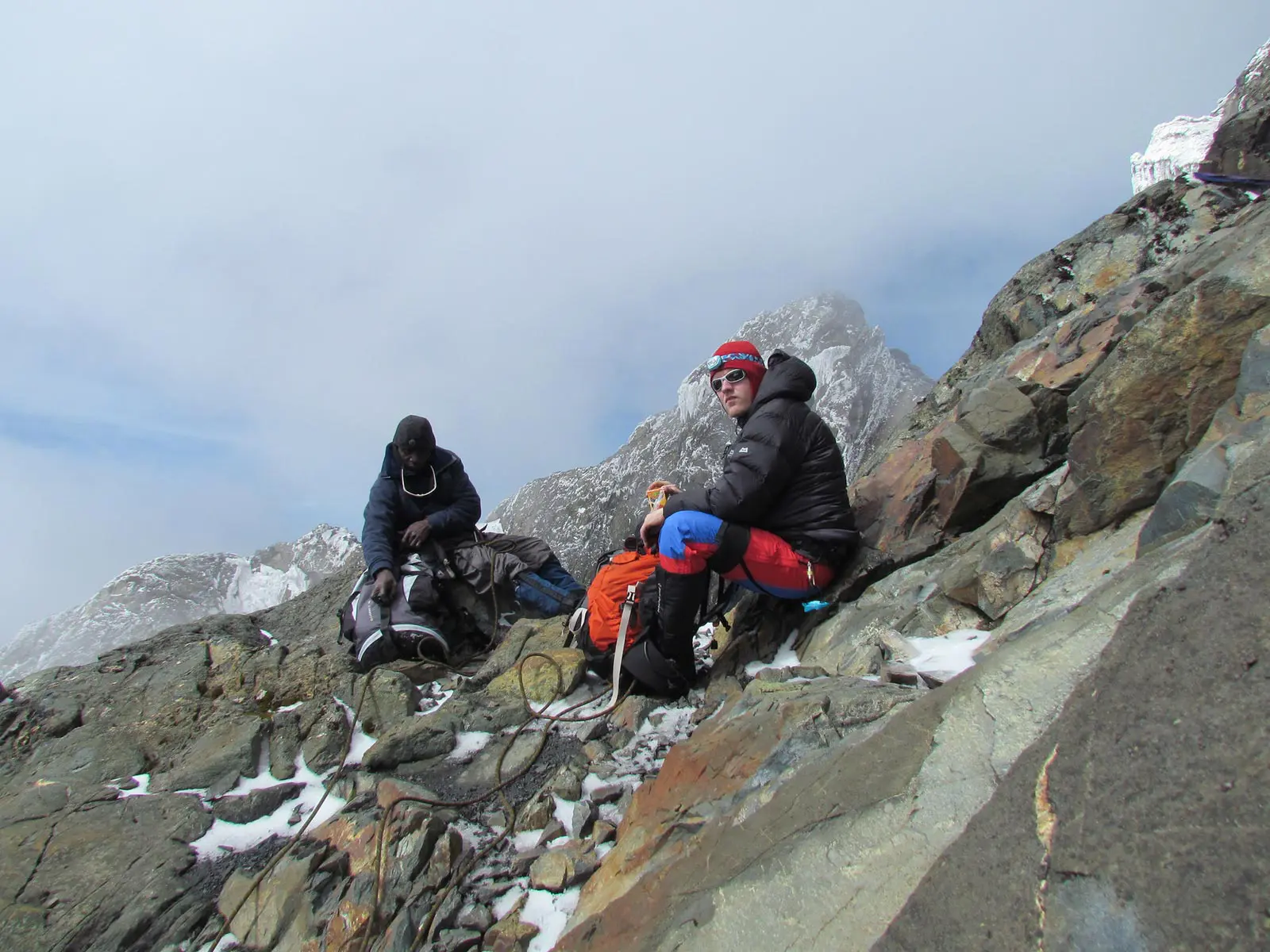
At four o’clock in the morning, the alarm goes off. For your second peak, you’ll need technical equipment for the first time. A brief glacier portion near the summit ridge leads climbers to Edward Peak, at 4,844 m, atop Mount Baker, after a sustained difficult ascent. At the edge of the glacier, you’ll find the anchors; your guide will attach the rope, and the whole summit party will work together. Bear in mind that the technical environment is real, even though the Baker glacier and ropework are smaller than Stanley’s.
One of the most memorable parts of the journey was the nighttime ascent by torch. Mount Stanley’s twin glaciated summits become visible toward the northwest as sunrise lights up the eastern sky. The enormity of your task is now crystal clear to you. The Freshfield Pass corridor, the high ridgeline connecting the Stanley massif to the residual Baker glacier, and the Freshfield Pass corridor are all visible from Edward Peak, which stands at 4,844 m. Before tomorrow’s transition day, the descent heads down to Butawu Camp for a long rest, recuperation, and resupply.
Summit departure: 4:00–4:30 am. Return to camp: midday to early afternoon. Hot dinner at Butawu Camp.
Day 8: Butawu Camp (3,974 m) → Lake Kitandara → Margherita Camp (4,485 m)
Distance: ~5.5 km | Elevation Gain: +511 m | Hiking Time: 4–6 hours
On day 8, you will make your way to the base of Mount Stanley and give your body one last night of moderate-altitude rest before climbing the glacier. This is a transitional day with two goals. From Butawu, the trail drops down to Lake Kitandara, one of East Africa’s most picturesque high-alpine lakes, which is at an elevation of about 4,023 meters. On calm mornings, the reflection is so clear that it takes a second to tell which direction is up as the dark water flawlessly reflects the rock faces above.
The trail begins its ascent from Lake Kitandara via Scott Elliott’s Pass, which is named for the explorer who first charted these regions in 1895. The pass is roughly 4,372 meters high. Beyond the pass, the landscape gets more rocky and exposed, and you can see the Margherita glacier up above. This marks the change to the Stanley approach zone. Perched on a narrow shelf below the glacier’s terminal moraine, Margherita Camp is a collection of sturdy huts that stands at 4,485 meters, making it the highest permanent camp along the Kilembe Trail. Get as much sleep as you can tonight, eat everything on your plate, and drink more than you think you need. Time: 4:00 in the morning.
Meals: Hot breakfast at Butawu. Packed lunch on trail. Early, substantial hot dinner at Margherita Camp.
Day 9: SUMMIT 3: Margherita Peak (5,109 m) → Rest at Margherita Camp
Round Trip from camp: ~5 km | Elevation Gain: +624 m | Summit Time: 7–10 hours
🥇 PEAK 3 OF 8: Margherita Peak, 5,109 m Africa’s Third Highest Summit
third-highest peak in Africa. The Rwenzori Mountain Roof. All of the other ascents have been practice for this one, the most technically challenging peak of the expedition. The moment you hear the alarm go off at 4:00 (or even 3:30) in the morning, everything becomes crystal clear: today is the day.
In complete darkness, with temperatures ranging from -5°C to -15°C (seasonally and wind-dependent), you set out. Section one uses flashlights to ascend rough terrain above camp; when they do so, they illuminate the distant Stanley Glacier, which is only visible in its faintest form. The rope crew gets together, and the crampons are fastened. There are crevasses, the surface is really ice, and fixed ropes guard the steepest sections of the glacier approach to Margherita Peak, making it the most difficult technical terrain of the entire journey. The expertise of your guide in this area is quite essential.
Arriving at 5,109 meters above sea level, the summit is a testament to the full force of acquired altitude. Standing atop ice, which has endured for millennia under the equatorial sun, is now retreating permanently. On a sunny morning at the peak, you can make out the Virunga volcanic range in the DRC to the south and the vast Western Rift Valley in Uganda to the east. Get some rest for the rest of the day; the descent to Margherita Camp takes about two or three hours. Tomorrow, Alexandra Peak will be in view.
Summit departure: 3:30–4:00 am. Return to Margherita Camp by early afternoon. Rest thoroughly.
Day 10: SUMMIT 4: Alexandra Peak (5,083m) → Return to Margherita Camp
Round Trip from camp: ~4 km | Elevation Gain: +598 m | Summit Time: 6–9 hours
🥈 PEAK 4 OF 8: Alexandra Peak, 5,083 m (Mount Stanley)
On the 18-day 8-Peaks Rwenzori Trek, the most technically challenging phase is the snowy ridge traverse that separates Margherita and Alexandra Peak, the second-highest summit of Mount Stanley (5,083 m). Despite the seeming proximity of the two peaks—just 500 meters in horizontal distance—a glaciated arête separates them, necessitating strict adherence to technical rope discipline, precise crampon positioning, and unwavering faith in your guide.
Alexandra is 26 meters lower than Margherita, but many hikers find it psychologically harder. The icy ridge traverse is more exposed than any part of the Margherita route, and reaching the summit the day following Margherita’s exertions adds to the cumulative exhaustion. Climbers who make it to the top of both mountains always say that Alexandra was the more remarkable of the two. Nothing beats the sensation of truly alpine terrain at an altitude of over 5,000 meters on the equator. From Alexandra, you can see the approach routes you just finished and the Elena Glacier below you on the summit.
Make your way back to Margherita Camp and give yourself as much rest as you can. On top of Africa, there are eight summits, and you have reached the fourth summit. The journey upto Mount Speke will commence tomorrow.
Summit departure: 5:00–6:00 am. All summit days require full technical gear. Return by early afternoon.
Day 11: Margherita Camp (4,485 m) → Elena Camp / Speke Base (~4,300–4,500 m)
Distance: ~7–9 km | Complex, traversing terrain | Hiking Time: 6–8 hours
The central traverse, the expedition’s most inaccessible and technically challenging mobility segment, starts on day 11. Ascending from Margherita Camp, you will start to follow the rocky contours that encircle the Stanley massif. You will cross high scree slopes and glacial moraines, which connect the Stanley and Speke massifs. Except for the most dedicated members of the Rwenzori expedition, this trip takes place across very unfamiliar landscape.
Your starting location for climbing Mount Speke will be Elena Camp, which is located halfway between Stanley and Speke. Due to the camp’s location on a rocky outcrop, you should bring a high-quality sleeping bag and windproof clothing to keep warm after dark. Before confirming the plan for the Speke summit this evening, your guide will evaluate the circumstances, weather, and group fitness.
Meals: Hot breakfast at Margherita Camp. Packed lunch on traverse. Hot dinner at Elena/Speke base camp.
Day 12: SUMMIT 5: Mount Speke; Vittorio Emanuele Peak (4,890 m) → Return to Camp
Round Trip from camp: ~7 km | Elevation Gain: ~400–500 m | Summit Time: 6–8 hours
⛰️ PEAK 5 OF 8: Vittorio Emanuele Peak, 4,890 m (Mount Speke)
The second-highest massif in the Rwenzori, Mount Speke (4,890 m), has a completely different character than the Stanley mountains, and its peak, Vittorio Emanuele, gives a unique view. Less glacier travel and more persistent rocky scrambling on the top ridges characterise the ascent, with parts requiring steady hands and calm decision-making on exposed terrain. The typical whirling mist of the Rwenzori often envelops Speke’s summit, which, far from being a letdown, makes for one of the most atmospherically remarkable summit experiences in mountaineering in Africa.
Mount Stanley to your rear, the northern peaks of Emin and Gessi to your front, and the breathtaking glacial cirques below are all visible on a clear morning from Vittorio Emanuele Peak, which forms the whole arc of the Rwenzori spine. At this precise time, the expedition has reached its geographic peak, the point from which all of the other peaks are visible at once. The descent gets you back to camp just in time for some much-needed rest and fuel. More northern summits are on the way.
Summit departure: 5:00 am. Return to camp by mid-afternoon. Rest and nutrition priority.
Day 13: Traverse: Speke Base → Northern Peaks Base Camp (~3,800–4,200 m)
Distance: ~10–12 km | Complex terrain | Hiking Time: 7–9 hours
From the Speke-Stanley zone, the expedition descends into the area of the Rwenzori’s most remote massifs, Emin and Gessi, on Day 13, the big connector of the expedition, a lengthy and arduous journey across the northern half of the Rwenzori high country. The environment is very unique, with ancient Dendrosenecio groundsel trees dominating the valleys. Some of these trees are over a century old and have enormous, umbrella-shaped crowns.
On Day 13, you can feel the remoteness in the northern zone of the Rwenzori because there are considerably less visitors compared to the Stanley-Baker route. The area your porter team traverses demands extensive route expertise; the camp where you will be spending the night is situated to provide consecutive days of access to both Mount Emin and Mount Gessi. Because you are about to enter the last summit cluster of the adventure, dinner is of utmost importance.
Meals: Hot breakfast. Packed lunch. Hot dinner at northern base camp.
Day 14: SUMMIT 6: Mount Gessi; Bottego Peak (4,715 m) → Return to Camp
Round Trip: ~8 km | Elevation Gain: ~500–600 m | Summit Time: 6–9 hours
⛰️ PEAK 6 OF 8: Bottego Peak, 4,715 m (Mount Gessi)
Out of all the Rwenzori massifs, Mount Gessi (4,715 m) stands out as one of the most stunning and seldom-climbed. Bottego Peak, the highest point of the adventure, is reached over exposed scrambling terrain and steep rocky ledges, which provide the most vertical drop-offs of any summit. Glacial erosion has shaped the ancient Precambrian gneiss and granite that makes up Gessi’s architecture into precipitous arêtes and sheer, cliff-face faces that demand steady nerves and meticulous route-finding.
From 4,715 meters up on Bottego Peak, you can see the whole northern Rwenzori range: the Emin massif to the left, Stanley’s melting glaciers in the distance to the south, and a massive chasm stretching eastward to the floor of the Rift Valley. At any given year, very few mountaineers get to reach the peak. Go back to camp around midday so you may relax and be ready to climb Mount Emin tomorrow.
Summit departure: 5:00–5:30 am. Return by early afternoon. Full rest before Emin.
Day 15: SUMMIT 7: Mount Emin: Umberto Peak (4,798 m) → Return to Camp
Round Trip: ~9 km | Elevation Gain: ~600–700 m | Summit Time: 7–10 hours
⛰️ PEAK 7 OF 8: Umberto Peak, 4,798 m (Mount Emin)
The legendary Emin Pasha Eduard Schnitzer, the German-born Ottoman ruler of Equatoria, is honoured by the name of Mount Emin (4,798m). His rescue served as one of the declared reasons for Henry Morton Stanley’s renowned 1887–1889 expedition, which introduced the Rwenzori to Europeans. Emin’s summit, Umberto Peak, is approached over exposed ridgeline terrain with sharp edges and areas of real scrambling on loose rock that require focus.
By Day 15, your body embodies seventeen days of cumulative exertion. The legs possess strength yet remain cognisant of their burden; the lungs are acclimatised to elevation but perceive each incremental metre. This is precisely where expedition experience becomes crucial: the discipline to progress slowly and gradually, maintain continuous nourishment and hydration, and trust that the summit will be attained. Umberto Peak, at 4,798 meters, represents the penultimate summit of the expedition, and the descent to camp is particularly gratifying, as only one peak remains.
Summit departure: 5:00am. Return to camp by early afternoon. Celebrate carefully; you have one more day.
Day 16: Northern Base → Traverse South → Bugata Camp (4,062 m)
Distance: ~12–15 km | Long descent and re-ascent | Hiking Time: 8–10 hours
On day 16, the expedition’s northern loop comes to a finish and the southward adventure through the Rwenzori’s interior begins. Leaving the Emin-Gessi zone on Day 5, you began the summit sequence at Bugata Camp, which you reascend to reach 4,062 m after descending through the moorland basins. Upon your return to Bugata, you will find that the camp has taken on a new vibe—one that is both familiar and earned, and charged with the knowledge of the challenges posed by the surrounding peaks.
During the transitions between vegetation zones, the route passes over some of the most botanically rich terrain of the entire expedition. At this point in the journey, you are familiar with every facet of the Rwenzori: the aroma of the Afro-alpine bog, the sound of the wind in the heather forests, and the unique quality of the light that occurs shortly after sunrise as the mist burns off the ridges. The night at Bugata Camp will serve as a rest stop before tomorrow’s last ascent to Summit 8.
Meals: Hot breakfast. Packed lunch on traverse. Hot dinner at Bugata Camp.
SUMMIT 8: Cheptegei Peak (4,907 m); Optional via Bugata Approach
Summit excursion from Bugata area | Elevation: 4,907 m | Time: 6–8 hrs if attempted
⛰️ PEAK 8 OF 8: Cheptegei Peak, 4,907 m (Mount Stanley massif)
Located in the Stanley massif, above the Bugata approach zone, the eighth and last summit of the trip is Cheptegei Peak (4,907 m). An impressive peak that is never included in even the most extensive Rwenzori itineraries, its elevation puts it above Speke, Emin, Gessi, and Luigi di Savoia. A direct climb on rocky terrain above the alpine zone is required for access from the Bugata Camp area, with some scrambling sections on the high ridge.
Group fitness, weather, and your guide’s discretion following 15 days of continuous high-altitude work will determine if Cheptegei attempts it. If the weather is right and the team is up to the challenge, our seasoned expedition leaders will give you the straight scoop. The safety call is made if it is not advisable due to conditions or cumulative weariness. This is the type of expert decision-making that ensures the safety of Rwenzori trips and in no way compromises their integrity. Before descending, you must return to Bugata Camp.
Summit attempt dependent on conditions and group assessment. Full rest day at Bugata if not attempted.
Day 17: Bugata Camp (4,062 m) → Sine Camp (2,596 m)
Distance: ~13 km | Elevation Loss: -1,466 m | Hiking Time: 5–7 hours
The descent starts. The bulk of the expedition, which had been at an altitude of more than 3,500 meters for several days, descended through the altitudinal zones in the opposite direction, providing an intense sensory experience. Every hundred meters down, you can see the jungle getting thicker. More heat is being generated. Saturation levels rise. The lush avian soundtrack of the forest, which had been missing for more than a week, is once again created by the melodic calls of turacos, sunbirds, and flycatchers. Heather and bamboo eventually replace the massive lobelias and groundsel trees that once graced the moorland.
After the high camps, Sine Camp (2,596 m), which is reached in the middle of the afternoon, has an almost tropical feel. As you cross the vertical globe, the nighttime sounds of the forest—insects, faraway water, and the occasional monkey call—serve as a constant reminder of its massive size. The modest grace of an accomplished journey is in the air as we dine this evening.
Meals: Hot breakfast at Bugata. Packed lunch on trail. Hot dinner at Sine Camp
Day 18: Sine Camp (2,596 m) → Kilembe Base Camp (1,450 m) → Kasese
Distance: 9.5 km | Elevation Loss: -1,146 m | Hiking Time: 4–5 hours
That was the last morning up there. Returning home via the Nyamwamba Valley takes you through a lower forest teeming with Afro-montane bird species, duikers, and colobus monkeys. After seventeen days of thin, cold, mineral-scented mountain air, the air is thick, warm, and perfumed. Returning to the lowland environment is an adjustment that occurs with each step of the descend.
The Kilembe Trekkers Hostel is seen after the last stretch of jungle. Take off your boots. Every piece of gear is traceable to the equipment team. After 18 days of exceptional labour, these mountain experts have won the respect and kindness of the porters who dispense tips. Twenty minutes later, you’ll be back in Kasese thanks to a transfer vehicle. Reaching the summit of each of the eight main Rwenzori peaks in a single, uninterrupted ascent is one of the most prestigious climbing feats in Africa, and you have accomplished it.
Meals: Hot breakfast at Sine Camp. Packed lunch on trail. Celebration dinner in Kasese (own arrangement).
End of the 18-Day 8-Peaks Rwenzori Trek Expedition